blog authors
past blog entries

Welcome to the Kellylab blog

geospatial matters

Please read the UC Berkeley Computer Use Policy. Only members can post comments on this blog.

Tuesday
Mar222016

Bootcamp is here! Spatial Data Science 2016

Spatial Data Science for Professionals

We live in a world where the importance of spatial data is ever increasing. Many of the societal challenges we face today — fire response, energy distribution, efficient resource allocation, land use, food scarcity, invasive species, climate change, privacy and safety — are associated with big spatial data.  Addressing these challenges will require trained analysts fluent in:
  • integrating disparate data, from aircraft, satellites, mobile phones, historic collections, public records, the internet;
  • using easily available and open technology for robust data analysis, sharing, and publication;
  • understanding and applying core spatial analysis methods;
  • and applying visualization tools to communicate with project managers, policy-makers, scientists and the public.

Mastering these challenges requires Spatial Data Science: big data tools, geospatial analytics, and visualization. Today’s marketplace needs trained analysts who know how to find, evaluate, manage, analyze and publish spatial data in a variety of environments. With this hands-on Spatial Data Science Bootcamp for professionals, you can expand your GIS skill level and learn how to integrate open source and web-based solutions into your GIS toolkit by gaining an understanding of spatial data science techniques.

The goal of this Spatial Data Science Bootcamp is to familiarize participants with the modern spatial data workflow and explore open source and cloud/web based options for spatial data management, analysis, visualization and publication. We’ll use hands-on exercises that leverage open source and cloud/web based technologies for a variety of spatial data applications.

https://iep.berkeley.edu/spatial/iep-spatial-bootcamp-overview

Tuesday
Mar082016

LandFire is looking for field data! Add yours now. 

I wanted to send out a friendly reminder that the data submission deadline for the current data call is March 31, 2016.  Data submitted before March 31 are evaluated for inclusion in the appropriate update cycle, and submissions after March 31 are typically considered in subsequent updates.  

This is the last call for vegetation/fuel plot data that can be used for the upcoming LANDFIRE Remap. If you have any plot data you would like to contribute please submit the data by March 31 in order to guarantee the data will be evaluated for inclusion in the LF2015 Remap. LANDFIRE is also accepting contributions of polygon data from 2015/2016 for disturbance and treatment activities. Please see the attached data call letter for more information.

Brenda Lundberg, Senior Scientist

Stinger Ghaffarian Technologies (SGT, Inc.)

Contractor to the U.S. Geological Survey (USGS)

Earth Resources Observation & Science (EROS) Center

Phone: 406.329.3405

Email: blundberg@usgs.gov

Tuesday
Mar082016

IGIS exploring applications of drones for UC Agriculture and Natural Resources

IGIS is excited to be working with 3D Robotics (3DR) to explore new applications of small unmanned aerial systems (sUAS) for monitoring agriculture and natural resources.  This technology has never been more practical for scientific exploration; however, there is still much to be learned about how to best utilize sUAS in this way.

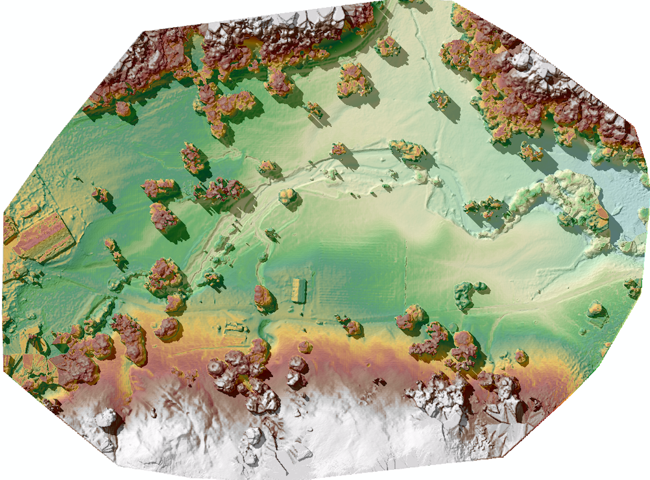
DEM from drone flightIGIS is now developing protocols for safe and efficient deployment of a 3DR Solo sUAS.  Equipped with a common 12 megapixel GoPro Hero camera, this platform can survey up to 75 acres, at 3 inches of spatial resolution in less than 20 minutes, while flying a pre-defined flight path at 23 miles per hour, at 300 feet above ground level.  Then thanks to Pix4D mapping software, which is used to combine the pictures collected by the sUAS's GoPro into a single image mosaic, automated photogrammetric processes can render a digital terrain model from the images with a vertical accuracy close to the same 3 inches spatial resolution found in the original image collection.

IGIS has introduced sUAS and remote sensing training into our workshop schedule for this year.  Please check out our IGIS training calendar by Clicking Here for more information.

Monday
Mar072016

New IGIS Academic Coordinator: Andy Lyons

I would like to welcome Andy Lyons as Academic Coordinator III in the ANR Informatics and GIS (IGIS) Statewide Program. Andy comes to ANR from Stanford and before that Berkeley, where he completed his PhD in ESPM. He has an exceptionally broad academic training, bridging both the social and natural sciences, with considerable experience within both academic and not-for-profit business environments. He has a strong combination of ecology, social science, data science, and computer applications (programming, data management, multimedia, web, modeling), and grant/report writing skills. He is also a gifted teacher, won awards for his teaching at Cal including an Outstanding Graduate Instructor Award in 2004, and has been one of our instructors at the GIF's Spatial Data Science Bootcamp.

Thursday
Feb252016

Data Science for the 21st Century - External Partners Invited!

Developing data-driven solutions in the face of rapid global change

Global environmental change poses critical environmental and societal needs, and the next generation of students are part of the future solutions.  This National Science Foundation Research Traineeship (NRT) in Data Science for the 21st Century prepares graduate students at the University of California Berkeley with the skills and knowledge needed to evaluate how rapid environmental change impacts human and natural systems and to develop and evaluate data-driven solutions in public policy, resource management, and environmental design that will mitigate negative effects on human well-being and the natural world.  Trainees will research topics such as management of water resources, regional land use, and responses of agricultural systems to economic and climate change, and develop skills in data visualization, informatics, software development, and science communication.

In a final semester innovative team-based problem-solving course, trainees will collaborate with an external partner organization to tackle a challenge in global environmental change that includes a significant problem in data analysis and interpretation of impacts and solutions. This collaboration is a fundamental and distinguishing component of the NRT program. We hope this collaboration will not only advance progress on the grand challenges of national and global importance, but also be memorable and useful for the trainees, and for the partners.

An Invitation to Collaborate

We are inviting collaboration with external partners to work with our students on their Team Research Project in 2016-17. Our students would greatly benefit from working with research agencies, non-profits, and industry.

  • Our first cohort of 14 students come from seven different schools across campus, each bringing new skillsets, backgrounds, and perspectives.
  • Team projects will be designed and executed in the spring of 2017.
  • Partners are welcome to visit campus, engage with students and take part in our project activities.
    • Join us at our first annual symposium on May 6th 4-7 pm.
    • Participate in workplace/ campus exchange.
    • Contact the program coordinator at hconstable@berkeley.edu
    • Visit us at http://ds421.berkeley.edu/ for more information.

This new NSF funded DS421 program is in the first of 5 years. We look forward to building ongoing collaborations with partners and UC Berkeley.

Tuesday
Jan262016

With Drought Comes Disease

You’ve heard that millions of California’s trees have died from drought and bark beetles. Weakened by lack of water due to four consecutive years of drought, over 29 million conifers and hardwood trees were unable to fight off attacks from bark beetles and died. Check out where and when these trees have died across California using the new Tree Mortality Viewer from FRAP, CalFire, and USFS

Tree Mortality Viewer: Mortality at Point Reyes National Seashore

Overlayed on a map of California, the Viewer visibility layers show:

  • Tree Mortality — Results of 2012-2015 aerial tree-mortality surveys. See how the situation has dramatically worsened over the years

You can download the original data  here too!

Monday
Jan252016

Spring 2016 GIF Workshops 

Spring 2016 GIF Workshops 

The Geospatial Innovation Facility is excited to announce that we will be offering our standard workshops series for FREE this spring to UC Berkeley students, faculty, and staff. Currently we still need to retain our pricing of $224 for all non-UC affiliates. However, space is limited and the workshops will be filled on a first-come first-served basis, so register today at to take advantage of these great training opportunities!

GIF workshops offer hands-on applications oriented training in a variety of geospatial topics. Our Introduction to Geographic Information Systems (GIS) and Introduction to Remote Sensing workshops are designed for participants with little to no experience in GIS, or those who would like to refresh their geospatial skills. Each workshop teaches core geospatial principals and techniques through a combination of lecture and hands-on interactive activities.  

We are currently accepting registration for our introductory series of workshops offered over the next several weeks. See more detailed descriptions and register for any of the upcoming trainings at: http://gif.berkeley.edu/support/workshops.html

January 29: Intro to GIS: Social Science Focus

The presentation will get you up to speed on what kind of analyses GIS may be used for, as well as the basic structures of spatial data. After the lecture you will follow an interactive exercise that has been designed to introduce you to ArcGIS Desktop software while analyzing street and census data around the City of Berkeley.

February 5: Intro to GIS: Environmental Science Focus

The presentation will get you up to speed on what kind of analyses GIS may be used for, as well as the basic structures of spatial data. After the lecture you will follow an interactive exercise that has been designed to introduce you to ArcGIS Desktop software while analyzing environmental data from around Lake Tahoe.

February 12: Intro to Open Source GIS: Using QGIS

QGIS is a free and open source geospatial desktop application that has been developing at a rapid pace. Its ease of use and accessibility (available for PC, Mac, and Linux platforms) has created a strong and active user community. In this workshop, we will explore the basic functionality of QGIS so that you may quickly learn how to load and format vector and raster data, edit shapefiles, and query attributes. 

February 19: Intro to GIS for Agriculture: Rangeland Focus

An introductory presentation will get you up to speed on what kind of analyses GIS may be used for, as well as the basic structures of spatial data. After this brief lecture you will follow an interactive exercise that will introduce you to using free and open source online data to analyze and map rangelands in the California Central Valley.

February 26: Intro to Remote Sensing: Understanding Digital Imagery

This workshop introduces basic principles of understanding digital imagery, both satellite and aerial. Through a combination of lecture and interactive activities, we will explore what makes up a multi-spectral image, where to find and download them, and how to view and manipulate imagery.

These workshops are held in 124 Mulford Hall and run from 1pm – 4:30pm. Sign-up now for this great opportunity for intensive, hands-on training in geospatial methods, tools, and analysis!

Tuesday
Jan192016

GIF & IGIS from space

Made this for fun for the GIF & IGIS from NASA's "abcs from space" site: http://earthobservatory.nasa.gov/Features/ABC/. Was going to do "Kellylab" but ran out of time.

  • G: This image of Pinaki Island was captured by astronauts on the International Space Station in April 2001.
  • I: On February 10, 2007, the Moderate Resolution Imaging Spectroradiometer (MODIS) on NASA’s Terra satellite captured this image of the Andaman Islands. The thin, bright rings surrounding several of the islands are coral reefs that were lifted up by a massive earthquake near Sumatra in 2004.
  • F: The Operational Land Imager (OLI) on Landsat 8 acquired this false-color image of valleys and snow-covered mountain ranges in southeastern Tibet on August 4, 2014. Firn is a granular type of snow often found on the surface of a glacier before it has been compressed into ice.

  • I: On February 10, 2007, the Moderate Resolution Imaging Spectroradiometer (MODIS) on NASA’s Terra satellite captured this image of the Andaman Islands. The thin, bright rings surrounding several of the islands are coral reefs that were lifted up by a massive earthquake near Sumatra in 2004.
  • G: This image of Pinaki Island was captured by astronauts on the International Space Station in April 2001.
  • S: On April 29, 2009, the Moderate Resolution Imaging Spectroradiometer (MODIS) on the Terra satellite acquired this image of clouds swirling over the Atlantic Ocean.
Friday
Jan152016

ESRI @ GIF Open GeoDev Hacker Lab

We had a great day today exploring ESRI open tools in the GIF. ESRI is interested in incorporating more open tools into the GIS workflow. According to www.esri.com/software/open, this means working with:

  1. Open Standards: OGC, etc. 
  2. Open Data formats: supporting open data standards, geojson, etc. 
  3. Open Systems: open APIs, etc. 

We had a full class of 30 participants, and two great ESRI instructors (leaders? evangelists?) John Garvois and Allan Laframboise, and we worked through a range of great online mapping (data, design, analysis, and 3D) examples in the morning, and focused on using ESRI Leaflet API in the afternoon. Here are some of the key resources out there.

Great Stuff! Thanks Allan and John

Tuesday
Jan122016

Spatial Data Science Bootcamp March 2016

Register now for the March 2016 Spatial Data Science Bootcamp at UC Berkeley!

We live in a world where the importance and availability of spatial data are ever increasing. Today’s marketplace needs trained spatial data analysts who can:

  • compile disparate data from multiple sources;
  • use easily available and open technology for robust data analysis, sharing, and publication;
  • apply core spatial analysis methods;
  • and utilize visualization tools to communicate with project managers, the public, and other stakeholders.

To help meet this demand, International and Executive Programs (IEP) and the Geospatial Innovation Facility (GIF) are hosting a 3-day intensive Bootcamp on Spatial Data Science on March 23-25, 2016 at UC Berkeley.

With this Spatial Data Science Bootcamp for professionals, you will learn how to integrate modern Spatial Data Science techniques into your workflow through hands-on exercises that leverage today's latest open source and cloud/web-based technologies. We look forward to seeing you here!

To apply and for more information, please visit the Spatial Data Science Bootcamp website.

Limited space available. Application due on February 19th, 2016.