 Public interest in Sudden Oak Death remains high as the disease continues to spread in California. Early in the infestation, information from the public was key in locating new areas of infestation across the state. The California Oak Mortality Task Force, arborists, and university researchers were repeatedly contacted with reports of new areas of suspected infestations. In response to this concern from the public, we created a web site where visitors could submit the locations of trees that were potentially infected, as well as find recent and officially confimed samples of P. ramorum. This site, OakMapper (www.oakmapper.org), has had thousands of visitors, who have submitted hundreds of locations. We continue to develop and refine the OakMapper website, using up to date webGIS technologies. The site is now based on Open Source technologies.
OakMapper iOS Upgrade!
A new version (v2.2) of the OakMapper iPhone App has been released on the iTunes App Store. The latest release takes advantage of the improved iOS mapping capability to display community-submitted polygons. It also comes with a number of functionality improvements (i.e. user login and profile management, improved browsing and searching capabilities, submission of SOD pictures, and etc.) as well as user interface/interaction redesign (i.e. new SOD submission workflow, the change of SOD case detail page layout, a simple tutorial about OakMapper, and many others). This release now works on iPad as well. If you have not used the OakMapper App on your iOS devices, try it out. If you have already downloaded the previous version, make sure you upgrade now and experience all the improvements in this new release.
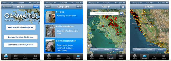
Check out more information on the upgrade here.
Older news: The new OakMapper 2.0 is up and running, and we'd like your help in mapping areas of oak mortality around the state. OakMapper 2.0 makes it easier for users to explore data, download maps, look at images of oak mortality, and submit suspected locations of oak mortality that may be associated with SOD. The new interface utilizes the familiar background layers and navigation tools from Google Maps. Users are able to draw points and polygons directly on the map as well as attach photos to specific points. Please consider signing up to be an OakMapper user!
Publications that relate to the OakMapper project are here, and blog posts that relate to the project are here.