publications by year

Selected Publications

My CV can be found here, my Google Scholar page is here and my Research Gate page is here. Links to directly downloadable papers are provided when possible - these are for individual use only; links to journals are also provided, but might not be available to users without campus library access. All papers are available upon request.

Entries in desheng liu (8)

Wednesday
Dec312008

Spatial pattern dynamics of oak mortality & disease symptoms

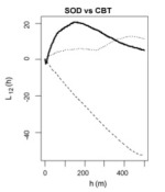
Kelly et al. 2008. Journal of Forest Research. We used two-dimensional spatial analysis tools with data gathered in point-centered-quarter format in 2001 and 2004 to quantify 1) population density of the disease through time; 2) spatial pattern of tree mortality across scales through time; and 3) spatial co-occurrence of disease symptoms with crown mortality through time.
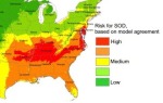
Click to read more ...

Wednesday
Oct312007

Spatial‐temporal tree mortality patterns associated with SOD

Liu, et al. 2007. Forest Ecology and Management. Inhomogeneous cross-K-functions of SOD and California bay trees: the peak in the dark line indicates co-clusteringWe analyzed the spatial–temporal patterns of overstory oak tree mortality in China Camp State Park, CA over 4 years using the point patterns mapped from high spatial resolution remotely sensed imagery. Both univariate and multivariate spatial point pattern analyses were performed (inhomogeneous K-functions and Neyman–Scott point processes) to characterize the spatial dependence among dead oak trees in each year, and between dead oaks and CA bay trees.

Click to read more ...

Sunday
Sep302007

Modeling SOD risk in the United States

Kelly, et al. 2007. Computers, Environment and Urban Systems. Risk for SOD in the southeast based on model agreementUsing the locations of P. ramorum in CA we derived a risk map for SOD spread in the conterminous US using 5 environmental niche models: Expert-driven Rule-based, Logistic Regression, Classification and Regression Trees, Genetic Algorithms, and Support Vector Machines.

Click to read more ...

Monday
Apr302007

Obia for mapping dead trees

Guo, Q. C., M. Kelly, P. Gong and D. Liu. 2007. GIScience and Remote Sensing. An object, defined by spectral similarity of neighboring pixelsWe developed an object-based approach, including an image segmentation process and a knowledge-based classifier, to detect individual tree mortality in imagery of 1 m spatial resolution.

Click to read more ...

Sunday
Dec312006

Automatic registration of airborne images

Liu, et al. 2006. Photogrammetric Engineering and Remote Sensing. Deformation vector plots overlaid on areas with high and low texture.Accurate registration of airborne images is challenging because complex local geometric distortions are often involved in image acquisition. We propose a solution to this registration problem in two parts: 1) an area-based method to extract sufficient numbers of well-located control points, 2) we use the extracted control points with local transformation models to register multi-temporal airborne images.

Click to read more ...

Wednesday
May312006

Spatial‐temporal monitoring of forest disease dynamics

Liu et al. 2006. Remote Sensing of Environment. Traditional mapping approaches using per-pixel, single-date image classifications have not generated consistently satisfactory results. Incorporation of spatial–temporal contextual information can improve these results. In this paper, we propose a spatial–temporally explicit algorithm to classify individual images using the spectral and spatial–temporal information derived from multiple co-registered images.

Click to read more ...

Tuesday
May312005

Mapping oak mortality using high res CIR imagery

Kelly, et al. 2004. Photogrammetric Engineering and Remote Sensing. Supervised, unsupervised, and “hybrid” classification methods were evaluated for their accuracy in discriminating dead and dying tree crowns from bare areas and the surrounding forest mosaic utilizing 1-m ADAR imagery covering both tanoak/redwood forest and mixed hardwood stands. In both study areas the hybrid classifier significantly outperformed the other methods.

Click to read more ...

Monday
Jul262004

Mapping diseased oak trees using ADAR imagery

Kelly and Liu. 2004. Geocarto International. We investigated the ability of high spatial-resolution 4-band imagery (Airborne Digital Acquisition and Registration - ADAR) to discern moisture stress in trees affected by Sudden Oak Death (SOD). The results suggest an inability to automate mapping of moisture stress in oaks using ADAR imagery, and limited success in using methods that require extensive field data.

Click to read more ...