publications by year

Selected Publications

My CV can be found here, my Google Scholar page is here and my Research Gate page is here. Links to directly downloadable papers are provided when possible - these are for individual use only; links to journals are also provided, but might not be available to users without campus library access. All papers are available upon request.

Entries in brandon collins (7)

Tuesday
Jun282016

New paper: Mapping forest fuel treatments using Lidar

Su, Y, Q Guo, B M Collins, D L Fry, T Hu, and M Kelly. 2016.  Forest fuel treatment detection using multi-temporal airborne lidar data and high-resolution aerial imagery: a case study in the Sierra Nevada Mountains, California. International Journal of Remote Sensing 37(14): DOI: 10.1080/01431161.2016.1196842

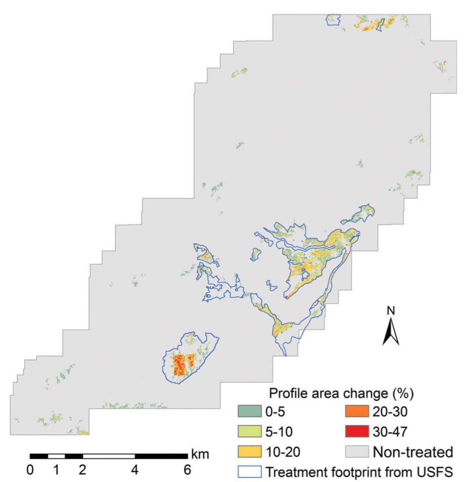
Forest change detection using lidarTreatments to reduce forest fuels are often performed in forests to enhance forest health, regulate stand density, and reduce the risk of wildfires. Although commonly employed, there are concerns that these forest fuel treatments (FTs) may have negative impacts on certain wildlife species. Often FTs are planned across large landscapes, but the actual treatment extents can differ from the planned extents due to operational constraints and protection of resources (e.g. perennial streams, cultural resources, wildlife habitats). Identifying the actual extent of the treated areas is of primary importance to understand the environmental influence of FTs. Light detection and ranging (lidar) is a powerful remote-sensing tool that can provide accurate measurements of forest structures and has great potential for monitoring forest changes. This study used the canopy height model (CHM) and canopy cover (CC) products derived from multi-temporal airborne laser scanning (ALS) data to monitor forest changes following the implementation of landscape-scale FT projects.

Click to read more ...

Thursday
Feb042016

New paper: mapping vegetation with lidar and aerial imagery

Su, Y, Q Guo, D L Fry, B M Collins, M Kelly, J P Flanagan & J J Battles. 2016. A Vegetation Mapping Strategy for Conifer Forests by Combining Airborne Lidar Data and Aerial Imagery. Canadian Journal of Remote Sensing 42:1–15 DOI: 10.1080/07038992.2016.1131114 

Accurate vegetation mapping is critical for natural resources management, ecological analysis, and hydrological modeling, among other tasks. Remotely sensed multispectral and hyperspectral imagery have proved to be valuable inputs to the vegetation mapping process, but they can provide limited vegetation structure characteristics, which are critical for differentiating vegetation communities in compositionally homogeneous forests. Light detection and ranging (lidar) can accurately measure the forest vertical and horizontal structures, and provide a great opportunity for solving this problem. This study introduces a strategy using both multispectral aerial imagery and lidar data to map vegetation composition and structure over large spatial scales.

Click to read more ...

Monday
Dec142015

Impacts of forest fuel treatments and wildfire on forests

Tempel, DJ, RJ Gutiérrez, JJ Battles, DL Fry, Y Su, Q Guo, MJ Reetz, SA Whitmore, GM Jones, BM Collins, SL Stephens, M Kelly, WJ Berigan, and MZ Peery. 2015. Modeling short- and long-term impacts of fuel treatments and wildfire on an old-forest species. Ecosphere 6(12) DOI:10.1890/ES15-00234.1

Fuels-reduction treatments are commonly implemented in the western U.S. to reduce the risk of high-severity fire, but they may have negative short-term impacts on species associated with older forests.   Therefore, we modeled the effects of a completed fuels-reduction project on fire behavior and California spotted owl (Strix occidentalis occidentalis) habitat and demography in the Sierra Nevada to assess the potential short- and long-term trade-offs.  We combined field-collected vegetation data and LiDAR data to develop detailed maps of forest structure needed to parameterize our fire and forest-growth models.  We simulated wildfires under extreme weather conditions (both with and without fuels treatments), then simulated forest growth 30 years into the future under four combinations of treatment and fire: treated with fire, untreated with fire, treated without fire, and untreated without fire.

Click to read more ...

Monday
Jun232014

Quantifying ladder fuels with lidar

Kramer, H. A., B. Collins, M. Kelly, S. Stephens. Quantifying ladder fuels in forests: a new approach using LiDAR. Forests 5:1432-1453

We investigated the relationship between LiDAR and ladder fuels in the northern Sierra Nevada, California USA. LiDAR has only been used to address this question peripherally and in only a few instances. After establishing that landscape fuel treatments reduced canopy and ladder fuels at our site, we tested which LiDAR-derived metrics best differentiated treated from untreated areas. The percent cover between 2 and 4 m had the most explanatory power to distinguish treated from untreated pixels across a range of spatial scales.

Click to read more ...

Thursday
Jan172013

Capturing forest fuel characteristics with lidar

Jakubowski, M. K., Q. Guo, B. Collins, S. Stephens, and M. Kelly. 2013. Predicting surface fuel models and fuel metrics using lidar and CIR imagery in a dense, mountainous forest. Photogrammetric Engineering and Remote Sensing 79(1):37-49

We compared the ability of several classification and regression algorithms to predict forest stand structure metrics and standard surface fuel models. Our study area spans across a dense, topographically complex Sierra Nevada mixed-conifer forest. We used clustering, regression trees, and support vector machine algorithms to analyze high density (average 9 pulses/m2), discrete return, smallfootprint lidar data, along with multispectral imagery. Stand structure metric predictions generally decreased with increased canopy penetration. While the general fuel types were predicted accurately, specific surface fuel model predictions were poor using all algorithms. These fuel components are critical inputs for wildfire behavior modeling, which ultimately support forest management decisions.

Click to read more ...

Tuesday
Dec012009

Interactions among wildland fires in the Sierra Nevada

Collins, B., J. Miller, M. Kelly, J.W. van Wagtendonk, and S. L. Stephens. 2009. Interactions among wildland fires in a long-established Sierra Nevada natural fire area. Ecosystems 12(1): 114-128. DOI: 10.1007/s10021-008-9211-7

We investigate interactions between successive naturally occurring fires, and assess to what extent the environments in which fires burn influence these interactions.

Click to read more ...

Monday
Apr302007

Spatial pattern of fires in the Sierra Nevada

Collins, B. M., M. Kelly, J. W. V. Wagendonk and S. L. Stephens. 2007. Landscape Ecology. Mapped fire severityWe use gridded estimates of fire severity, derived from Landsat ETM+ imagery, to identify the biotic and abiotic factors contributing to the observed spatial patterns of fire severity in two large natural fires. Regression tree analysis indicates the importance of weather, topography, and vegetation variables in explaining fire severity patterns between the two fires.

Click to read more ...