publications by year

Selected Publications

My CV can be found here, my Google Scholar page is here and my Research Gate page is here. Links to directly downloadable papers are provided when possible - these are for individual use only; links to journals are also provided, but might not be available to users without campus library access. All papers are available upon request.

Entries in sam blanchard (4)

Saturday
Apr112015

Food vendors, neighborhood deprivation, and BMI

Zhang, YT, BA Laraia, MS Mujahid, A Tamayo, SD Blanchard, EM Warton, NM Kelly, HH Moffet, D Schillinger, N Adler, and AJ Karter. 2015. Does food vendor density mediate the association between neighborhood deprivation and BMI?: A G-computation mediation analysis. Epidemiology 26(3):344-52

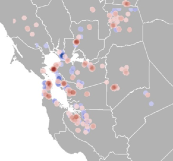
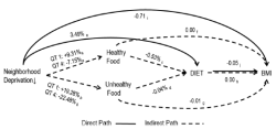
In previous research, neighborhood deprivation was positively associated with body mass index (BMI) among adults with diabetes. We assessed whether the association between neighborhood deprivation and BMI is attributable, in part, to geographic variation in the availability of healthful and unhealthful food vendors. Subjects were 16,634 participants of the Diabetes Study of Northern California. Neighborhood deprivation and healthful (supermarket and produce) and unhealthful (fast food outlets and convenience stores) food vendor kernel density were calculated at each participant's residential block centroid. Availability of food vendors, both healthful and unhealthful, did not appear to explain the association between neighborhood deprivation and BMI in this population of adults with diabetes.

Click to read more ...

Tuesday
Dec092014

Spatial pattern of BMI among adults in Northern California 

Laraia, B. A., S. D. Blanchard, A. J. Karter, J. C. Jones-Smith, M. Warton, E. Kersten, M. Jerrett, H. H. Moffet, N. Adler, D. Schillinger, and M. Kelly. 2014. Spatial pattern of Body Mass Index among adults in the Diabetes Study of Northern California (DISTANCE). International Journal of Health Geographics 13:48 doi:10.1186/1476-072X-13-48

clustering of high and low BMIThe role that environmental factors, such as neighborhood socioeconomics, food, and physical environment, play in the risk of obesity and chronic diseases is not well quantified. Understanding how spatial distribution of disease risk factors overlap with that of environmental (contextual) characteristics may inform health interventions and policies aimed at reducing the environment risk factors.

Click to read more ...

Wednesday
Nov162011

Mapping downed logs with lidar + obia

downed logs in redBlanchard, S., M. Jakubowski, and M. Kelly. 2011. Object-based image analysis of downed logs in a disturbed forest landscape using lidar. Remote Sensing 3(11): 2420-2439.

Downed logs on the forest floor provide habitat for species, fuel for forest fires, and function as a key component of forest nutrient cycling and carbon storage. This study evaluates the utility of discrete, multiple return airborne lidar-derived data for image object segmentation and classification of downed logs in a disturbed forested landscape and the efficiency of rule-based object-based image analysis (OBIA) and classification algorithms.

Click to read more ...

Thursday
Oct202011

Use of obia in public health - a review, and call for more

Kelly M., S. Blanchard. E. Kersten and K. Koy. 2011. Object-based analysis of imagery in support of public health: new avenues of research. Remote Sensing 3:2321-2345

The benefits of terrestrial remote sensing in the environmental sciences are clear across a range of applications, and increasingly remote sensing analyses are being integrated into public health research. This integration has largely been in two areas: first, through the inclusion of continuous remote sensing products such as normalized difference vegetation index (NDVI) or moisture indices to answer large-area questions associated with the epidemiology of vector-borne diseases or other health exposures; and second, through image classification to map discrete landscape patches that provide habitat to disease-vectors or that promote poor health. In this second arena, new improvements in object-based image analysis (or “OBIA”) can provide advantages for public health research. This paper provides a brief review of what has been done in the public health literature with continuous and discrete mapping, and then highlights the key concepts in OBIA that could be more of use to public health researchers interested in integrating remote sensing into their work.

Click to read more ...