publications by year

Selected Publications

My CV can be found here, my Google Scholar page is here and my Research Gate page is here. Links to directly downloadable papers are provided when possible - these are for individual use only; links to journals are also provided, but might not be available to users without campus library access. All papers are available upon request.

Entries in faith kearns (5)

Friday
Oct312008

OBIA for classifying urban environments for fire management

Cleve, C., M. Kelly F. Kearns and M. Moritz. 2008. Classification of urban environments for fire management support: A comparison of pixel- and object-based classifications using high-resolution aerial photography. Computers, Environment and Urban Systems 32: 317–326

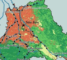
We explore the accuracy of pixel-based and object-based classification methods used for mapping in the wildland–urban interface (WUI) with free, readily available, high spatial resolution urban imagery, which is available in many places to municipal and local fire management agencies. Results indicate that an object-based classification approach provides a higher accuracy than a pixel-based classification approach when distinguishing between the selected land-use and land-cover categories. Pdf download. Journal link.

Keywords: Wildland–urban interface . Classification . Image analysis . Object-based methods . Remote sensing

Friday
Aug312007

Web‐based participatory research informatics

Pederson et al. 2007. Ecological Informatics. Scientific datasets are often generated and used by “communities”, or groups of users and creators. Here we describe a system for promoting collaboration in the creation, maintenance, and use of dynamic data over the web.

Click to read more ...

Sunday
Jul312005

Landscape metrics in freshwater research and management

Kearns et al. 2005. Landscape Ecology. A portion of the study area around San Jose, CAWe quantified landscape composition and configuration for subwatershed areas upstream of individual sampling sites, reducing the number of metrics based on: (1) sensitivity to changes in extent and (2) redundancy, as determined by a multivariate factor analysis.

Click to read more ...

Friday
Dec312004

Geospatial informatics for management of Sudden Oak Death

Kelly, et al. 2004. Photogrammetric Engineering and Remote Sensing. For a geographer viewing the early days of the SOD epidemic, there were several intriguing spatial aspects on which a monitoring system could be built, including: 1) disease impact was clearly visible at multiple spatial scales, making remote sensing useful in the monitoring process; 2) disease spread and consequent mortality were patchy at landscape scales, making spatial analysis useful; 3) the disease appeared to be spatially regulated, making accurate spatial data collected using GPS and maintained and mapped using GIS critical; and 4) public awareness and concern about the disease were high, and public participation was needed in the monitoring/tracking process, making webGIS and cartography immediately useful tools for information distribution and management assistance.

Click to read more ...

Wednesday
Dec312003

webGIS as a tool for sustainable natural resource management

Kearns et al. 2003. Frontiers in Ecology and the Environment. Whether tracking invasive species, assessing water quality, or monitoring the spread of disease, comprehensive data collection is a key component of sustainable natural resource management. Increasingly, fostering community-based monitoring is seen as a valuable way to augment data gathering and enhance public involvement in environmental management.

Click to read more ...