The HyspIRI sensor for wetland observation
Turpie, K R, V V Klemas, K Byrd, M Kelly and Y Lo. 2015. Prospective HyspIRI global observations of tidal wetlands Remote Sensing of Environment, 16: 206-217
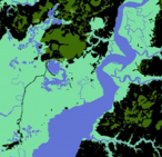 Tidal wetlands are highly productive and act as critical habitat for a wide variety of plants, fish, shellfish, and other wildlife. These ecotones between aquatic and terrestrial environments also provide protection from storm damage, run-off filtering, and recharge of aquifers. Many wetlands along coasts have been exposed to stress-inducing alterations globally, including dredge and fill operations, hydrologic modifications, pollutants, impoundments, fragmentation by roads/ditches, and sea level rise. For wetland protection and sensible coastal development, there is a need to monitor these ecosystems at global and regional scales. Recent advances in satellite sensor design and data analysis are providing practical methods for monitoring natural and man-made changes in wetlands. However, available satellite remote sensors have been limited to mapping primarily wetland location and extent. This paper describes how the HyspIRI hyperspectral and thermal infrared sensors can be used to study and map key ecological properties, such as species composition, biomass, hydrology, and evapotranspiration of tidal salt and brackish marshes and mangroves, and perhaps other major wetland types, including freshwater marshes and wooded/shrub wetlands. Journal Link.
 remote sensing