blog authors
past blog entries

Welcome to the Kellylab blog

geospatial matters

Please read the UC Berkeley Computer Use Policy. Only members can post comments on this blog.

Entries in art (27)

Tuesday
Jan192016

GIF & IGIS from space

Made this for fun for the GIF & IGIS from NASA's "abcs from space" site: http://earthobservatory.nasa.gov/Features/ABC/. Was going to do "Kellylab" but ran out of time.

  • G: This image of Pinaki Island was captured by astronauts on the International Space Station in April 2001.
  • I: On February 10, 2007, the Moderate Resolution Imaging Spectroradiometer (MODIS) on NASA’s Terra satellite captured this image of the Andaman Islands. The thin, bright rings surrounding several of the islands are coral reefs that were lifted up by a massive earthquake near Sumatra in 2004.
  • F: The Operational Land Imager (OLI) on Landsat 8 acquired this false-color image of valleys and snow-covered mountain ranges in southeastern Tibet on August 4, 2014. Firn is a granular type of snow often found on the surface of a glacier before it has been compressed into ice.

  • I: On February 10, 2007, the Moderate Resolution Imaging Spectroradiometer (MODIS) on NASA’s Terra satellite captured this image of the Andaman Islands. The thin, bright rings surrounding several of the islands are coral reefs that were lifted up by a massive earthquake near Sumatra in 2004.
  • G: This image of Pinaki Island was captured by astronauts on the International Space Station in April 2001.
  • S: On April 29, 2009, the Moderate Resolution Imaging Spectroradiometer (MODIS) on the Terra satellite acquired this image of clouds swirling over the Atlantic Ocean.
Sunday
Dec202015

Wolf Hall meets GIS: Mapping musings for the holidays

The great Mark Rylance in character of Thomas Cromwell, from the BBC. I realize this is not the real Cromwell, but Rylance is way easier on the eyes.There are so many reasons I keep returning to Hilary Mantel's Wolf Hall. The book to me seems infinitely revealing, I keep hearing new details. I also managed to use a quote from the book's dialogue in a faculty meeting this year, so there. She comments on history, art, science, collaboration, violence, power, love, politics, craft, cooking, and family. And of course, also mapping. Maps are mentioned many times through the book. At the end, Mantel has Thomas Cromwell say:

"But the trouble is, maps are always last year's. England is always remaking herself, her cliffs eroding, her sandbanks drifting, springs bubbling up in dead ground. They regroup themselves while we sleep, the landscapes through which we move..."

Lovely stuff! and a great holiday read (or re-read, or re-listen). It reminds us that mapping is a continual effort, a continuous process. All that we map changes: crops are harvested and fields are replanted, cities evolve, forests burn and re-grow, and people move across the face of the earth leaving traces. Our task is to capture in virtual space the key functional elements of space and time - through maps, through spectral reflectance and lidar, through text and discussions - so that we can find answers to to the key questions facing society today. It can also be very personal effort: mapping is mostly concerned with finding the best way to represent and describe a landscape or process that we love and want to understand better. 

Excerpt From: Mantel, Hilary. Wolf Hall. Henry Holt and Company, 2009. iBooks.

Wednesday
Nov112015

Honorary Geographer Maya Lin

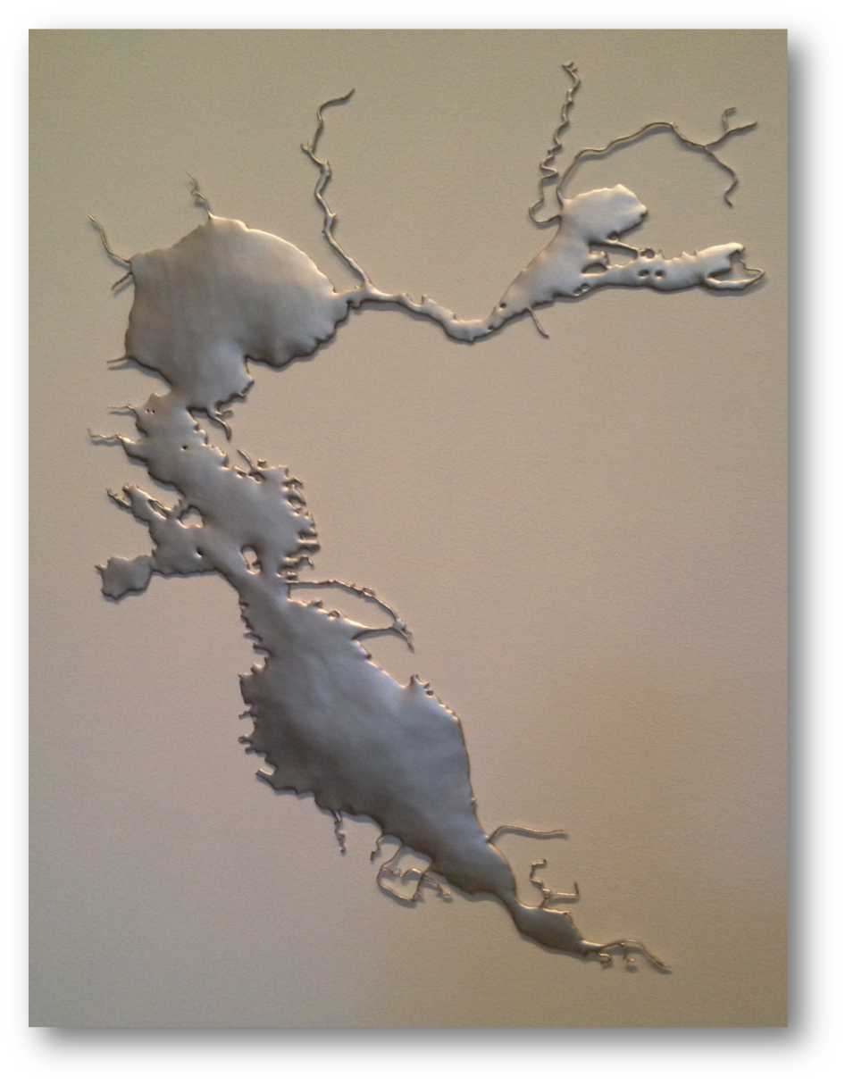
When entertaining out of town visitors in the Bay Area you have a bounty of choices. Many years ago I took visitors to SFMOMA and stumbled into a Maya Lin exhibit. It blew my mind, and I've been a fan ever since. (I've even invited her to give a geolunch talk, but alas it has not happened.) At that time, I had no idea she was the the designer of the Vietnam Veterans Memorial in Washington, D.C., which I found to be a sublime work of reverance. She makes art with strong clear forms that echo the earth. I think what she does resonates with me so much because the idea of spatial representation of geographic form is for me the heart of all we do in science, yet it allows for deep and immediate understanding of place. Whenever I see one of her pieces, I "get" it very quickly, and always feel a little bit happier. Art, what can you say. 

Maya Lin: SF Bay @ Brower CenterShe had a small installation recently in the Brower Center in Berkeley. It was lovely. I can't find it on her website, so you will have to trust this. I include one picture here at left.  It is a representation of the Bay, made in some kind of metal, mounted flush on the wall.  In the same show she had a model of the Sacramento River made from silver stick pins, also mounted on the wall - very fluid and playful with light. I use a slide of her model of the SF Bay shown here as an into into my lectures on modeling (also a shot of the weird and wonderful SF Bay model in Sausalito, more about that anon). 
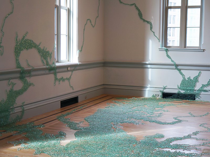
Her most recent work at the Smithsonian's newly renovated Renwick Gallery uses green marbles to model the Chesapeake Bay. It is a stunning piece, I wish I could be there. I read about the work here.  
Maya Lin: Chesapeake Bay, Smithsonian
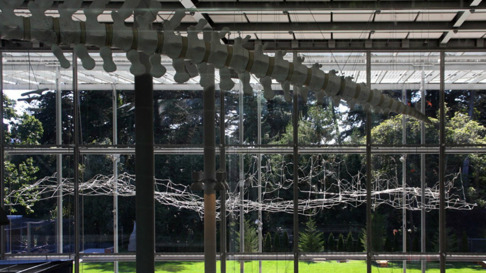
Her description of a recent (2008) installation at the California Academy of Sciences in SF "Where the Land Meets the Sea" says: "By using science and technology in her artwork to create new ways of looking at the environment, Maya Lin's work inspires viewers to pay closer attention to the natural world." I think that is true, but it is also true that it is pleasing because it is so apart from the natural world and yet so resonant with it. If that makes any sense. The work is below:
Maya Lin's Where the Land Meets the Sea at Cal Academy in 2008
In that piece (picture above) modeling the shape of the SF Bay, the terrain (or bathymetry) is based on data supplied by the U.S. Geological Survey, among others, and represents a 1:700 scale with a vertical exaggeration of 5 times above sea level and 10 times below. Sea level is 18 feet above the terrace.
Looking forward to seeing more of her work, in person if possible. 


Friday
Dec192014

The mapping process: musings at the end of 2014

Here are some evocative words about mapping from an unlikely source: in her astounding and engrossing book Wolf Hall, Hilary Mantel has Thomas Cromwell say:

But the trouble is, maps are always last year's. England is always remaking herself, her cliffs eroding, her sandbanks drifting, springs bubbling up in dead ground. They regroup themselves while we sleep, the landscapes through which we move..."

Lovely stuff! and a great holiday read (or re-read, or re-listen). It reminds us that mapping is a continual effort, a continuous process. All that we map changes: crops are harvested and fields are replanted, cities evolve, forests burn and re-grow, and people move across the face of the earth leaving traces. Our task is to capture in virtual space the key functional elements of space and time - through maps, through spectral reflectance and lidar, through text and discussions - so that we can find answers to to the key questions facing society today.

Excerpt From: Mantel, Hilary. Wolf Hall. Henry Holt and Company, 2009. iBooks.

Saturday
Jul052014

Flight visualization

Monday
Oct212013

The art of remote sensing: Van Gogh in Space via Landsat

This image is making the rounds on social media, and it is a beaut. The Landsat program calls this one "Van Gogh from Space" - It was imaged July 13th, 2005. 

In the style of Van Gogh's painting "Starry Night," massive congregations of greenish phytoplankton swirl in the dark water around Gotland, a Swedish island in the Baltic Sea.In a recent paper by Michael Wulder and others discuss the tremendous benefits of the Landsat program on numerous scientific disciplines, and the overwhelming benefits to science of open access to the Landsat archive.

"Landsat occupies a unique position in the constellation of civilian earth observation satellites, with a long and rich scientific and applications heritage. With nearly 40 years of continuous observation – since launch of the first satellite in 1972 – the Landsat program has benefited from insightful technical specification, robust engineering, and the necessary infrastructure for data archive and dissemination. Chiefly, the spatial and spectral resolutions have proven of broad utility and have remained largely stable over the life of the program. The foresighted acquisition and maintenance of a global image archive has proven to be of unmatched value, providing a window into the past and fueling the monitoring and modeling of global land cover and ecological change."

Reference: Wulder, M.A.; Masek, J.G.; Cohen, W.B.; Loveland, T.R.; Woodcock, C.E. Opening the archive: How free data has enabled the science and monitoring promise of Landsat. Remote Sensing of Environment 2012,122, 2-10

Monday
Nov262012

A great week for radio

What a great week for radio and matters geospatial+web. On Wednesday last week we finished out our GIS class with a talk about the geoweb and issues of access, bias, motivation, control, and of course privacy. I used alot of William Gibson's previous writings about Google (posted here earlier) in that lecture. Yesterday TTBOOK re-aired a great interview with Gibson, on the topic of writing, but also about the internet. I recommend it. Additionally, last week Talk of the Nation had a interesting interview with Jerry Brotton about his new book "A History of the World in Twelve Maps"; the interview touched on Google Earth and representation, why north is up, and many other fantastic questions raised through the history of cartography. Check them out!

Monday
Oct152012

Aerial photography highlighted on new US Forever Stamps

Check out some of the gorgeous imagery that will be featured on a new series of US stamps. NASA imagery is highlighted, and the South Bay Salt ponds are featured on one stamp (see below). From the US Postal Service:

"Depicting America’s diverse landscapes on photos taken from ultra lights to satellites, the Earthscapes stamps provide a view of the nation’s diverse landscapes in a whole new way — from heights ranging from several hundred feet above the earth to several hundred miles in space.

south bay salt pondsThe stamps provide an opportunity to see the world in a new way by presenting examples of three categories of earthscapes: natural, agricultural, and urban. The photographs were all taken high above the planet’s surface, either snapped by satellites orbiting the Earth or carefully composed by photographers in aircraft. Howard E. Paine of Delaplane, VA, was the art director."


Tuesday
Feb142012

Happy Valentine's Day People!

Here is the famous mangrove heart from Yann Arthhus-Bertrand's Earth From Above project. Which now lets you download imagery for free. And if you need more, here is a collection of random (and mostly vegetated) hearts from above.

Tuesday
Feb072012

New blue marble: history of its development on video 

Recently, NASA released a new Blue Marble graphic, from sensors aboard TERRA. The Talk of the Nation Science Friday video of the week tells the story of these NASA's Blue Marble maps.  From the Apollo 8 crew's image from 1968, to the Apollo 17 mission of 1972, through the Voyager image, through modern remote sensing techniques, to 2002's original Blue Marble image (now used as the default background on the iphone), to this new release. They highlight the work of Rob Simmon and Gene Feldman, who discuss the composition of the product, highlighting the art that goes into the scientific product. Very cool! More discussion here.