blog authors
past blog entries

Welcome to the Kellylab blog

geospatial matters

Please read the UC Berkeley Computer Use Policy. Only members can post comments on this blog.

Entries in accuracy (4)

Sunday
Jul312016

New datum for Australia: catch me if you can!

In the US, we have revised our geodetic datum over the yearrs. Most famously the switch from NAD27 to NAD83 as instrumention necessitated more measurements and resulted in a more accurate model. But in Australia, they are creating a new datum because the continent is MOVING 7cm a year. 

Read here: http://www.bbc.com/news/technology-36912700

Check it:

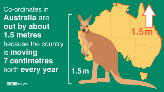
The Geocentric Datum of Australia, the country's local co-ordinate system, was last updated in 1994. Since then, Australia has moved about 1.5 metres north.

So on 1 January 2017, the country's local co-ordinates will also be shifted further north - by 1.8m.

The over-correction means Australia's local co-ordinates and the Earth's global co-ordinates will align in 2020.

Tuesday
Nov102015

National Park moved 150 miles to the east to take up role as urban escape

Here is a funny response to a major map error on Google Maps, found last month. From BBC Wales: http://www.bbc.com/news/uk-wales-mid-wales-34410736

The gorgeous Brecon Beacons was erroneously positioned outside of downtown London. The technical error has directed people searching for the national park more than 150m (241km) away to a location between Chelsea and Knightsbridge.

Brecon Beacons National Park Authority posted the image online with the caption: "We have now moved. Londoners get an upgrade thanks to Google Maps."

Chief executive John Cook joked: "Well the move has come as a bit of a shock to us all."

He added: "I'm sure it will come as good news to Londoners who want some fresh mountain air on their doorstep.

"The truth is we are only three hours away from London - don't rely on your sat-nav or Google Maps - just head to Bristol on the M4, cross the bridge, ask a local and they'll know exactly where to find us."

Hilarious response. I've been walking on the Beacons exactly once, and it was divine. 

Wednesday
Sep022015

False precision in the English Lidar release

Great commentary from Martin Isenburgon of LASTools fame on releasing data with false precision. This deals with the new open data release by the Environment Agency in England. So far LiDAR-derived DTM and DSM rasters have been released for 72% of the entire English territory at horizontal resolutions of 50 cm, 1 m, and 2 m. They can be downloaded here. The rasters are distributed as zipped archives of tiles in textual ASC format (*.asc). 

Martin gives us a cautionary tale on how not to release national data. It is not the ASC format that he has problems with, but the vertical precision. He says:

"The vertical resolution ranges from femtometers to attometers. This means that the ASCII numbers that specify the elevation for each grid cell are written down with 15 to 17 digits after the decimal point."

Example heights might be something like: 79.9499969482421875 or 80.23999786376953125. These data should be resolved to about the cm, not attometer, whatever that is. Crazy man!

Read the full post: http://rapidlasso.com/2015/09/02/england-releases-national-lidar-dem-with-insane-vertical-resolution/

Saturday
Nov062010

Google Maps border becomes part of international dispute

(CNN) -- The accuracy of Google Maps has been pulled into a debate about the border between two Central American countries.

A Nicaraguan general cited Google's version of the border map as an after-the-fact justification of a reported raid of a disputed area between that country and Costa Rica.

http://www.cnn.com/2010/TECH/web/11/05/nicaragua.raid.google.maps/index.html