blog authors
past blog entries

Welcome to the Kellylab blog

geospatial matters

Please read the UC Berkeley Computer Use Policy. Only members can post comments on this blog.

Entries in fire (29)

Tuesday
Mar082016

LandFire is looking for field data! Add yours now. 

I wanted to send out a friendly reminder that the data submission deadline for the current data call is March 31, 2016.  Data submitted before March 31 are evaluated for inclusion in the appropriate update cycle, and submissions after March 31 are typically considered in subsequent updates.  

This is the last call for vegetation/fuel plot data that can be used for the upcoming LANDFIRE Remap. If you have any plot data you would like to contribute please submit the data by March 31 in order to guarantee the data will be evaluated for inclusion in the LF2015 Remap. LANDFIRE is also accepting contributions of polygon data from 2015/2016 for disturbance and treatment activities. Please see the attached data call letter for more information.

Brenda Lundberg, Senior Scientist

Stinger Ghaffarian Technologies (SGT, Inc.)

Contractor to the U.S. Geological Survey (USGS)

Earth Resources Observation & Science (EROS) Center

Phone: 406.329.3405

Email: blundberg@usgs.gov

Wednesday
Sep162015

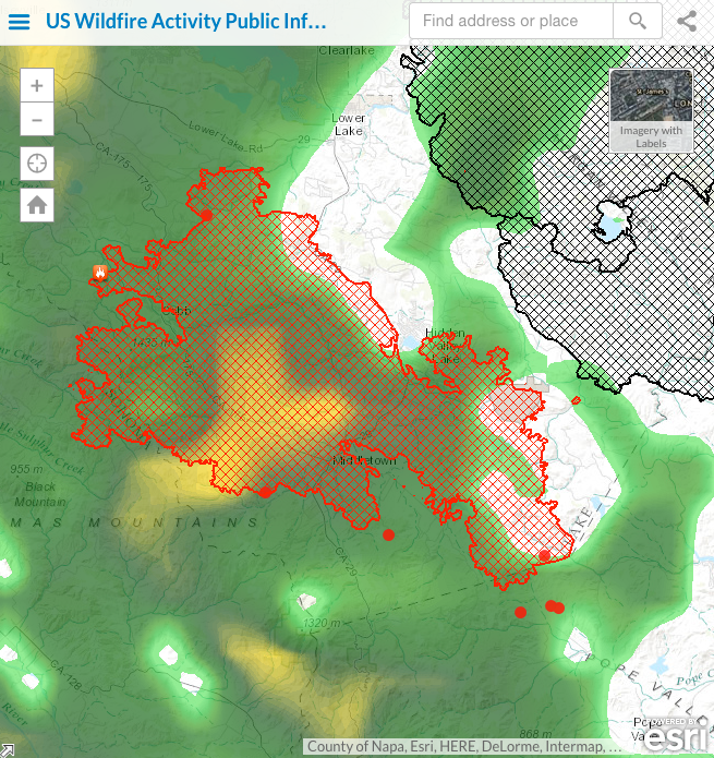
It is raining on the Valley Fire, thank goodness

Been addicted to the ESRI fire feed for its integration of numerous data sources. 

Here is the Valley Fire currently, and the rain that just hit us has moved north. 

For more: http://www.esri.com/services/disaster-response/wildlandfire/latest-news-map

Wednesday
Oct292014

King fire burn severity

The King Fire is out, but it leaves us with alot to ponder. It started September 13 and quickly jumped on a northward run through National Forest and private forestlands. At the end, it burned 97,717 acres. 12 houses and several other minor structures were lost. More worrying is the fact that it burned through many California Spotted Owl PACs in the Eldorado National Forest. We are waiting to hear from the SNAMP Owl team on what their assessment of the situation is. In the meantime, here is a map of burn severity for the fire, made by Stefania from data from the USFS. Clearly it burned hot.

Friday
Sep192014

King fire update

Blodgett looks like it is going to be OK, but the King fire is burning through the SNAMP Eldorado study area. This is where the SNAMP owl reasearchers are doing their work. We are getting a response from them to post on the SNAMP website.

Center for Forestry map of the King Fire

Inciweb (why don't they publish the fire boundary file any more????)

Carlin Starrs gets her perimeters from http://ftpinfo.nifc.gov/

Geomac - http://www.geomac.gov/asp-bin/GeoMACKML/getKML.aspx

and the NIFC FTP server at ftp://ftp.nifc.gov/Incident_Specific_Data/CALIF_N/!2014_FEDERAL_Incidents/CA-ENF-023461_King/IR/

We will keep our eyes on it.

And Happy 100th Anniversary Berkeley Forestry!

Tuesday
Sep162014

King fire near Blodgett Forest Research Station

From UC Center for Forestry.

9/16 16:30 - The King Fire started the evening of September 13 east of Pollock Pines. On 9/15, it grew to 3,900 acres. By the morning of 9/16, it was over 11,000 acres and 5% contained. 

As of the afternoon of the 16th, the fire is alarmingly close to Blodgett Forest Research Station. All staff are being evacuated.

We will provide updates here as they come in. We anticipate the perimeter update will be updated every 24 hours in the early morning (as the data becomes available).

The last update was 9/16 at 10:00AM.

EVACUATION INFORMATION CAN BE FOUND HERE http://inciweb.nwcg.gov/incident/4108/

For questions, please contact carlinstarrs@berkeley.edu

For more information visit: 

Tuesday
Sep092014

Meadow fire update, burning in Little Yosemite Valley

It's now on Inciweb. The Meadow fire is burning near Yosemite, at the east of Little Yosemite Valley.

From Yosemite NP:

As of 11-9:

The Meadow Fire has progressed rapidly and in multiple directions. In order to maintain the safety of park visitors and allow fire management operations to continue unimpeded, the Superintendent of Yosemite National Park is designating a portion of Yosemite Wilderness as closed. The area will be closed until further notice is given.

As of 11-8:

"Meadow (37 42.738 x 119 30.541 – Mariposa Co., 7,870’, August 16) A fire, that may be a spot fire, from the Meadow lightning-caused fire, was discovered at approximately 12:30 PM, Sunday September 7. The fire is approximately 2,582 acres. It is burning within the Little Yosemite Valley (LYV) on both sides of the Merced River. All trails in the area are closed. Approximately 100 hikers and backpackers were evacuated from the fire area in LYV. The fire is burning in Yosemite Wilderness. The High Sierra Camps were seasonally closed today."

Scott Stephens says it is growing fast. We will keep our eyes on it.

Saturday
Apr052014

Sierra Nevada Decision Support System

Former student and GIS expert Chippie Kislik alerted me to this video. She is working with others at NASA Ames on a Sierra Nevada DSS Ecological Forecasting Project. A video about the project is here.

The Sierra Nevada contains vital ecosystems that are experiencing changes in hydrologic regimes, such as decreases in snowmelt and peak runoff, which affect forest health and water resources. Currently, the U.S. Forest Service Region 5 office is undergoing Forest Plan revisions to integrate climate-change impacts into mitigation and adaptation strategies. However, there are few tools in place to conduct quantitative assessments of forest and surface conditions in relation to mountain hydrology, while easily and effectively delivering that information to forest managers. To assist the Forest Service, this research team created a Decision Support System (DSS) featuring data integration, data viewing, reporting, and forecasting of ecological conditions within all Sierra Nevada intersecting watersheds.

Monday
Nov042013

How does the USFS map vegetation post fires? 

The discussion of how the USFS deals with fires on public forests came up strongly in our recent SNAMP Public Meeting. Our Last Change field site burned in October, and we are very interested in understanding the behavior and impact of the American fire. Part of the discussion stemmed from this presentation on preliminary estimates for fire intensity, ascertained partly from analysis of WorldView imagery delivered at our SNAMP meeting. For more on the SNAMP presentation, check out our website.

The website (linked below) offers an initial description of post-fire vegetative conditions using the Rapid Assessment of Vegetation Condition after Wildfire (RAVG) process. RAVG analysis looks at fires that burn more than 1,000 acres of forested National Forest System (NFS) lands, beginning with fires that occurred in 2007. These fires result in direct losses of vegetative cover and many of the benefits associated with forested ecosystems.

NFS lands experience thousands of wildfires every year, most of which are relatively small. The largest fires typically account for 90% of the total acreage burned. RAVG analysis provides a first approximation of areas that due to severity of the fire may require reforestation treatments. These reforestation treatments would re-establish forest cover and restore associated ecosystem services. This initial approximation could be followed by a site-specific diagnosis and development of a silvicultural prescription identifying reforestation needs.

Some resources:


Wednesday
Oct232013

FUEGO — A concept for a fire detection satellite

A nice press release about our new paper on the concepts behind a fire detection satellite with perhaps the coolest acronym yet: FUEGO — Fire Urgency Estimator in Geosynchronous Orbit. From Bob Sanders.

Artist's conception of the FUEGO satellite

Current and planned wildfire detection systems are impressive but lack both sensitivity and rapid response times. A small telescope with modern detectors and significant computing capacity in geosynchronous orbit can detect small (12 m2) fires on the surface of the earth, cover most of the western United States (under conditions of moderately clear skies) every few minutes or so, and attain very good signal-to-noise ratio against Poisson fluctuations in a second. Hence, these favorable statistical significances have initiated a study of how such a satellite could operate and reject the large number of expected systematic false alarms from a number of sources. We suggest a number of algorithms that can help reduce false alarms, and show efficacy on a few. Early detection and response would be of true value in the United States and other nations, as wildland fires continue to severely stress resource managers, policy makers, and the public, particularly in the western US. Here, we propose the framework for a geosynchronous satellite with modern imaging detectors, software, and algorithms able to detect heat from early and small fires, and yield minute-scale detection times. Open Access Journal Link. Press Release. KPIX spot.

Tuesday
Oct222013

Post American fire imagery

Check out these images from after the American fire, from the WorldView 2 satelllite from our northern SNAMP site. The blue boundary is our SNAMP site.  This background imagery is a pan-sharpened WV2 image (0.5 meters, channels 7, 5, 3). The red color depicts alive vegetation (at least for the time being) and green-blue is post-fire NPV (non-photosynthetic veg).  Thanks to Carlos Ramirez for the images.

 The post-fire imagery shows the heterogeneity of this fire - some spots burned all the vegetation, some spots have standing trees remaining.