A new tool for finding old maps: USGS topoView

Get your topo maps!
The USGS recently unvieled a new, extremely easy and enviably sleek web mapping interface to search and download nearly 178,000 topographical maps, dating from 1880 to 2010.
geospatial matters
Please read the UC Berkeley Computer Use Policy. Only members can post comments on this blog.
Get your topo maps!
The USGS recently unvieled a new, extremely easy and enviably sleek web mapping interface to search and download nearly 178,000 topographical maps, dating from 1880 to 2010.
Last week Kelly and I with others travelled to the Sierra Nevada Aquatic Research Lab (SNARL) in the eastern Sierra Nevada, just south of Mono Lake for a research retreat. SNARL is part of the UC's Natural Reserve System, which is comprised of nearly 40 properties across the state. These are preserves that foster research, education and collaboration. They have much in common with ANR's REC system. I've been to a few of them now, and am very pleased to make more visits. I love the east side of the Sierra, and that iconic Highway 395.
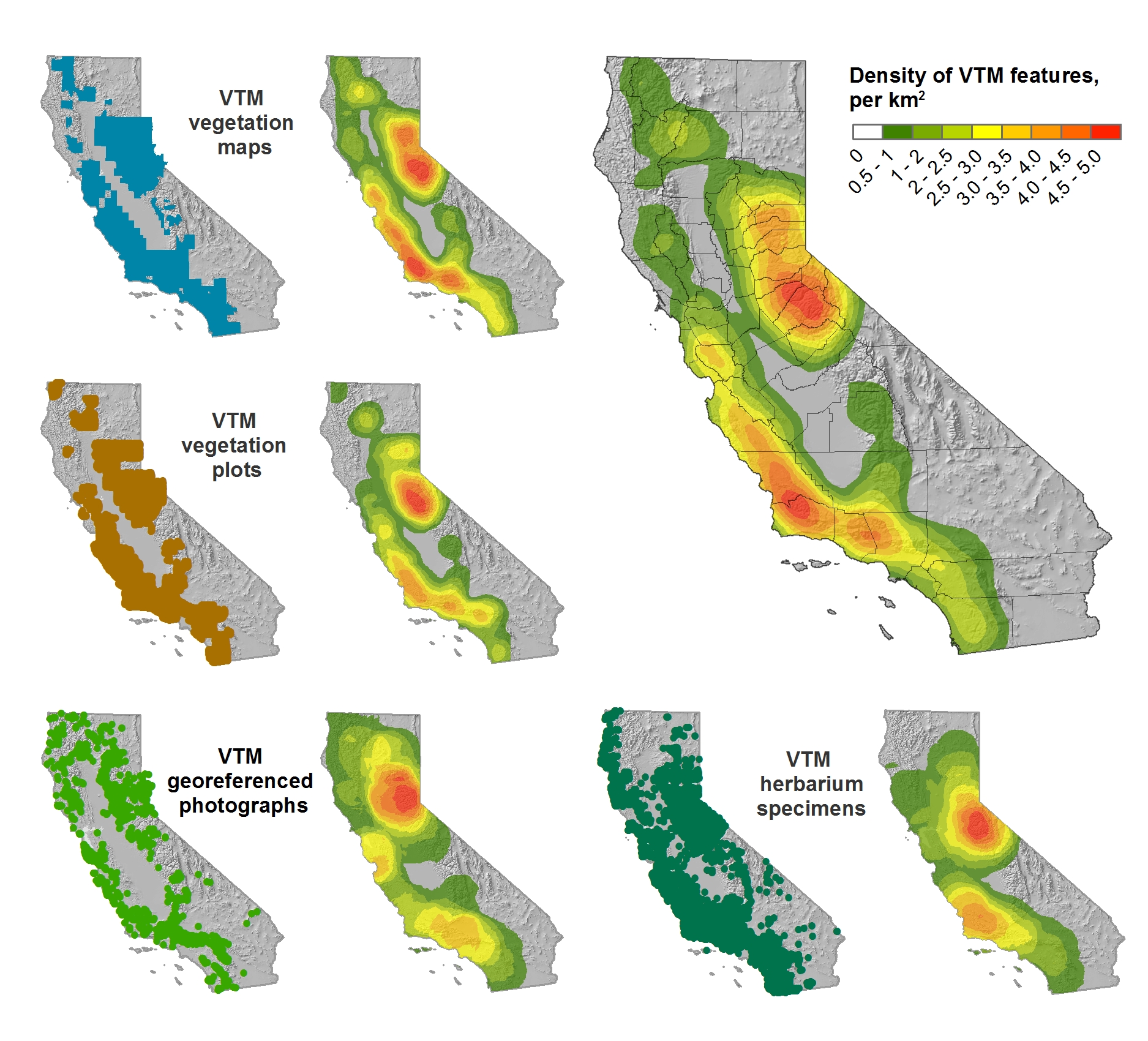
This trip was a retreat for the ISECCI historical ecology working group, led by the inspirational Peter Alagona from UCSB. We discussed our existing projects, including the VTM work (see figure below), and talked about potentials for more collaborative research and further integration between NRS and ANR. We have a list of wishes for digitization, and if anyone out there has ideas about pitching these to donors, please let me know. For example:
And we had a field trip looking at Mono Lake water issues. Great time spent!
Density of VTM features across the collections
I wanted to send out a friendly reminder that the data submission deadline for the current data call is March 31, 2016. Data submitted before March 31 are evaluated for inclusion in the appropriate update cycle, and submissions after March 31 are typically considered in subsequent updates.
This is the last call for vegetation/fuel plot data that can be used for the upcoming LANDFIRE Remap. If you have any plot data you would like to contribute please submit the data by March 31 in order to guarantee the data will be evaluated for inclusion in the LF2015 Remap. LANDFIRE is also accepting contributions of polygon data from 2015/2016 for disturbance and treatment activities. Please see the attached data call letter for more information.
Brenda Lundberg, Senior Scientist
Stinger Ghaffarian Technologies (SGT, Inc.)
Contractor to the U.S. Geological Survey (USGS)
Earth Resources Observation & Science (EROS) Center
Phone: 406.329.3405
Email: blundberg@usgs.gov
Developing data-driven solutions in the face of rapid global change
Global environmental change poses critical environmental and societal needs, and the next generation of students are part of the future solutions. This National Science Foundation Research Traineeship (NRT) in Data Science for the 21st Century prepares graduate students at the University of California Berkeley with the skills and knowledge needed to evaluate how rapid environmental change impacts human and natural systems and to develop and evaluate data-driven solutions in public policy, resource management, and environmental design that will mitigate negative effects on human well-being and the natural world. Trainees will research topics such as management of water resources, regional land use, and responses of agricultural systems to economic and climate change, and develop skills in data visualization, informatics, software development, and science communication.
In a final semester innovative team-based problem-solving course, trainees will collaborate with an external partner organization to tackle a challenge in global environmental change that includes a significant problem in data analysis and interpretation of impacts and solutions. This collaboration is a fundamental and distinguishing component of the NRT program. We hope this collaboration will not only advance progress on the grand challenges of national and global importance, but also be memorable and useful for the trainees, and for the partners.
An Invitation to Collaborate
We are inviting collaboration with external partners to work with our students on their Team Research Project in 2016-17. Our students would greatly benefit from working with research agencies, non-profits, and industry.
This new NSF funded DS421 program is in the first of 5 years. We look forward to building ongoing collaborations with partners and UC Berkeley.
Parcel data for California summary and download here. http://egis3.lacounty.gov/dataportal/2015/09/11/california-statewide-parcel-boundaries/
The data are not complete. But downloadable in geodatabase format.
"A geodatabase with parcel boundaries for 51 (out of 58) counties in the State of California. The original target was to collect data for the close of the 2013 fiscal year. As the collection progressed, it became clear that holding to that time standard was not practical. Out of expediency, the date requirement was relaxed, and the currently available dataset was collected for a majority of the counties. Most of these were distributed with minimal metadata."
Awesome new (ish?) R package from the gang over at rOpenSci
Tired of searching biodiversity occurance data through individual platforms? The "spocc" package comes to your rescue and allows for a streamlined workflow in the collection and mapping of species occurrence data from range of sites including: GBIF, iNaturalist, Ecoengine, AntWeb, eBird, and USGS's BISON.
There is a caveat however, since the sites use alot of the same repositories the authors of the package caution to check for dulicates. Regardless what a great way to simplify your workflow!
Find the package from CRAN: install.packages("spocc") and read more about it here!
Just got off a call with a group of people focusing on historical data discovery at the Natural Reserve System (NRS). This process is part of the recently funded Institute for the Study of Ecological Effects of Climate Impacts (ISEECI). People in the group include:
Of particular note was the introduction of the Online Archive of California, which is a collection of metadata about historical archives. Peter is adding all his data to the OAC. His work was funded through a Research Opportunity Fund grant through UCOP, and a NSF grant. The process the NRS has used is different than what we have done with the REC data. They have assembled metadata from the research reports from the stations, and full digitization can be opportunisic and focused on particular questions. There is a Zotero database of publications that have resulted from the reserves.
Other important links:
The metadata data from research applications submitted through RAMS - tends to be incomplete as we rely on PI's to proof the entry and then submit it.
http://nrs.ucop.edu/MetaData.htm
The reference database, this has had extensive work done on it, and should be fairly complete. Lynn's working on a complementary database for Santa Cruz Island historic data, which will be made available.
http://nrs.ucop.edu/bibliography.htm
Climate data - currently hosted on DRI's website, and data should be available for download.
I don't use ocean color data, but found this report of interest nonetheless. From the HICO website. HICO is the Hyperspectral Imager for the Coastal Ocean.
HICO Operations Ended. March 20, 2015
In September 2014 during an X-class solar storm, HICO’s computer took a severe radiation hit, from which it never recovered. Over the past several months, engineers at NRL and NASA have attempted to restart the computer and have conducted numerous tests to find alternative pathways to communicate with it. None of these attempts have been successful. So it is with great sadness that we bid a fond farewell to HICO.
Yet we rejoice that HICO performed splendidly for five years, despite being built in only 18 months from non space-hardened, commercial-off-the-shelf parts for a bargain price. Having met all its Navy goals in the first year, HICO was granted a two-year operations extension from the Office of Naval Research and then NASA stepped in to sponsor this ISS-based sensor, extending HICO’s operations another two years. All told, HICO operated for 5 years, during which it collected approximately 10,000 hyperspectral scenes of the earth.
Most of the HICO scenes taken over sites worldwide are available now, and will remain accessible to researchers through two websites: http://oceancolor.gsfc.nasa.gov/ and http://hico.coas.oregonstate.edu. HICO will live on through research conducted by scientists using HICO data, especially studies exploring the complexities of the world’s coastal oceans.
http://www.neoninc.org/data-resources/get-data/airborne-dataFrom LASTools list:
The National Ecological Observatory Network (NEON) published this week airborne remote sensing data including full waveform and discrete return LiDAR data and LiDAR derivatives (DTM, DSM, CHM) as well as corresponding hyperspectral data, orthophotos, and field data on vegetation strucutre, foliar chemistry and ASD field spectra.
NEON Airborne Data Set.
From Sean's IGIS workshops this week.
Base Layers
Land Cover and Wildlife Habitat
Imagery
Soils
Climate and Weather Data
California Geopolitical Boundaries
Digital Elevation Models