blog authors
past blog entries

Welcome to the Kellylab blog

geospatial matters

Please read the UC Berkeley Computer Use Policy. Only members can post comments on this blog.

Entries in Landsat (30)

Friday
Apr012016

ASTER Data Open - No April Fools!

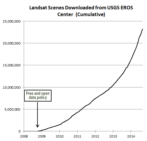
We know about the amazing success for science, education, government, and business that has resulted from the opening of the Landsat archive in 2008. Now more encouraging news about open data:

On April 1, 2016, NASA's Land Processes Distributed Active Archive Center (LP DAAC) began distributing ASTER Level 1 Precision Terrain Corrected Registered At-Sensor Radiance (AST_L1T) data products over the entire globe at no charge. Global distribution of these data at no charge is a result of a policy change made by NASA and Japan.

The AST_L1T product provides a quick turn-around of consistent GIS-ready data as a multi-file product, which includes a HDF-EOS data file, full-resolution composite images (FRI) as GeoTIFFs for tasked telescopes (e.g., VNIR/SWIR and TIR ), and associated metadata files. In addition, each AST_L1T granule contains related products including low-resolution browse and, when applicable, a Quality Assurance (QA) browse and QA text report.

More than 2.95 million scenes of archived data are now available for direct download through the LP DAAC Data Pool and for search and download through NASA‘s Earthdata Search Client and also through USGS‘ GloVis , and USGS‘ EarthExplorer . New scenes will be added as they are acquired and archived.

ASTER is a partnership between NASA, Japan‘s Ministry of Economy, Trade and Industry (METI), the National Institute of Advanced Industrial Science and Technology (AIST) in Japan, and Japan Space Systems (J-spacesystems ).

Visit the LP DAAC ASTER Policy Change Page to learn more about ASTER. Subscribe to the LP DAAC listserv for future announcements.

Tuesday
Jan192016

GIF & IGIS from space

Made this for fun for the GIF & IGIS from NASA's "abcs from space" site: http://earthobservatory.nasa.gov/Features/ABC/. Was going to do "Kellylab" but ran out of time.

  • G: This image of Pinaki Island was captured by astronauts on the International Space Station in April 2001.
  • I: On February 10, 2007, the Moderate Resolution Imaging Spectroradiometer (MODIS) on NASA’s Terra satellite captured this image of the Andaman Islands. The thin, bright rings surrounding several of the islands are coral reefs that were lifted up by a massive earthquake near Sumatra in 2004.
  • F: The Operational Land Imager (OLI) on Landsat 8 acquired this false-color image of valleys and snow-covered mountain ranges in southeastern Tibet on August 4, 2014. Firn is a granular type of snow often found on the surface of a glacier before it has been compressed into ice.

  • I: On February 10, 2007, the Moderate Resolution Imaging Spectroradiometer (MODIS) on NASA’s Terra satellite captured this image of the Andaman Islands. The thin, bright rings surrounding several of the islands are coral reefs that were lifted up by a massive earthquake near Sumatra in 2004.
  • G: This image of Pinaki Island was captured by astronauts on the International Space Station in April 2001.
  • S: On April 29, 2009, the Moderate Resolution Imaging Spectroradiometer (MODIS) on the Terra satellite acquired this image of clouds swirling over the Atlantic Ocean.
Friday
Apr032015

Big data, Landsat and earth science

Saturday
Feb142015

Landsat Seen as Stunning Return on Public Investment 

Undersanding the value of Landsat program to the U.S. economy has been the ambitious goal of the Landsat Advisory Group of the National Geospatial Advisory Committee. This team of commercial, state/local government, and NGO geospatial information experts recently updated a critical review of the value of Landsat information that has recently been released to the public.

They found that the economic value of just one year of Landsat data far exceeds the multi-year total cost of building, launching, and managing Landsat satellites and sensors.  This would be considered a stunning return on investment in any conventional business setting.

Full article by Jon Campbell, U.S. Geological Survey found here.

Tuesday
Apr082014

NLCD released and webinar April 15 2014

These three panels of cyclical data (2001, 2006, 2011) from the National Land Cover Database depict intervals of land cover change in the vicinity of Spring Valley, a suburb of Las Vegas, NV.[Source: USGS] Just released, the latest edition of the nation’s most comprehensive look at land-surface conditions from coast to coast shows the extent of land cover types from forests to urban areas. The National Land Cover Database (NLCD 2011) is made available to the public by the U.S. Geological Survey and partners.

Dividing the lower 48 states into 9 billion geographic cells, the massive database provides consistent information about land conditions at regional to nationwide scales. Collected in repeated five-year cycles, NLCD data is used by resource managers and decision-makers to conduct ecosystem studies, determine spatial patterns of biodiversity, trace indications of climate change, and develop best practices in land management.

Based on Landsat satellite imagery taken in 2011, NLCD 2011 describes the land cover of each 30-meter cell of land in the conterminous United States and identifies which ones have changed since the year 2006. Nearly six such cells — each 98 feet long and wide — would fit on a football field. Land cover is broadly defined as the biophysical pattern of natural vegetation, agriculture, and urban areas. It is shaped by both natural processes and human influences. NLCD 2011 updates the previous database version, NLCD 2006.

Webinar about the release will be Tuesday, April 15, 2014, 2:00 PM Eastern Time: "New Version of the National Land Cover Database - April 4, 2014 Release”

The latest version of the National Land Cover Database (NLCD) for the conterminous United States will be publicly released on April 4, 2014.  NLCD 2011 is the most up-to-date and extensive iteration of the National Land Cover Database, the definitive Landsat-based, 30-meter resolution land cover database for the Nation.  NLCD 2011 products are completely integrated with those of previous versions (2001, 2006), providing a 10-year record of change for the Nation.  Products include 16 classes of land cover, the percent of imperviousness in urban areas, and the percent of tree canopy cover. NLCD is constructed by the 10-member federal interagency Multi-Resolution Land Characteristics (MRLC) Consortium.   This seminar will highlight the new features of NLCD 2011 and the related applicationsCollin Homer, 605-594-2714, homer@usgs.gov)
For more information and to download NLCD data, visit http://www.mrlc.gov/.
Please click the following link to join the webinar:
 https://usgs.webex.com/usgs/j.php?ED=279876177&UID=490357047&RT=MiM3

At start time of the webinar, each location must call one of the dial-in numbers:
From the National Center in Reston, dial internally x4848
From all other USGS/DOI locations, dial 703-648-4848
From non DOI locations, dial toll free 855-547-8255
After the voice prompt, please enter the Conference Security Code 73848024 followed by the # key. You will hear a tone confirming that you have successfully joined the conference call. If you weren't successful, you will hear another voice prompt with instructions.

Tuesday
Mar112014

Google Earth Demo at UCB

Thanks to Dave Thau, Karin Tuxen-Bettman, John Bailey, and Emily Henderson who came to visit the GIF and give a demo of the GEE toolbox. We went over the guts of GEE, Timelapse (very cool: make your own! Here is mine), the GEE GUI framework, and the GEE API. Very fun afternoon!

Friday
Feb142014

Happy Valentine's Day Landsat 8! 

It's meta-gorgeous, and better than spy vs spy: Landsat 8 catches a glimpse of its older, retired uncle Landsat 5. From NASA:

Feb 14, 2014 • Eight months ago, on June 5, 2013, the U.S. Geological Survey decommissioned the venerable Landsat 5 satellite. That day, the USGS Landsat Flight Operations Team transmitted the last command to Landsat 5, effectively terminating the mission and leaving it in a disposal orbit.

This week, Landsat 8 overflew the defunct Landsat 5, and thanks to some clever work by Mike Gartley, a Research Scientist with the Digital Imaging and Remote Sensing group at Rochester Institute of Technology (RIT)—a group that has long participated in Landsat calibration and validation—Landsat 5 was seen in an image taken by Landsat 8.

In these images, the satellite is seen as a streak of pixels (dark or light depending on the spectral band). There is one image from each of Landsat 8′s OLI bands, except for Band 7, or SWIR-2, where she blended into the clouds and was impossible to distinguish. In these images Landsat 5 is much closer to Landsat 8 than she is to the Earth. More here.

Friday
Feb072014

Musings about Robert N. Colwell

I am working on a retrospective of remote sensing of forests in California for the centennial. I am trying to highlight some of the pioneering work done by remote sensors that focused on Californian forests from the 1960s through the use of lidar today.

Oblique aerial view of Berkeley Campus of University of California taken with Camouflage Detection film. Robert N. Colwell

Of course with this topic you must begin with Robert N. Colwell. Dr. Colwell was an internationally renowned remote sensing scientist; he was former associate director of the Space Sciences Laboratory at the UC Berkeley, and he was the instructor of remote sensing in our own Mulford Hall from 1947 until his retirement in 1983. He was NASA co-investigator for Apollo IX, and his research in the 1960s on reflectance and multispectral reconnaissance were the primary basis for selecting the type of sensors and the spectral bands implemented in Landsat. Neat guy, and we all benefit from his intellectual legacy.

Anyway, for this paper, I am going through some of his work as he transitioned from aerial photography to digital imaging, and I came across this picture. Mulford is just off the scene in the upper left corner, and Hearst Gym pool is visible in lower part. In his caption he says:

"Oblique aerial view of Berkeley Campus of University of California taken with Camouflage Detection film." (That is what they used to call color infrared.) "Such photography is superior to any other for certain photo interpretation purposes as indicated by some of the preceding examples. Note in this photo how color values for each species of tree tend to remain uniform from foreground to background because of the superior haze penetration offered by this film. The relatively long wavelengths to which this infrared-sensitive film reacts are scattered but very little by atmospheric haze particles, thus accounting for the uniform color values and for excellent image sharpness." I dig this part: "The original color transparencies have the same color values as seen here and consequently make very attractive panels for lamp shades, although certain of their colors fade upon prolonged exposure to light."

The trend for using map products as kitchy home decorations PRE-DATES 1970! Take that hipsters!

Article source: Colwell, R.N. 1964. Aerial photography - A valuable sensor for the scientist. American Scientist, Vol. 52, No. 1 (MARCH 1964), pp. 16-49

Some more about him here: http://senate.universityofcalifornia.edu/inmemoriam/robertcolwell.htm

Friday
Nov152013

Global forest change from Landsat and Google

The video describing the partnership and the product is available now.

A new high-resolution global map of forest loss and gain has been created with the help of Google Earth. The interactive online tool is publicly available and zooms in to a remarkably high level of local detail - a resolution of 30m. Snapshot of Russia here (green = forest, blue = gain, red = loss):

Russia has much forest activity

Results from time-series analysis of 654,178 Landsat images from 2000–2012 characterize forest extent and change. Between 2000 and 2012, according to this analysis, the Earth lost a combined "forest" the size of Mongolia. http://www.bbc.co.uk/news/science-environment-24934790

Here is the abstract from the accompanying paper in Science:

Quantification of global forest change has been lacking despite the recognized importance of forest ecosystem services. In this study, Earth observation satellite data were used to map global forest loss (2.3 million square kilometers) and gain (0.8 million square kilometers) from 2000 to 2012 at a spatial resolution of 30 meters. The tropics were the only climate domain to exhibit a trend, with forest loss increasing by 2101 square kilometers per year. Brazil’s well-documented reduction in deforestation was offset by increasing forest loss in Indonesia, Malaysia, Paraguay, Bolivia, Zambia, Angola, and elsewhere. Intensive forestry practiced within subtropical forests resulted in the highest rates of forest change globally. Boreal forest loss due largely to fire and forestry was second to that in the tropics in absolute and proportional terms. These results depict a globally consistent and locally relevant record of forest change.

Hansen, M.C.; Potapov, P.V.; Moore, R.; Hancher, M.; Turubanova, S.A.; Tyukavina, A.; Thau, D.; Stehman, S.V.; Goetz, S.J.; Loveland, T.R.; Kommareddy, A.; Egorov, A.; Chini, L.; Justice, C.O.; Townshend, J.R.G. High-Resolution Global Maps of 21st-Century Forest Cover Change. Science 2013, 342, 850-853

Thursday
Nov142013

NASA shares satellite and climate data on Amazon’s cloud


NASA has announced a partnership with Amazon Web Services that the agency hopes will spark wider collaboration on climate research. In an effort that is in some ways parallel to Google's Earth Engine, NASA has uploaded terabytes of data to Amazon's public cloud and made it available to the anyone. 

Three data sets are already up at Amazon. The first is climate change forecast data for the continental United States from NASA Earth Exchange (NEX) climate simulations, scaled down to make them usable outside of a supercomputing environment. The other two are satellite data sets—one from from the US Geological Survey's Landsat, and the other a collection of Moderate Resolution Imaging Spectroradiometer (MODIS) data from NASA's Terra and Aqua Earth remote sensing satellites.

More Here