blog authors
past blog entries

Welcome to the Kellylab blog

geospatial matters

Please read the UC Berkeley Computer Use Policy. Only members can post comments on this blog.

Entries in collaboration (36)

Monday
Aug082016

ISECCI historical ecology working group wrap-up

Last week Kelly and I with others travelled to the Sierra Nevada Aquatic Research Lab (SNARL) in the eastern Sierra Nevada, just south of Mono Lake for a research retreat. SNARL is part of the UC's Natural Reserve System, which is comprised of nearly 40 properties across the state. These are preserves that foster research, education and collaboration. They have much in common with ANR's REC system. I've been to a few of them now, and am very pleased to make more visits. I love the east side of the Sierra, and that iconic Highway 395. 

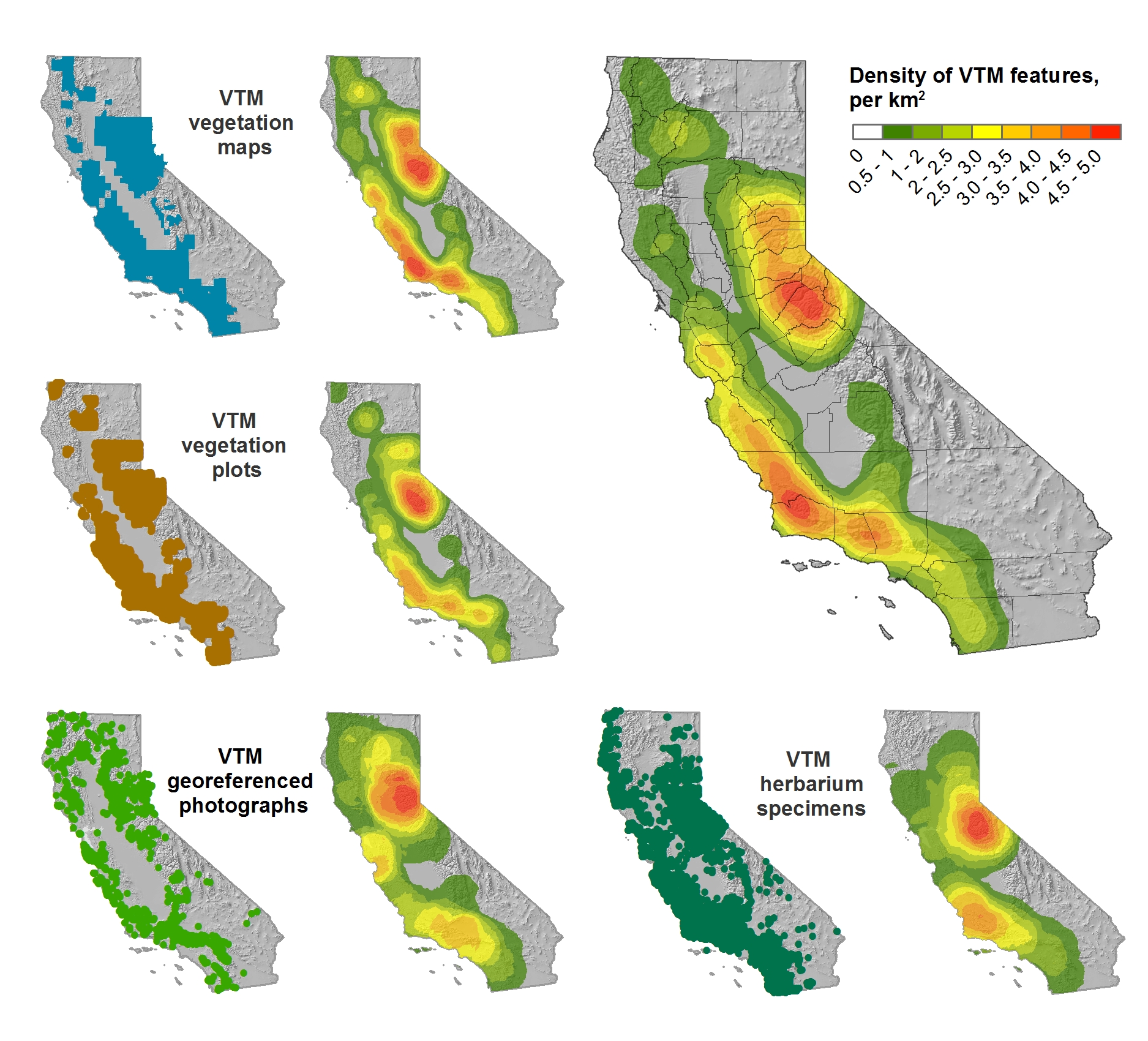
This trip was a retreat for the ISECCI historical ecology working group, led by the inspirational Peter Alagona from UCSB. We discussed our existing projects, including the VTM work (see figure below), and talked about potentials for more collaborative research and further integration between NRS and ANR. We have a list of wishes for digitization, and if anyone out there has ideas about pitching these to donors, please let me know. For example: 

  • Kelly and I want to digitize the Leiburg maps from the northern Sierra to add to the VTM stack;
  • We want to find a better way to index and view historical aerial photography state-wide. Something like this for historical maps: http://ngmdb.usgs.gov/maps/TopoView/help/

And we had a field trip looking at Mono Lake water issues. Great time spent!

Density of VTM features across the collections

Saturday
Apr022016

Spatial Data Science Bootcamp 2016!

Last week we held another bootcamp on Spatial Data Science. We had three packed days learning about the concepts, tools and workflow associated with spatial databases, analysis and visualizations. Our goal was not to teach a specific suite of tools but rather to teach participants how to develop and refine repeatable and testable workflows for spatial data using common standard programming practices.

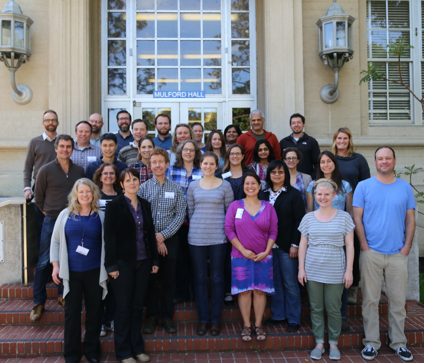
2016 Bootcamp participants

On Day 1 we focused on setting up a collaborative virtual data environment through virtual machines, spatial databases (PostgreSQL/PostGIS) with multi-user editing and versioning (GeoGig). We also talked about open data and open standards, and moderndata formats and tools (GeoJSON, GDAL).  On Day 2 we focused on open analytical tools for spatial data. We focused on Python (i.e. PySAL, NumPy, PyCharm, iPython Notebook), and R tools.  Day 3 was dedicated to the web stack, and visualization via ESRI Online, CartoDB, and Leaflet. Web mapping is great, and as OpenGeo.org says: “Internet maps appear magical: portals into infinitely large, infinitely deep pools of data. But they aren't magical, they are built of a few standard pieces of technology, and the pieces can be re-arranged and sourced from different places.…Anyone can build an internet map."

All-in-all it was a great time spent with a collection of very interesting mapping professionals from around the country. Thanks to everyone!

Tuesday
Mar082016

LandFire is looking for field data! Add yours now. 

I wanted to send out a friendly reminder that the data submission deadline for the current data call is March 31, 2016.  Data submitted before March 31 are evaluated for inclusion in the appropriate update cycle, and submissions after March 31 are typically considered in subsequent updates.  

This is the last call for vegetation/fuel plot data that can be used for the upcoming LANDFIRE Remap. If you have any plot data you would like to contribute please submit the data by March 31 in order to guarantee the data will be evaluated for inclusion in the LF2015 Remap. LANDFIRE is also accepting contributions of polygon data from 2015/2016 for disturbance and treatment activities. Please see the attached data call letter for more information.

Brenda Lundberg, Senior Scientist

Stinger Ghaffarian Technologies (SGT, Inc.)

Contractor to the U.S. Geological Survey (USGS)

Earth Resources Observation & Science (EROS) Center

Phone: 406.329.3405

Email: blundberg@usgs.gov

Tuesday
Jan122016

Spatial Data Science Bootcamp March 2016

Register now for the March 2016 Spatial Data Science Bootcamp at UC Berkeley!

We live in a world where the importance and availability of spatial data are ever increasing. Today’s marketplace needs trained spatial data analysts who can:

  • compile disparate data from multiple sources;
  • use easily available and open technology for robust data analysis, sharing, and publication;
  • apply core spatial analysis methods;
  • and utilize visualization tools to communicate with project managers, the public, and other stakeholders.

To help meet this demand, International and Executive Programs (IEP) and the Geospatial Innovation Facility (GIF) are hosting a 3-day intensive Bootcamp on Spatial Data Science on March 23-25, 2016 at UC Berkeley.

With this Spatial Data Science Bootcamp for professionals, you will learn how to integrate modern Spatial Data Science techniques into your workflow through hands-on exercises that leverage today's latest open source and cloud/web-based technologies. We look forward to seeing you here!

To apply and for more information, please visit the Spatial Data Science Bootcamp website.

Limited space available. Application due on February 19th, 2016.

Tuesday
Jan052016

Our summary from SNAMP: 31 integrated recommendations

The following forest management recommendations consider the SNAMP focal resources (forest, water, wildlife), as well as public participation, as an integrated group. These recommendations were developed by the UC Science Team working together. Although each recommendation was written by one or two authors, the entire team has provided input and critique for the recommendations. The entire UC Science Team endorses all of these integrated management recommendations. Click at the bottom of the post for the full description of each recommendation. 

Section 1: Integrated management recommendations based directly on SNAMP science

Wildfire hazard reduction

1. If your goal is to reduce severity of wildfire effects, SPLATs are an effective means to reduce the severity of wildfires. 

SPLAT impacts on forest ecosystem health 

2. If your goal is to improve forest ecosystem health, SPLATs have a positive effect on tree growth efficiency.

SPLAT impact assessment

3. If your goal is to integrate across firesheds, an accurate vegetation map is essential, and a fusion of optical, lidar and ground data is necessary. 

4. If your goal is to understand the effects of SPLATs, lidar is essential to accurately monitor the intensity and location of SPLAT treatments.

SPLAT impacts on California spotted owl and Pacific fisher

5. If your goal is to maintain existing owl and fisher territories, SPLATs should continue to be placed outside of owl Protected Activity Centers (PACs) and away from fisher den sites, in locations that reduce the risk of high-severity fire occurring within or spreading to those areas.

6. If your goal is to maintain landscape connectivity between spotted owl territories, SPLATs should be implemented in forests with lower canopy cover whenever possible.

7. If your goal is to increase owl nest and fisher den sites, retain oaks and large conifers within SPLAT treatments.

8. If your goal is to maintain fisher habitat quality, retention of canopy cover is a critical consideration.

9. If your goal is to increase fisher foraging activity, limit mastication and implement more post-mastication piling and/or burning to promote a faster recovery of the forest floor condition. 

10. If your goal is to understand SPLAT effects on owl and fisher, it is necessary to consider a larger spatial scale than firesheds.

SPLAT impacts on water quantity and quality

11. If your goal is to detect increases in water yield from forest management, fuel treatments may need to be more intensive than the SPLATs that were implemented in SNAMP.

12. If your goal is to maintain water quality, SPLATs as implemented in SNAMP have no detectable effect on turbidity.

Stakeholder participation in SPLAT implementation and assessment

13. If your goal is to increase acceptance of fuel treatments, employ outreach techniques that include transparency, shared learning, and inclusiveness that lead to relationship building and the ability to work together.

14. If your goal is the increased acceptance of fuel treatments, the public needs to understand the tradeoffs between the impacts of treatments and wildfire.

Successful collaborative adaptive management processes

15. If your goal is to establish a third party adaptive management project with an outside science provider, the project also needs to include an outreach component.

16. If your goal is to develop an engaged and informed public, you need to have a diverse portfolio of outreach methods that includes face to face meetings, surveys, field trips, and web-based information.

17. If your goal is to understand or improve outreach effectiveness, track production, flow, and use of information.

18. If your goal is to engage in collaborative adaptive management at a meaningful management scale, secure reliable long term sources of funding.

19. If your goal is to maintain a successful long-term collaborative adaptive management process, establish long-term relationships with key people in relevant stakeholder groups and funding agencies.

Section 2: Looking forward - Integrated management recommendations based on expert opinion of the UC Science Team

Implementation of SPLATs

20. If your goal is to maximize the value of SPLATs, complete treatment implementation, especially the reduction of surface fuels.

21. If your goal is to efficiently reduce fire behavior and effects, SPLATs need to be strategically placed on the landscape.

22. If your goal is to improve SPLAT effectiveness, increase heterogeneity within treatment type and across the SPLAT network.

Forest ecosystem restoration

23. If your goal is to restore Sierra Nevada forest ecosystems and improve forest resilience to fire, SPLATs can be used as initial entry, but fire needs to be reintroduced into the system or allowed to occur as a natural process (e.g., managed fire).

24. If your goal is to manage the forest for long-term sustainability, you need to consider the pervasive impacts of climate change on wildfire, forest ecosystem health, and water yield.

Management impacts on California spotted owl and Pacific fisher 

25. If your goal is to enhance landscape habitat condition for owl and fisher, hazard tree removal of large trees should be carefully justified before removing.

26. If your goal is to minimize the effects of SPLATs on fisher, SPLAT treatments should be dispersed through space and time.

Management impacts on water quantity and quality

27. If your goal is to optimize water management, consider the range of potential fluctuations in precipitation and temperature.

Successful collaborative adaptive management processes

28. If your goal is to implement collaborative adaptive management, commit enough time, energy, and training of key staff to complete the adaptive management cycle.

29. The role of a third party science provider for an adaptive management program can be realized in a variety of ways.

30. If the goal is to implement adaptive management, managers must adopt clear definitions and guidelines for how new information will be generated, shared, and used to revise subsequent management as needed.

31. If your goal is to increase forest health in the Sierra Nevada, we now know enough to operationalize some of the aspects of SNAMP more broadly.

Click to read more ...

Tuesday
Jan052016

SNAMP wrap up: Forest Service should implement proposed forest treatments

SNAMP field trip: photo from Shufei LeiFull press release: http://ucanr.edu/?blogpost=19857&blogasset=81020

After conducting extensive forest research and taking into consideration all aspects of forest health – including fire and wildlife behavior, water quality and quantity – a group of distinguished scientists have concluded that enough is now known about proposed U.S. Forest Service landscape management treatments for them to be implemented in Sierra Nevada forests. We say:

“There is currently a great need for forest restoration and fire hazard reduction treatments to be implemented at large spatial scales in the Sierra Nevada.”

“The next one to three decades are a critical period: after this time it may be very difficult to influence the character of Sierra Nevada forests, especially old forest characteristics.”

The scientists' recommendation is in the final report of a unique, 10-year experiment in collaboration: the Sierra Nevada Adaptive Management Project (SNAMP). A 1,000-page final report on the project was submitted to the U.S. Forest Service at the end of 2015. In it, scientists reached 31 points of consensus about managing California forests to reduce wildfire hazards and protect wildlife and human communities.

SNAMP – funded with $15 million in grants mainly from the U.S. Forest Service, with support from U.S. Fish and Wildlife, California Natural Resources Agency and University of California – ran from 2007 to 2015. The project ended with the submission of the final report that contains details about the study areas, the treatment processes and reports from each of the six science teams. The science teams and their final reports are:

A key chapter in the publication is titled Integrated Management Recommendations. In it, the 31 points of consensus are outlined.

“The integration in this project is also unique,” Susie Kocher, CE advisor said. “Scientists tend to work in their own focus areas, but we can learn a lot from each other's research projects.”

Monday
Nov302015

GIS Day Wrap Up (a bit late...)

GIS Day 2015! Happy 10th Birthday to the GIF! 

Panel of mapping innovators @ GIS Day 2015

A quick look at the past decade:

The GIF began in November 2015 on a wave of excitement around geospatial technology. In the months leading up to our first GIS Day in 2005, Google Maps launched, then went mobile; Google Earth launched in the summer; and NASA Blue Marble arrived. Hurricane Katrina changed the way we map disasters in real time. The opening up of the Landsat archive at no-cost by the USGS revolutionized how we can monitor the Earth's surface by allowing dense time-series analysis. These and other developments made viewing our world with detail, ease, and beauty commonplace, but these were nothing short of revolutionary - spurring new developments in science, governance and business. The decade since then has been one of intense innovation, and we have seen a rush in geospatial technologies that have enriched our lives immeasurably.

As 2015 ends we can recognize a similar wave of excitement around geospatial technology as we experienced a decade ago, yet one that is more diverse and far reaching than in 2005. This GIS Day we sought to highlight the societal benefit derived from innovators across academia, non-profits, government, and industry. 

GIS Day/GIF 10th Anniversary

On November 18 we co-hosted GIS Day with BayGeo (formerly BAAMA) as we have in the past and had well over 180 attendees. Our GIS Day featured posters, lightening talks, presentations, and a panel session that included local innovators from Bay Area Industry, Government, and Non-Profits. Our panel speakers included: Cindy Schmidt (NASA); Gregory Crutsinger (3D Robotics); Karin Tuxen-Bettman (Google); Ken-ichi Ueda (iNaturalist); Sara Dean (Stamen Designs); Jeffrey Miller (GeoWing); and Kyle Brazil (Urthecast). The discussion included what skills they look for in recruiting and where they see the geospatial world going in the next 5 years. It was a fun evening and personally, I learned a ton. Many levels of appreciation go out to those who spoke, those who came, and those who helped make the day happen. 

Monday
Nov092015

2005-2015: A decade of intense innovation in mapping

The GIF began in November 2015 on a wave of excitement around geospatial technology. In the months leading up to our first GIS Day in 2005, Google Maps launched, then went mobile; Google Earth launched in the summer; and NASA Blue Marble arrived. Hurricane Katrina changed the way we map disasters in real time. The opening up of the Landsat archive at no-cost by the USGS revolutionized how we can monitor the Earth's surface by allowing dense time-series analysis. These and other developments made viewing our world with detail, ease, and beauty commonplace, but these were nothing short of revolutionary - spurring new developments in science, governance and business. The decade since then has been one of intense innovation, and we have seen a rush in geospatial technologies that have enriched our lives immeasurably. In November 2015 we can recognize a similar wave of excitement around geospatial technology as we experienced a decade ago, one that is more diverse and far reaching than in 2005. This GIS Day we would like to highlight the societal benefit derived from innovators across academia, non-profits, government, and industry. Our panel discussion on the 18th has representatives from several local innovators in the field, including: Stamen Designs, Geowing, PlanetLabs, 3D Robotics, NASA, iNaturalist.org, and Google, who will discuss their perspectives on the boom in Bay Area mapping. 

Please think about joining us at GIS Day!

http://gif.berkeley.edu/gisday.html

Wednesday
Sep232015

Fall 2015 ANR GIS training schedule

Hello everyone in extension! Our IGIS workshop schedule for the fall is here. We have some great workshops scheduled for your geospatial pleasure.  These are coordinated with the workshops provided through the GIF

Fri, Sep 18 11am-4pm Hopland Research & Extension Center Web GIS and Mobile Data Collection
Wed, Oct 7 8am-12:30pm Sheraton Grand Hotel, Sacramento JSIC - Web GIS and Mobile Data Collection for ANR
Mon, Oct 19 11am-4pm UC Riverside Intro to GIS: Crop Agriculture Focus
Tues, Oct 20 11am-4pm

UC Riverside

Web GIS and Mobile Data Collection
Fri, Nov 20 10am-5pm UC ANR Building, Davis Intro to GIS: Forestry Emphasis
Fri, Dec 4 1pm-5pm UC Berkeley Web GIS and Mobile Data Collection
Thur, Jan 21 11am-4pm Lindcove Research and Extension Center Intro to GIS: Crop Agriculture Focus
Fri, Jan 22 10am-3pm Lindcove Research and Extension Center Web GIS and Mobile Data Collection
Friday
Jul172015

Webinar on Drones (and Citizen Science with Muki Hacklay)

Check out the webinar: DRONES FOR THE EARTH SCIENCES: APPLICATIONS AND IMPLICATIONS, provided by the Board on Earth Science and Resources

There are also links to the webinar UNEARTHING CITIZEN SCIENCE with Muki Hacklay.