blog authors
past blog entries

Welcome to the Kellylab blog

geospatial matters

Please read the UC Berkeley Computer Use Policy. Only members can post comments on this blog.

Entries in cartography (54)

Friday
Jan152016

ESRI @ GIF Open GeoDev Hacker Lab

We had a great day today exploring ESRI open tools in the GIF. ESRI is interested in incorporating more open tools into the GIS workflow. According to www.esri.com/software/open, this means working with:

  1. Open Standards: OGC, etc. 
  2. Open Data formats: supporting open data standards, geojson, etc. 
  3. Open Systems: open APIs, etc. 

We had a full class of 30 participants, and two great ESRI instructors (leaders? evangelists?) John Garvois and Allan Laframboise, and we worked through a range of great online mapping (data, design, analysis, and 3D) examples in the morning, and focused on using ESRI Leaflet API in the afternoon. Here are some of the key resources out there.

Great Stuff! Thanks Allan and John

Wednesday
Sep022015

International Map Year

Did you know that it is International Map Year? 2015-2016.  

The International Map Year (IMY) is a worldwide celebration of maps and their unique role in our world. Supported by the United Nations, IMY provides opportunities to demonstrate, follow, and get involved in the art, science and technology of making and using maps and geographic information.

http://mapyear.org/about-international-map-year/

Think about ways in which maps can be integrated into your work!

Wednesday
Aug192015

Plague Mapping!

Thursday
Aug132015

Funny pic on Google Maps

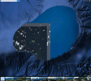
This is the island of Nihoa, northwest of Kauai, viewed in Google Maps. Hawaii on my mind. Anyway, it is a funny shot with mixed resolutions, bathymetry and optical imagery, and what looks to be a bordered image without its adjacent partner images. Web link: https://www.google.com/maps/@23.0606579,-161.8639537,39656m/data=!3m1!1e3
Wednesday
Mar112015

Mapsense talk at BIDS for your viewing pleasure

Here is Erez Cohen's excellent talk from the BIDS feed: http://bids.berkeley.edu/resources/videos/big-data-mapping-modern-tools-geographic-analysis-and-visualization

Title: Big Data Mapping: Modern Tools for Geographic Analysis and Visualization

Speaker: Erez Cohen, Co-Founder and CEO of Mapsense

We'll discuss how smart spatial indexes can be used for performant search and filtering for generating interactive and dynamic maps in the browser over massive datasets. We'll go over vector maps, quadtree indices, geographic simplification, density sampling, and real-time ingestion. We'll use example datasets featuring real-time maps of tweets, California condors, and crimes in San Francisco. 

The BIDS Data Science Lecture Series is co-hosted by BIDS and the Data, Science, and Inference Seminar. 

About the Speaker

Erez is co-founder and CEO at Mapsense, which is builds software for the analysis and visualization of massive spatial datasets. Previously Erez was an engineer at Palantir Technologies, where he worked with credit derivatives and mortgage portfolio datasets. Erez holds a BS/MS from UC Berkeley's Industrial Engineer and Operations Research Department. He was a PhD candidate in the same department at Columbia University.

Tuesday
Jan272015

100 Years of National Geographic Maps: The Art and Science of Where

Great retrospective on 100 years of National Geographic map making. 

100 Years of National Geographic Maps: The Art and Science of Where

Since 1915, National Geographic cartographers have charted earth, seas, and skies in maps capable of evoking dreams.

This beaut on the right is from 1968 of the ocean floor.  The article says: " Based on the work of geophysicists Bruce Heezen and Marie Tharp, this 1968 map of the ocean floor helped bring the concept of plate tectonics to a wide audience. Tharp began plotting the depths in 1950 from soundings taken by ships in the Atlantic, but, as a woman, wasn't allowed on the ships herself. In 1978 she was awarded the Society's Hubbard Medal for her pioneering research." 

Friday
Dec192014

The mapping process: musings at the end of 2014

Here are some evocative words about mapping from an unlikely source: in her astounding and engrossing book Wolf Hall, Hilary Mantel has Thomas Cromwell say:

But the trouble is, maps are always last year's. England is always remaking herself, her cliffs eroding, her sandbanks drifting, springs bubbling up in dead ground. They regroup themselves while we sleep, the landscapes through which we move..."

Lovely stuff! and a great holiday read (or re-read, or re-listen). It reminds us that mapping is a continual effort, a continuous process. All that we map changes: crops are harvested and fields are replanted, cities evolve, forests burn and re-grow, and people move across the face of the earth leaving traces. Our task is to capture in virtual space the key functional elements of space and time - through maps, through spectral reflectance and lidar, through text and discussions - so that we can find answers to to the key questions facing society today.

Excerpt From: Mantel, Hilary. Wolf Hall. Henry Holt and Company, 2009. iBooks.

Monday
Oct272014

Workshop on Oct 19: Planet Mapping: The Science of 3D Maps

swissnex San Francisco
730 Montgomery St., San Francisco, 94111
- See more at: http://www.swissnexsanfrancisco.org/event/planetmapping/#sthash.G5iIInIJ.dpuf
swissnex San Francisco
730 Montgomery St., San Francisco, 94111
- See more at: http://www.swissnexsanfrancisco.org/event/planetmapping/#sthash.G5iIInIJ.dpuf

Planet Mapping: The Science of 3D Maps. Find out what tools and techniques are enabling today’s modern cartographers to render 3D maps.

Location: swissnex San Francisco
730 Montgomery St., San Francisco, 94111

Our world is constantly being captured through GPS, cameras, satellites, and scanners and rendered by algorithms into navigable maps of Planet Earth. But how are 3D maps really made? How is the data collected?
Hear from some of the hottest startups in the field about the science and technology behind 3D map making—from data collection, to processing, to display—and discover how you can make your own 3D maps.
During the event, enjoy the visual stimulation of the PLACEMAKERS exhibit on view at swissnex San Francisco.

Program:

  • 6:30 pm doors open
  • 7:00 pm intro
  • 7:10 pm talks + Q&A
  • 8:45 pm networking reception

See more at: http://www.swissnexsanfrancisco.org/event/planetmapping/#sthash.G5iIInIJ.dpuf

Our world is constantly being captured through GPS, cameras, satellites, and scanners and rendered by algorithms into navigable maps of Planet Earth. But how are 3D maps really made? How is the data collected?

Hear from some of the hottest startups in the field about the science and technology behind 3D map making—from data collection, to processing, to display—and discover how you can make your own 3D maps.

During the event, enjoy the visual stimulation of the PLACEMAKERS exhibit on view at swissnex San Francisco.

Program

6:30 pm doors open
7:00 pm intro
7:10 pm talks + Q&A
8:45 pm networking reception

- See more at: http://www.swissnexsanfrancisco.org/event/planetmapping/#sthash.G5iIInIJ.dpuf
Wednesday
Oct222014

Check out the ZevRoss blog: Know Your Data

Technical Tidbits From Spatial Analysis & Data Science. This nice blog highlights many technical aspects of web mapping: Leaflet, D3, R... lots of neat examples.

Tuesday
Nov052013

Some cool images showing the power of lidar and cartography

From Martin Isenburg, the brain behind LAStools.

Using LAStools, ArcGIS, and Photoshop, GRAFCAN has produced a LiDAR-derived digital suface model (DSM) that is seriously doped up: a synthetic map providing an intuitive understanding of the landscape. The product combines standard hillshading with a height and feature based color-coding that enables the viewer to "see" where trees are tall and to grasp height differences between buildings. The new product is available at a resolution of 2.5 meters/pixel via the GRAFCAN Web viewer and also as a WMS service. More info and pics here: http://rapidlasso.com/2013/11/03/grafcan-launches-dsm-on-steroids/.

Comparison between bare earth DTM and DSM with cartography.


Check out the greenhouses, which ppear as “low planar vegetatation”. They are made out of coarse maze fabric (instead of glass) that lets the laser through and does not deflect it (like glass would).

Errors occurred while processing template[pageRendered/journal.st]:
StringTemplate Error: Can't parse chunk: {settingHomePageKBArticle}" target="_blank">Learn how.</a></li>
<li>If you have already selected a front page, make sure it is enabled. Click on the Cubes icon (top right) and then click the "enable page" button.</li>
</ol>
</div>

: expecting '"', found '<EOF>'
StringTemplate Error: problem parsing template 'pageRendered/noDefaultModule': null