blog authors
past blog entries

Welcome to the Kellylab blog

geospatial matters

Please read the UC Berkeley Computer Use Policy. Only members can post comments on this blog.

Entries in remote sensing (167)

Wednesday
Mar122014

Important proposed legislation limiting UAVs: consider reading this and commenting

AB1327 is a bill that could potentially impact the work that we do in regards to remote sensing and aerial imagery collection, etc… in the near future. See the link below for more detail. The office of the California CIO, Scott Gregory, is in the process of providing the Legislature a summary analysis of the bill. In our analysis we want to highlight civilian use (non-public safety governmental) cases for UAV technology as a rebuttal to some of the limiting language in the bill.

The bill would generally prohibit public agencies from using unmanned aircraft systems, or contracting for the use of unmanned aircraft systems, as defined, with certain exceptions applicable to law enforcement agencies and in certain other cases. The bill would require reasonable public notice to be provided by public agencies intending to deploy unmanned aircraft systems, as specified. The bill would require images, footage, or data obtained through the use of an unmanned aircraft system under these provisions to be permanently destroyed within 6 months, except as specified.

http://leginfo.legislature.ca.gov/faces/billNavClient.xhtml?bill_id=201320140AB1327
 
If this bill will affect your organization’s future data collection needs, please provide them a brief summary to be incorporated into the analysis.

Here is what I have sent to Scott Gregory:
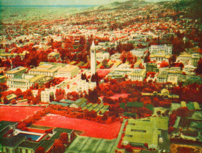
Maggi Kelly

Department of Environmental Sciences, Policy and Management

UC Berkeley

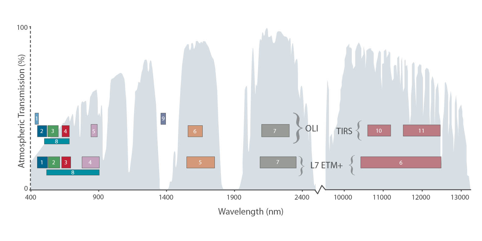
The use of civilian accessed UAV technology is commonly used for research purposes to aquire imagery at critical times over inaccessible field sites such as wetlands and forests, or over agricultural fields throught the growing season. This remote data acquisition using UAVs has several advantages: 1) it limits damage of the site, 2) it allows for mutliple returns in a cost-effective way, and 3) it allows for important very high resolution imagery to be collected. Here is a paper where we perfected techniques to find weeds in an agricultural field using UAV imagery. http://www.plosone.org/article/info%3Adoi%2F10.1371%2Fjournal.pone.0077151

Basically, they are looking for the organization name, use case and description of that use case. Please circulate to the user community within your respective organizations to solicit feedback. Please email or call if you have any questions. He would like to have these complied by 10am Friday (3/14/14).

Email: Scott Gregory Scott.Gregory@state.ca.gov

Thanks for your help.

Tuesday
Mar112014

Google Earth Demo at UCB

Thanks to Dave Thau, Karin Tuxen-Bettman, John Bailey, and Emily Henderson who came to visit the GIF and give a demo of the GEE toolbox. We went over the guts of GEE, Timelapse (very cool: make your own! Here is mine), the GEE GUI framework, and the GEE API. Very fun afternoon!

Friday
Feb142014

Happy Valentine's Day Landsat 8! 

It's meta-gorgeous, and better than spy vs spy: Landsat 8 catches a glimpse of its older, retired uncle Landsat 5. From NASA:

Feb 14, 2014 • Eight months ago, on June 5, 2013, the U.S. Geological Survey decommissioned the venerable Landsat 5 satellite. That day, the USGS Landsat Flight Operations Team transmitted the last command to Landsat 5, effectively terminating the mission and leaving it in a disposal orbit.

This week, Landsat 8 overflew the defunct Landsat 5, and thanks to some clever work by Mike Gartley, a Research Scientist with the Digital Imaging and Remote Sensing group at Rochester Institute of Technology (RIT)—a group that has long participated in Landsat calibration and validation—Landsat 5 was seen in an image taken by Landsat 8.

In these images, the satellite is seen as a streak of pixels (dark or light depending on the spectral band). There is one image from each of Landsat 8′s OLI bands, except for Band 7, or SWIR-2, where she blended into the clouds and was impossible to distinguish. In these images Landsat 5 is much closer to Landsat 8 than she is to the Earth. More here.

Friday
Feb072014

Musings about Robert N. Colwell

I am working on a retrospective of remote sensing of forests in California for the centennial. I am trying to highlight some of the pioneering work done by remote sensors that focused on Californian forests from the 1960s through the use of lidar today.

Oblique aerial view of Berkeley Campus of University of California taken with Camouflage Detection film. Robert N. Colwell

Of course with this topic you must begin with Robert N. Colwell. Dr. Colwell was an internationally renowned remote sensing scientist; he was former associate director of the Space Sciences Laboratory at the UC Berkeley, and he was the instructor of remote sensing in our own Mulford Hall from 1947 until his retirement in 1983. He was NASA co-investigator for Apollo IX, and his research in the 1960s on reflectance and multispectral reconnaissance were the primary basis for selecting the type of sensors and the spectral bands implemented in Landsat. Neat guy, and we all benefit from his intellectual legacy.

Anyway, for this paper, I am going through some of his work as he transitioned from aerial photography to digital imaging, and I came across this picture. Mulford is just off the scene in the upper left corner, and Hearst Gym pool is visible in lower part. In his caption he says:

"Oblique aerial view of Berkeley Campus of University of California taken with Camouflage Detection film." (That is what they used to call color infrared.) "Such photography is superior to any other for certain photo interpretation purposes as indicated by some of the preceding examples. Note in this photo how color values for each species of tree tend to remain uniform from foreground to background because of the superior haze penetration offered by this film. The relatively long wavelengths to which this infrared-sensitive film reacts are scattered but very little by atmospheric haze particles, thus accounting for the uniform color values and for excellent image sharpness." I dig this part: "The original color transparencies have the same color values as seen here and consequently make very attractive panels for lamp shades, although certain of their colors fade upon prolonged exposure to light."

The trend for using map products as kitchy home decorations PRE-DATES 1970! Take that hipsters!

Article source: Colwell, R.N. 1964. Aerial photography - A valuable sensor for the scientist. American Scientist, Vol. 52, No. 1 (MARCH 1964), pp. 16-49

Some more about him here: http://senate.universityofcalifornia.edu/inmemoriam/robertcolwell.htm

Thursday
Dec052013

Help to Validate Global Land Cover with GeoWiki and Cropland Capture

Courtesy of the International Institute for Applied Systems Analysis

This creative project from GeoWiki seeks to get croudsourced feedback on crop types from participants around the world. They say: 

By 2050 we will need to feed more than 2 billion additional people on the Earth. By playing Cropland Capture, you will help us to improve basic information about where cropland is located on the Earth's surface. Using this information, we will be better equipped at tackling problems of future food security and the effects of climate change on future food supply. Get involved and contribute to a good cause! Help us to identify cropland area!

Oh yeah, and there are prizes!

Each week (starting Nov. 15th) the top three players with the highest score at the end of each week will be added to our weekly winners list. After 25 weeks, three people will be drawn randomly from this list to become our overall winners. Prizes will include an Amazon Kindle, a brand new smartphone and a tablet.

Friday
Nov152013

Global forest change from Landsat and Google

The video describing the partnership and the product is available now.

A new high-resolution global map of forest loss and gain has been created with the help of Google Earth. The interactive online tool is publicly available and zooms in to a remarkably high level of local detail - a resolution of 30m. Snapshot of Russia here (green = forest, blue = gain, red = loss):

Russia has much forest activity

Results from time-series analysis of 654,178 Landsat images from 2000–2012 characterize forest extent and change. Between 2000 and 2012, according to this analysis, the Earth lost a combined "forest" the size of Mongolia. http://www.bbc.co.uk/news/science-environment-24934790

Here is the abstract from the accompanying paper in Science:

Quantification of global forest change has been lacking despite the recognized importance of forest ecosystem services. In this study, Earth observation satellite data were used to map global forest loss (2.3 million square kilometers) and gain (0.8 million square kilometers) from 2000 to 2012 at a spatial resolution of 30 meters. The tropics were the only climate domain to exhibit a trend, with forest loss increasing by 2101 square kilometers per year. Brazil’s well-documented reduction in deforestation was offset by increasing forest loss in Indonesia, Malaysia, Paraguay, Bolivia, Zambia, Angola, and elsewhere. Intensive forestry practiced within subtropical forests resulted in the highest rates of forest change globally. Boreal forest loss due largely to fire and forestry was second to that in the tropics in absolute and proportional terms. These results depict a globally consistent and locally relevant record of forest change.

Hansen, M.C.; Potapov, P.V.; Moore, R.; Hancher, M.; Turubanova, S.A.; Tyukavina, A.; Thau, D.; Stehman, S.V.; Goetz, S.J.; Loveland, T.R.; Kommareddy, A.; Egorov, A.; Chini, L.; Justice, C.O.; Townshend, J.R.G. High-Resolution Global Maps of 21st-Century Forest Cover Change. Science 2013, 342, 850-853

Thursday
Nov142013

NASA shares satellite and climate data on Amazon’s cloud


NASA has announced a partnership with Amazon Web Services that the agency hopes will spark wider collaboration on climate research. In an effort that is in some ways parallel to Google's Earth Engine, NASA has uploaded terabytes of data to Amazon's public cloud and made it available to the anyone. 

Three data sets are already up at Amazon. The first is climate change forecast data for the continental United States from NASA Earth Exchange (NEX) climate simulations, scaled down to make them usable outside of a supercomputing environment. The other two are satellite data sets—one from from the US Geological Survey's Landsat, and the other a collection of Moderate Resolution Imaging Spectroradiometer (MODIS) data from NASA's Terra and Aqua Earth remote sensing satellites.

More Here

Wednesday
Oct232013

FUEGO — A concept for a fire detection satellite

A nice press release about our new paper on the concepts behind a fire detection satellite with perhaps the coolest acronym yet: FUEGO — Fire Urgency Estimator in Geosynchronous Orbit. From Bob Sanders.

Artist's conception of the FUEGO satellite

Current and planned wildfire detection systems are impressive but lack both sensitivity and rapid response times. A small telescope with modern detectors and significant computing capacity in geosynchronous orbit can detect small (12 m2) fires on the surface of the earth, cover most of the western United States (under conditions of moderately clear skies) every few minutes or so, and attain very good signal-to-noise ratio against Poisson fluctuations in a second. Hence, these favorable statistical significances have initiated a study of how such a satellite could operate and reject the large number of expected systematic false alarms from a number of sources. We suggest a number of algorithms that can help reduce false alarms, and show efficacy on a few. Early detection and response would be of true value in the United States and other nations, as wildland fires continue to severely stress resource managers, policy makers, and the public, particularly in the western US. Here, we propose the framework for a geosynchronous satellite with modern imaging detectors, software, and algorithms able to detect heat from early and small fires, and yield minute-scale detection times. Open Access Journal Link. Press Release. KPIX spot.

Tuesday
Oct222013

Post American fire imagery

Check out these images from after the American fire, from the WorldView 2 satelllite from our northern SNAMP site. The blue boundary is our SNAMP site.  This background imagery is a pan-sharpened WV2 image (0.5 meters, channels 7, 5, 3). The red color depicts alive vegetation (at least for the time being) and green-blue is post-fire NPV (non-photosynthetic veg).  Thanks to Carlos Ramirez for the images.

 The post-fire imagery shows the heterogeneity of this fire - some spots burned all the vegetation, some spots have standing trees remaining.

Tuesday
Aug202013

American fire burns into SNAMP sites

American fire perimeter (red) as of 8-20-13The American fire is burning into our SNAMP study areas as of yesterday. Here is a snapshot of our study site and the fire perimeter (red) as of today (8-19-13 perimeter in orange). SNAMP control (yellow) and treatment (purple) watersheds are shown.

All SNAMP field crews are safely evacuated, with almost all field work completed for the year.

From the Incident Report: "The American Fire burning in heavy fuels on extreme slopes about 10 air miles northeast of the community of Foresthill, California, and eight air miles south of Interstate 80 has grown to 14,765 acres. While the fire is predominantly SimTable animation of American fire spread - modeled thru 8-14 I am guessingburning on the Tahoe National Forest within the North Fork of the Middle Fork American River drainage, there is a potential, given changes in weather or fire behavior, for the fire to threaten areas near Foresthill.

Active fire behavior continues on the eastern and southern flanks of the fire. Overnight, crews continued to build hand and dozer line to contain the active fire while evaluating future containment options. Firefighters will mop up and patrol containment line along Deadwood Road and Foresthill Divide Road south to the dozer line. Indirect line construction and mop up will continue down Deadwood Ridge. On the east side near Antoine, Manila and Screwauger Canyons, American fire as of 8-20-13 from ESRI onlinedirect and indirect line construction will continue, with support of retardant drops.

Active fire behavior and roll out of burning material continue to be of concern, and will be closely monitored. Strong, erratic outflow winds and lightning may occur today, as the National Weather Service’s Red Flag Warning remains in effect until 11 p.m. Wednesday.

Active fire behavior in very steep, inaccessible terrain makes preparation of contingency lines critical. Indirect attack is the safest way to manage fire in areas of steep and difficult terrain."

In the images to the left, both from ESRI online, there are a number of thermal hotposts in SNAMP territory American fire as of 8-21-13 from ESRI online(the red dots outside of the fire boundary) that were detected as of 10:30am 8-20-13 (upper image). As of 8-21-13 the MODIS hotspots indicate possible fire movement along Foresthill Rd to the east, and into the SNAMP control study area.


  Some resources:

We will keep you posted.

For more on the SNAMP project see: http://snamp.cnr.berkeley.edu/

This was originally posted on http://kellylab.berkeley.edu/.