blog authors
past blog entries

Welcome to the Kellylab blog

geospatial matters

Please read the UC Berkeley Computer Use Policy. Only members can post comments on this blog.

Wednesday
Oct142015

GIS-related courses for Spring 2016

Hello World!

There are several GIS classes to chose from in the spring. So far we have: 

Lower division:

  • ESPM 72 Geographic Information Systems *Not sure who is teaching this yet*

Upper division:

  • Biging, G & Radke, J ESPM 177 GIS and Environmental Spatial Data Analysis
  • Chambers, J    GEOG 185    Earth System Remote Sensing   
  • O'Sullivan, D   GEOG 187 Geographic Information Analysis

Graduate:

  • Radke, J    LDARC 221    Quantitative Methods in Environmental Planning
  • Dronova, I LDARC 221 Applied Remote Sensing
  • Chambers, J GEOG 285 Topics in Earth System Remote Sensing
  • Wang, I   ESPM 290 Special Topics in Environmental Science: Spatial Ecology

Email me with others. 
Thanks!
Friday
Oct092015

rOpenSci- new R package to search biodiversity data

Awesome new (ish?) R package from the gang over at rOpenSci 

Tired of searching biodiversity occurance data through individual platforms? The "spocc" package comes to your rescue and allows for a streamlined workflow in the collection and mapping of species occurrence data from range of sites including: GBIF, iNaturalist, Ecoengine, AntWeb, eBird, and USGS's BISON.

There is a caveat however, since the sites use alot of the same repositories the authors of the package caution to check for dulicates. Regardless what a great way to simplify your workflow!

Find the package from CRAN: install.packages("spocc") and read more about it here!

Tuesday
Sep292015

RUCS Rural Urban Connections Strategy

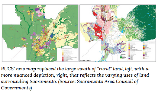
What started as a realtively small project in the Sacramento area to understand the rural agricultural sector has quickly transitioned into a project that hopes to have statewide impact. The premise of the project began with the ideas that planning maps and county data were unrepresentative of rural agricultural areas which in maps were shown as a single color, "green".  Using pesticide report data and remote sensing imagery the project was able to assemble a much more vibrant and representative map that now serves as the backbone of their models. 


This project called Rural-Urban Connections Strategy or RUCS for short made a huge impact on how the city council and politicans were veiwing the agricultural sector. Once the data was collected the folks at RUCS created an econometrics model to understanding the needs and costs of changing agricultural production across the area. See more about the model they employed here  and more information on their approach here

Using the methodology and tools below understanding the rural and urban connections of agricultural will become transferable and scalable so any local, regional, state or federal organization may adapt them.

1. SACOG created a CROP MAP that details agriculture production at the field level across more than 2 million acres of farmland. 

2. Building on the crop map, the ECONOMETRIC MODEL tests how cropping patterns could change under different conditions such as changes input costs.

3 The DIET/LAND NEEDS MODEL estimates how much land is needed to meet demand for locally grown food. 

4 The I-PLACE3S web-based land use modeling tool facilitates land use planning for agriculture and ruralcommunities. .

5 The INFRASTRUCTURE/FISCAL MODEL (IMPACS) provides local governments a means of evaluating the fiscal challenges and opportunities of providing infrastructure and services in their communities. 

Now the questions is how and where to scale RUCS up to a statewide assessment tool. More to come in furture conversations with the folks over at RUCS

Other helpful links from our discussion

Wednesday
Sep232015

Fall 2015 ANR GIS training schedule

Hello everyone in extension! Our IGIS workshop schedule for the fall is here. We have some great workshops scheduled for your geospatial pleasure.  These are coordinated with the workshops provided through the GIF

Fri, Sep 18 11am-4pm Hopland Research & Extension Center Web GIS and Mobile Data Collection
Wed, Oct 7 8am-12:30pm Sheraton Grand Hotel, Sacramento JSIC - Web GIS and Mobile Data Collection for ANR
Mon, Oct 19 11am-4pm UC Riverside Intro to GIS: Crop Agriculture Focus
Tues, Oct 20 11am-4pm

UC Riverside

Web GIS and Mobile Data Collection
Fri, Nov 20 10am-5pm UC ANR Building, Davis Intro to GIS: Forestry Emphasis
Fri, Dec 4 1pm-5pm UC Berkeley Web GIS and Mobile Data Collection
Thur, Jan 21 11am-4pm Lindcove Research and Extension Center Intro to GIS: Crop Agriculture Focus
Fri, Jan 22 10am-3pm Lindcove Research and Extension Center Web GIS and Mobile Data Collection
Wednesday
Sep232015

GIF+CartoDB workshop coming up! Oct 2

Free Workshop: Intro to CartoDB for Online Mapping

Andy Eschbacher, Map Scientist with CartoDB, will visit the GIF to teach this special hands-on workshop.CartoDB.com is a versatile cloud-powered spatial database, mapping, analysis and visualization engine that facilitates the process of building spatial applications for both web and mobile devices. The platform is currently used by major news organizations, research institutions, non-profits and geospatial application developers. This hands-on workshop will provide an introduction to managing, creating and analyzing spatial data and creating interactive map visualizations for the web, using the CartoDB platform.

If you are interested, you need to register here

Wednesday
Sep162015

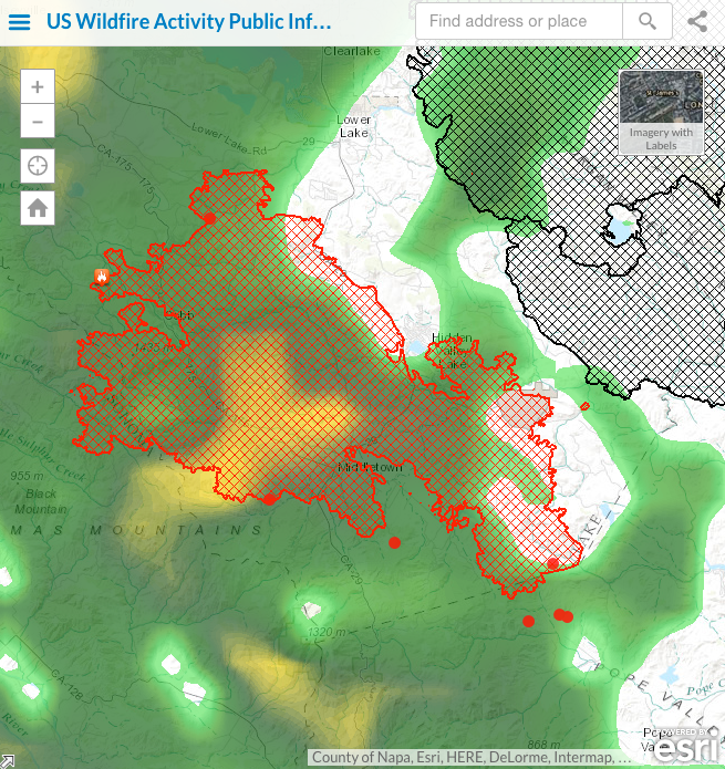
It is raining on the Valley Fire, thank goodness

Been addicted to the ESRI fire feed for its integration of numerous data sources. 

Here is the Valley Fire currently, and the rain that just hit us has moved north. 

For more: http://www.esri.com/services/disaster-response/wildlandfire/latest-news-map

Friday
Sep112015

Visualizing Vandalism in National Parks

A webmap featured in an article in the High Country News shows where vandalism has been reported most in protected areas across the West since 2013.  As the article associated with the map states, the areas most impacted are those closest to urban areas, particularly in the desert parks.  

Friday
Sep042015

Upcoming Events of Interest at Stanford

Wednesday
Sep022015

International Map Year

Did you know that it is International Map Year? 2015-2016.  

The International Map Year (IMY) is a worldwide celebration of maps and their unique role in our world. Supported by the United Nations, IMY provides opportunities to demonstrate, follow, and get involved in the art, science and technology of making and using maps and geographic information.

http://mapyear.org/about-international-map-year/

Think about ways in which maps can be integrated into your work!

Wednesday
Sep022015

False precision in the English Lidar release

Great commentary from Martin Isenburgon of LASTools fame on releasing data with false precision. This deals with the new open data release by the Environment Agency in England. So far LiDAR-derived DTM and DSM rasters have been released for 72% of the entire English territory at horizontal resolutions of 50 cm, 1 m, and 2 m. They can be downloaded here. The rasters are distributed as zipped archives of tiles in textual ASC format (*.asc). 

Martin gives us a cautionary tale on how not to release national data. It is not the ASC format that he has problems with, but the vertical precision. He says:

"The vertical resolution ranges from femtometers to attometers. This means that the ASCII numbers that specify the elevation for each grid cell are written down with 15 to 17 digits after the decimal point."

Example heights might be something like: 79.9499969482421875 or 80.23999786376953125. These data should be resolved to about the cm, not attometer, whatever that is. Crazy man!

Read the full post: http://rapidlasso.com/2015/09/02/england-releases-national-lidar-dem-with-insane-vertical-resolution/