publications by year

Selected Publications

My CV can be found here, my Google Scholar page is here and my Research Gate page is here. Links to directly downloadable papers are provided when possible - these are for individual use only; links to journals are also provided, but might not be available to users without campus library access. All papers are available upon request.

Entries in forests (29)

Tuesday
Jun282016

New paper: Mapping forest fuel treatments using Lidar

Su, Y, Q Guo, B M Collins, D L Fry, T Hu, and M Kelly. 2016.  Forest fuel treatment detection using multi-temporal airborne lidar data and high-resolution aerial imagery: a case study in the Sierra Nevada Mountains, California. International Journal of Remote Sensing 37(14): DOI: 10.1080/01431161.2016.1196842
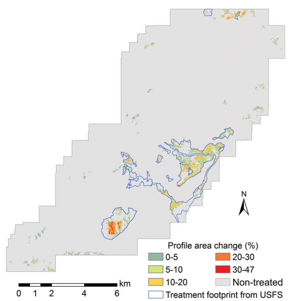
Forest change detection using lidarTreatments to reduce forest fuels are often performed in forests to enhance forest health, regulate stand density, and reduce the risk of wildfires. Although commonly employed, there are concerns that these forest fuel treatments (FTs) may have negative impacts on certain wildlife species. Often FTs are planned across large landscapes, but the actual treatment extents can differ from the planned extents due to operational constraints and protection of resources (e.g. perennial streams, cultural resources, wildlife habitats). Identifying the actual extent of the treated areas is of primary importance to understand the environmental influence of FTs. Light detection and ranging (lidar) is a powerful remote-sensing tool that can provide accurate measurements of forest structures and has great potential for monitoring forest changes. This study used the canopy height model (CHM) and canopy cover (CC) products derived from multi-temporal airborne laser scanning (ALS) data to monitor forest changes following the implementation of landscape-scale FT projects.

Click to read more ...

Thursday
Feb042016

New paper: mapping vegetation with lidar and aerial imagery

Su, Y, Q Guo, D L Fry, B M Collins, M Kelly, J P Flanagan & J J Battles. 2016. A Vegetation Mapping Strategy for Conifer Forests by Combining Airborne Lidar Data and Aerial Imagery. Canadian Journal of Remote Sensing 42:1–15 DOI: 10.1080/07038992.2016.1131114 

Accurate vegetation mapping is critical for natural resources management, ecological analysis, and hydrological modeling, among other tasks. Remotely sensed multispectral and hyperspectral imagery have proved to be valuable inputs to the vegetation mapping process, but they can provide limited vegetation structure characteristics, which are critical for differentiating vegetation communities in compositionally homogeneous forests. Light detection and ranging (lidar) can accurately measure the forest vertical and horizontal structures, and provide a great opportunity for solving this problem. This study introduces a strategy using both multispectral aerial imagery and lidar data to map vegetation composition and structure over large spatial scales.

Click to read more ...

Sunday
Dec202015

New paper: Challenges and opportunities in synthesizing historical geospatial data 

Eitzel, M V, Kelly, M, Dronova, I, Valachovic, Y, Quinn-Davidson, L, Solera, J, and de Valpine, P. 2016. Challenges and opportunities in synthesizing historical geospatial data using statistical models, Ecological Informatics 31: 100–111

We classified land cover types from 1940s historical aerial imagery using Object Based Image Analysis (OBIA) and compared these maps with data on recent cover. Few studies have used these kinds of maps to model drivers of cover change, partly due to two statistical challenges: 1) appropriately accounting for spatial autocorrelation and 2) appropriately modeling percent cover which is bounded between 0 and 100 and not normally distributed. We studied the change in woody cover at four sites in California’s North Coast using historical (1948) and recent (2009) high spatial resolution imagery.

Click to read more ...

Monday
Dec142015

Impacts of forest fuel treatments and wildfire on forests

Tempel, DJ, RJ Gutiérrez, JJ Battles, DL Fry, Y Su, Q Guo, MJ Reetz, SA Whitmore, GM Jones, BM Collins, SL Stephens, M Kelly, WJ Berigan, and MZ Peery. 2015. Modeling short- and long-term impacts of fuel treatments and wildfire on an old-forest species. Ecosphere 6(12) DOI:10.1890/ES15-00234.1

Fuels-reduction treatments are commonly implemented in the western U.S. to reduce the risk of high-severity fire, but they may have negative short-term impacts on species associated with older forests.   Therefore, we modeled the effects of a completed fuels-reduction project on fire behavior and California spotted owl (Strix occidentalis occidentalis) habitat and demography in the Sierra Nevada to assess the potential short- and long-term trade-offs.  We combined field-collected vegetation data and LiDAR data to develop detailed maps of forest structure needed to parameterize our fire and forest-growth models.  We simulated wildfires under extreme weather conditions (both with and without fuels treatments), then simulated forest growth 30 years into the future under four combinations of treatment and fire: treated with fire, untreated with fire, treated without fire, and untreated without fire.

Click to read more ...

Wednesday
Jun242015

Mapping discussions about forests and forest management

Lei, S. and M. Kelly. 2015. Evaluating adaptive collaborative management in Sierra Nevada forests by exploring public meeting dialogues using Self-Organizing Maps. Society and Natural Resources (28)8: 873-890

Heat map of discussion in SNAMP meetings: red conveys most consistently discussed topics; blue conveys least consistently discussedCollaborative adaptive management (CAM) is an appropriate management regime for social-ecological systems because it aims to reduce management uncertainties and fosters collaboration among diverse stakeholders. We evaluate the effectiveness of CAM in fostering collaboration among contentious multiparty environmental stakeholders based the Sierra Nevada Adaptive Management Project (SNAMP). Our evaluation focuses on facilitated public multiparty discussions (2005-2012). Self-organizing maps (SOM), an unsupervised machine-learning method, were used to process, organize, and visualize the public meeting notes.

Click to read more ...

Monday
May042015

Mapping forests with Lidar: a review highlighting the California perspective

Kelly, M. and S. Di Tommaso. 2015. Mapping forests with Lidar provides flexible, accurate data with many uses. California Agriculture 69(1): 14-20

The use of remote sensing for forest inventory, fire management, and wildlife habitat conservation planning has a decades-long and productive history, especially in California. The history of forest remote sensing in California follows a transition from aerial photography to digital remote sensing, in which Landsat plays a significant role, and today shows an increasing reliance on Lidar analysis. In California where forests are complex and difficult to accurately map, numerous remote sensing scientists have pioneered development of methodologies for forest mapping with Lidar.

Click to read more ...

Friday
Apr102015

Lidar + MODIS to upscale predictions of forest biomass

Li, L., Q. Guo, S. Tao, M. Kelly, and G. Xu. 2015. Lidar with multi-temporal MODIS provide a means to upscale predictions of forest biomass. ISPRS Journal of Photogrammetry and Remote Sensing. 102: 198–208

Forests play a key role in the global carbon cycle, and forest above ground biomass (AGB) is an important indictor to the carbon storage capacity and the potential carbon pool size of a forest ecosystem. Accurate estimation of forest AGB has become increasingly important for a wide range of end-users. Although satellite remote sensing provides abundant observations to monitor forest coverage, validation of coarse-resolution AGB derived from satellite observations is difficult because of the scale mismatch between the footprints of satellite observations and field measurements. In this study, we use airborne Lidar to bridge the scale gaps between satellite-based and field-based studies, and evaluate satellite-derived indices to estimate regional forest AGB.

Click to read more ...

Tuesday
Jan202015

20th-century shifts in forest structure in California - evidence from the VTM dataset

McIntyre, P. J., J. H. Thorne, C. R. Dolanc, A. L. Flint, L. E. Flint, M. Kelly and D. D. Ackerly. 2015. Twentieth-century shifts in forest structure in California: Denser forests, smaller trees, and increased dominance of oaks. Proceedings of the National Academy of Sciences 112(5): 1458-1463

change in climate water deficit (left) and change in large trees (right)We document changes in forest structure between historical (1930s) and contemporary (2000s) surveys of California vegetation through comparisons of tree abundance and size across the state and within several ecoregions. Across California, tree density in forested regions increased by 30% between the two time periods, whereas forest biomass in the same regions declined, as indicated by a 19% reduction in basal area. These changes reflect a demographic shift in forest structure: larger trees (>60 cm diameter at breast height) have declined, whereas smaller trees (<30 cm) have increased. Large tree declines were more severe in areas experiencing greater increases in climatic water deficit since the 1930s, based on a hydrologicmodel of water balance for historical climates through the 20th century.

Click to read more ...

Saturday
Nov292014

The role of private landowner in sustaining ecosystem services in California

Ferranto, S., L. Huntsinger and M. Kelly. 2014. Sustaining ecosystem services from private lands in California: the role of the landowner. Rangelands 36(5): 44-51

Forty percent, 13 million ha, of California’s forests and rangelands are privately owned. Deserts and forests are mostly in government ownership, while the state’s Mediterranean rangelands are largely in private hands: more than 80% of hardwood rangelands and annual grasslands are in private ownership. Landowner participation in sustaining ecosystem services means conservation initiatives need to build on landowner management objectives, practices, and goals.

Click to read more ...

Monday
Aug042014

Lidar-derived volume metrics for aboveground biomass estimation in conifer stands

individual trees in the lidar cloudTao, S., Li, L., Q. Guo, L. Li, B. Xue, M. Kelly, W. Li, G. Xu, and Y. Su. 2014. Airborne Lidar-derived volume metrics for aboveground biomass estimation: A comparative assessment for conifer stands. Agriculture and Forest Management 198–199: 24–3

Estimating aboveground biomass (AGB) is essential to quantify the carbon balance of terrestrial ecosystems, and becomes increasingly important under changing global climate. Volume metrics of individual trees, for example stem volume, have been proven to be strongly correlated to AGB. In this paper, we compared a range of airborne Lidar-derived volume metrics (i.e. stem volume, crown volume under convex hull, and crown volume under Canopy Height Model (CHM)) to estimate AGB. In addition, we evaluated the effect of horizontal crown overlap (which is often neglected in Lidar literature) on the accuracy of AGB estimation by using a hybrid method that combined marker-controlled watershed segmentation and point cloud segmentation algorithms.

Click to read more ...