New paper: Change detection in urban settings with pixel-based+obia methods
Xiao, P, X Zhang, D Wang, M Yuan, X Feng, M Kelly. 2016. Change detection of built-up land: A framework of combining pixel-based detection and object-based recognition. ISPRS Journal of Photogrammetry and Remote Sensing 119; 402–414
This study proposed a new framework that combines pixel-level change detection and object-level recognition to detect changes of built-up land from high-spatial resolution remote sensing images.
 obia, remote sensing
 Book chapter: OBIA history and futures
Blaschke, Thomas, Maggi Kelly, and Helena Merschdorf. Object-Based Image Analysis: Evolution, History, State of the Art, and Future Vision. Chapter 14 in Prasad Thenkabail (Editor) Remotely Sensed Data Characterization, Classification, and Accuracies. Taylor & Francis. 678 pp.
More fun with Thomas Blaschke delving into the history of obia and discussing possible new developments. An except of my bit on the Colwell-era antecedants of OBIA:
The conceptual foundations of OBIA are rooted in the 1960s with predigital aerial photography. e spatial information found in digital imagery that is harnessed in the object-based approach, for example, image texture, contextual information, pixel proximity, and geometric attributes of features, were discussed in the 1960s as possible components to yet possible automation of photo interpretation. In his seminal work on aerial photography and early remote sensing applications, Colwell (1965) describes the photo interpretation process as the act of examining photographic images for the purpose of identifying objects and judging their significance. He said that photo interpretation involves the observation of the size, shape, shadow, tone, texture, pattern, and location of the features, as well as the significance of the features, based largely on their interrelationships or association (Colwell 1965). His assessment of the potential for automation of an object recognition process depended on the capacities of a digital scanner and the ability of an algorithm to assess the differences, in photographic tone, between a "blob" and its surroundings (Colwell 1964, 1965). Colwell was an important advisor on the Landsat 1 mission, and his ideas on extraction of meaningful features transferred to his ambitions for the satellite missions (Colwell 1973).
historic, obia, remote sensing Geographic Object-Based Image Analysis – Towards a new paradigm
 A forest stand with sudden oak death: three common image spatial resolutions: 30 m, 4 m and 1 m.Blaschke, T., G.J. Hay, M. Kelly, S. Lang, P. Hofmann, E. Addink, R. Feitosa, F. Van Der Meer, H. Van Der Werff, F. Van Coillie, D. Tiede. 2014. Geographic Object-based Image Analysis: a new paradigm in Remote Sensing and Geographic Information Science. ISPRS International Journal of Photogrammetry and Remote Sensing 87(1), 180-191.
The amount of scientific literature on (Geographic) Object-based Image Analysis – GEOBIA has been and still is sharply increasing. These approaches to analysing imagery have antecedents in earlier research on image segmentation and use GIS-like spatial analysis within classification and feature extraction approaches. This article investigates these development and its implications and asks whether or not this is a new paradigm in remote sensing and Geographic Information Science (GIScience).
Mapping weeds with UAV and obia
 On-ground photographs and UAV images of the 1x1-m frames used in the ground-truth samplingPeña JM, Torres-Sánchez J, de Castro AI, Kelly M, López-Granados F. 2013. Weed Mapping in Early-Season Maize Fields Using Object-Based Analysis of Unmanned Aerial Vehicle (UAV) Images. PLoS ONE 8(10): e77151. doi:10.1371/journal.pone.0077151
The use of remote imagery captured by unmanned aerial vehicles (UAV) has tremendous potential for designing detailed site-specific weed control treatments in early post-emergence, which have not possible previously with conventional airborne or satellite images. A robust and entirely automatic object-based image analysis (OBIA) procedure was developed on a series of UAV images using a six-band multispectral camera (visible and near-infrared range) with the ultimate objective of generating a weed map in an experimental maize field in Spain. The OBIA procedure combines several contextual, hierarchical and object-based features and consists of three consecutive phases: 1) classification of crop rows by application of a dynamic and auto-adaptive classification approach, 2) discrimination of crops and weeds on the basis of their relative positions with reference to the crop rows, and 3) generation of a weed infestation map in a grid structure. The estimation of weed coverage from the image analysis yielded satisfactory results.
Delineating individual trees from lidar data
 One SNAMP forest plot viewed with lidar dataJakubowski, MK, L Wenkai, Q Guo, and M Kelly. 2013. Delineating individual trees from lidar data: a comparison of vector- and raster-based segmentation approaches. Remote Sensing 5, 4163-4186; doi:10.3390/rs5094163
This work concentrates on delineating individual trees from discrete lidar data in topographically-complex, mixed conifer forest across the California’s Sierra Nevada. We delineated individual trees using vector data and a 3D lidar point cloud segmentation algorithm, and using raster data with an object-based image analysis (OBIA) of a canopy height model (CHM). The two approaches are compared to each other and to ground reference data. We used high density (9 pulses/m2), discreet lidar data and WorldView-2 imagery to delineate individual trees, and to classify them by species or species types.
forests, last chance, lidar, obia, open access, remote sensing, snamp Finding trees in the lidar point cloud
 individual trees extracted from the lidar point cloudLi, W., Q. Guo, M. Jakubowski and M. Kelly. 2012. A new method for segmenting individual trees from the lidar point cloud. Photogrammetric Engineering and Remote Sensing 78(1): 75-84
In this study we develop a new algorithm to segment individual trees from the small footprint discrete return airborne lidar point cloud. The new algorithm adopts a top-to-bottom region growing approach that segments trees individually and sequentially from the tallest to the shortest. We experimentally applied the new algorithm to segment trees in a mixed coniferous forest in the Sierra Nevada Mountains in California, USA. Our results indicate that the proposed algorithm has good potential in segmenting individual trees in mixed conifer stands of similar structure using small footprint, discrete return lidar data.
forests, lidar, obia, remote sensing, snamp, sugar pine Mapping downed logs with lidar + obia
 downed logs in redBlanchard, S., M. Jakubowski, and M. Kelly. 2011. Object-based image analysis of downed logs in a disturbed forest landscape using lidar. Remote Sensing 3(11): 2420-2439.
Downed logs on the forest floor provide habitat for species, fuel for forest fires, and function as a key component of forest nutrient cycling and carbon storage. This study evaluates the utility of discrete, multiple return airborne lidar-derived data for image object segmentation and classification of downed logs in a disturbed forested landscape and the efficiency of rule-based object-based image analysis (OBIA) and classification algorithms.
forests, last chance, lidar, obia, open access, remote sensing, snamp Use of obia in public health - a review, and call for more
Kelly M., S. Blanchard. E. Kersten and K. Koy. 2011. Object-based analysis of imagery in support of public health: new avenues of research. Remote Sensing 3:2321-2345
The benefits of terrestrial remote sensing in the environmental sciences are clear across a range of applications, and increasingly remote sensing analyses are being integrated into public health research. This integration has largely been in two areas: first, through the inclusion of continuous remote sensing products such as normalized difference vegetation index (NDVI) or moisture indices to answer large-area questions associated with the epidemiology of vector-borne diseases or other health exposures; and second, through image classification to map discrete landscape patches that provide habitat to disease-vectors or that promote poor health. In this second arena, new improvements in object-based image analysis (or “OBIA”) can provide advantages for public health research. This paper provides a brief review of what has been done in the public health literature with continuous and discrete mapping, and then highlights the key concepts in OBIA that could be more of use to public health researchers interested in integrating remote sensing into their work.
health, obia, open access, remote sensing Urban influence on changes in linear forest edge structure
De Chant, T., A. H. Gallego, J. V. Saornil and M. Kelly. 2010. Urban influence on changes in linear forest edge structure. Landscape and Urban Planning 96: 12-18
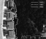 An example of changing edge sinuosity We studied how forest edges at two California coastal oak woodlands (Pacheco Valle and China Camp) in the San Francisco Bay Area in California changed in the decades following urbanization using remote sensing and object based image analysis.
Individual object change detection for hardwood forest disease monitoring
De Chant, T. and M. Kelly. 2009. Individual object change detection for monitoring the impact of a forest pathogen on a hardwood forest. Photogrammetric Engineering and Remote Sensing 75(8): 1005-1014
Using 4-band, 1 m spatial resolution aerial photography, we classified four annual images (2000 to 2003) with object-based image analysis and employed a GIS for our change detection technique to follow the fate of forest gaps caused by sudden oak death.
