publications by year

Selected Publications

My CV can be found here, my Google Scholar page is here and my Research Gate page is here. Links to directly downloadable papers are provided when possible - these are for individual use only; links to journals are also provided, but might not be available to users without campus library access. All papers are available upon request.

Entries in metrics (7)

Monday
Dec272010

Mapping changes in tidal wetland vegetation composition

Tuxen, K, L Schile, D Stralberg, S Siegel, T Parker, M Vasey, J Callaway, and M Kelly. 2011. Mapping changes in tidal wetland vegetation composition and pattern across a salinity gradient using high spatial resolution imagery. Wetland Ecology and Management 19:141-157

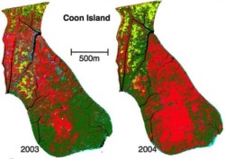
Coon Island vegetation over two years. We mapped vegetation at six tidal marshes (two natural, four restored) in the San Francisco Estuary, CA, USA, between 2003 and 2004 using detailed vegetation field surveys and high spatial-resolution color-infrared aerial photography. Vegetation classes were determined by performing hierarchical agglomerative clustering on the field data collected from each tidal marsh.

Click to read more ...

Friday
Nov122010

Pattern metrics for wetland restoration management

Kelly, M., K. Tuxen and D. Stralberg. 2011. Mapping changes to vegetation pattern in a restoring wetland: Finding pattern metrics that are consistent across spatial scale and time. Ecological Indicators 11: 263-273. We sought to identify pattern metrics that are consistent across spatial scale and time – and thus robust measures of vegetation and habitat configuration – for a restored tidal marsh in the San Francisco Bay, CA, USA.

Click to read more ...

Wednesday
May122010

Predicting bird abundance in tidal marshes

Predicted mean abundance for common yellowthroat at Browns Is. and Sherman Lake

Stralberg, D., M. Herzog, N. Nur, K. Tuxen, S. Siegel and M. Kelly. 2010. Predicting avian abundance within and across tidal marshes using fine-scale vegetation and geomorphic metrics. Wetlands 30: 475-487

We used a blend of fine-scale remote sensing products and field-based survey data via spatial predictive models to aid in monitoring restoring tidal marshes for bird habitat. We developed a suite of 1-m pixel-level spatial metrics describing patterns in marsh vegetation and geomorphology for six sites across a large salinity gradient, and used these to predict avian abundance.

Click to read more ...

Sunday
May092010

Urban influence on changes in linear forest edge structure

De Chant, T., A. H. Gallego, J. V. Saornil and M. Kelly. 2010. Urban influence on changes in linear forest edge structure. Landscape and Urban Planning 96: 12-18

An example of changing edge sinuosity We studied how forest edges at two California coastal oak woodlands (Pacheco Valle and China Camp) in the San Francisco Bay Area in California changed in the decades following urbanization using remote sensing and object based image analysis.

Click to read more ...

Saturday
Dec312005

Watershed-scale land use and salmon habitat

Opperman, et al. 2005. Canadian Journal of Fisheries and Aquatic Science. Relationships between land use or land cover and embeddedness, a measure of fine sediment in spawning gravels, were examined at multiple scales across 54 streams in the Russian River Basin, California. The results suggest that coarse-scale measures of watershed land use can explain a large proportion of the variability in embeddedness and that the explanatory power of this relationship increases with watershed size.

Click to read more ...

Sunday
Jul312005

Landscape metrics in freshwater research and management

Kearns et al. 2005. Landscape Ecology. A portion of the study area around San Jose, CAWe quantified landscape composition and configuration for subwatershed areas upstream of individual sampling sites, reducing the number of metrics based on: (1) sensitivity to changes in extent and (2) redundancy, as determined by a multivariate factor analysis.

Click to read more ...

Wednesday
Oct312001

Changes to the landscape pattern of coastal NC wetlands under the Clean Water Act

Kelly, 2001. Landscape Ecology. A collection of Section 404 permits from 1984 through 1992 was analyzed in conjunction with classified Landsat Thematic Mapper data from 1984 and 1992 in order to quantify changes to wetland habitat in the study area in coastal North Carolina.

Click to read more ...