Mapping changes in tidal wetland vegetation composition
Tuxen, K, L Schile, D Stralberg, S Siegel, T Parker, M Vasey, J Callaway, and M Kelly. 2011. Mapping changes in tidal wetland vegetation composition and pattern across a salinity gradient using high spatial resolution imagery. Wetland Ecology and Management 19:141-157.
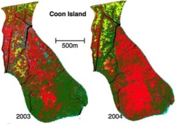 Coon Island vegetation over two years.We mapped vegetation at six tidal marshes (two natural, four restored) in the San Francisco Estuary, CA, USA, between 2003 and 2004 using detailed vegetation field surveys and high spatial-resolution color-infrared aerial photography. Vegetation classes were determined by performing hierarchical agglomerative clustering on the field data collected from each tidal marsh. The number of vegetation classes decreased with salinity, and increased with size and age. In general, landscape diversity, as measured by the Shannon’s diversity index, also decreased with salinity, with an exception for the most saline site, a newly restored marsh. Vegetation change between years is evident, but the differences across sites in composition and pattern were larger than change within sites over two growing seasons. Journal Link. Pdf download.
Keywords: Remote sensing . Color infrared aerial photography . San Francisco Bay
 metrics, pattern, remote sensing, wetlands