publications by year

Selected Publications

My CV can be found here, my Google Scholar page is here and my Research Gate page is here. Links to directly downloadable papers are provided when possible - these are for individual use only; links to journals are also provided, but might not be available to users without campus library access. All papers are available upon request.

Entries in karin tuxen (7)

Monday
Dec272010

Mapping changes in tidal wetland vegetation composition

Tuxen, K, L Schile, D Stralberg, S Siegel, T Parker, M Vasey, J Callaway, and M Kelly. 2011. Mapping changes in tidal wetland vegetation composition and pattern across a salinity gradient using high spatial resolution imagery. Wetland Ecology and Management 19:141-157
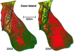
Coon Island vegetation over two years. We mapped vegetation at six tidal marshes (two natural, four restored) in the San Francisco Estuary, CA, USA, between 2003 and 2004 using detailed vegetation field surveys and high spatial-resolution color-infrared aerial photography. Vegetation classes were determined by performing hierarchical agglomerative clustering on the field data collected from each tidal marsh.

Click to read more ...

Friday
Nov122010

Pattern metrics for wetland restoration management

Kelly, M., K. Tuxen and D. Stralberg. 2011. Mapping changes to vegetation pattern in a restoring wetland: Finding pattern metrics that are consistent across spatial scale and time. Ecological Indicators 11: 263-273. We sought to identify pattern metrics that are consistent across spatial scale and time – and thus robust measures of vegetation and habitat configuration – for a restored tidal marsh in the San Francisco Bay, CA, USA.

Click to read more ...

Wednesday
May122010

Predicting bird abundance in tidal marshes

Predicted mean abundance for common yellowthroat at Browns Is. and Sherman Lake

Stralberg, D., M. Herzog, N. Nur, K. Tuxen, S. Siegel and M. Kelly. 2010. Predicting avian abundance within and across tidal marshes using fine-scale vegetation and geomorphic metrics. Wetlands 30: 475-487

We used a blend of fine-scale remote sensing products and field-based survey data via spatial predictive models to aid in monitoring restoring tidal marshes for bird habitat. We developed a suite of 1-m pixel-level spatial metrics describing patterns in marsh vegetation and geomorphology for six sites across a large salinity gradient, and used these to predict avian abundance.

Click to read more ...

Wednesday
Jul302008

Mapping vegetation colonization in a restoring tidal marsh

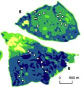
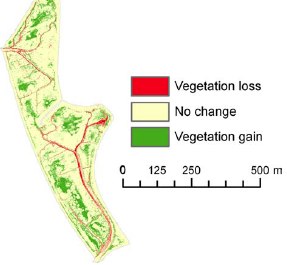
Tuxen, et al. 2008. Restoration Ecology. Vegetation colonization in a restored marshWe used NDVI to document vegetation colonization in a restoring salt marsh. This method was effective at detecting change in vegetation over time in a variable tidal marsh environment using imagery that had inconsistent specifications and quality across years.

Click to read more ...

Friday
Dec312004

Geospatial informatics for management of Sudden Oak Death

Kelly, et al. 2004. Photogrammetric Engineering and Remote Sensing. For a geographer viewing the early days of the SOD epidemic, there were several intriguing spatial aspects on which a monitoring system could be built, including: 1) disease impact was clearly visible at multiple spatial scales, making remote sensing useful in the monitoring process; 2) disease spread and consequent mortality were patchy at landscape scales, making spatial analysis useful; 3) the disease appeared to be spatially regulated, making accurate spatial data collected using GPS and maintained and mapped using GIS critical; and 4) public awareness and concern about the disease were high, and public participation was needed in the monitoring/tracking process, making webGIS and cartography immediately useful tools for information distribution and management assistance.

Click to read more ...

Wednesday
Dec312003

webGIS as a tool for sustainable natural resource management

Kearns et al. 2003. Frontiers in Ecology and the Environment. Whether tracking invasive species, assessing water quality, or monitoring the spread of disease, comprehensive data collection is a key component of sustainable natural resource management. Increasingly, fostering community-based monitoring is seen as a valuable way to augment data gathering and enhance public involvement in environmental management.

Click to read more ...

Sunday
Nov302003

WebGIS for monitoring sudden oak death in California

Kelly and Tuxen. 2003. Computers, Environment and Urban Systems. This paper describes in detail how the oakmapper webGIS application was developed, implemented, and used, and discusses some of the common application problems associated with the project, as well as the larger societal issues of Internet access, quality control, and privacy.

Click to read more ...