publications by year

Selected Publications

My CV can be found here, my Google Scholar page is here and my Research Gate page is here. Links to directly downloadable papers are provided when possible - these are for individual use only; links to journals are also provided, but might not be available to users without campus library access. All papers are available upon request.

Entries in lidar (14)

Tuesday
Jun282016

New paper: Mapping forest fuel treatments using Lidar

Su, Y, Q Guo, B M Collins, D L Fry, T Hu, and M Kelly. 2016.  Forest fuel treatment detection using multi-temporal airborne lidar data and high-resolution aerial imagery: a case study in the Sierra Nevada Mountains, California. International Journal of Remote Sensing 37(14): DOI: 10.1080/01431161.2016.1196842
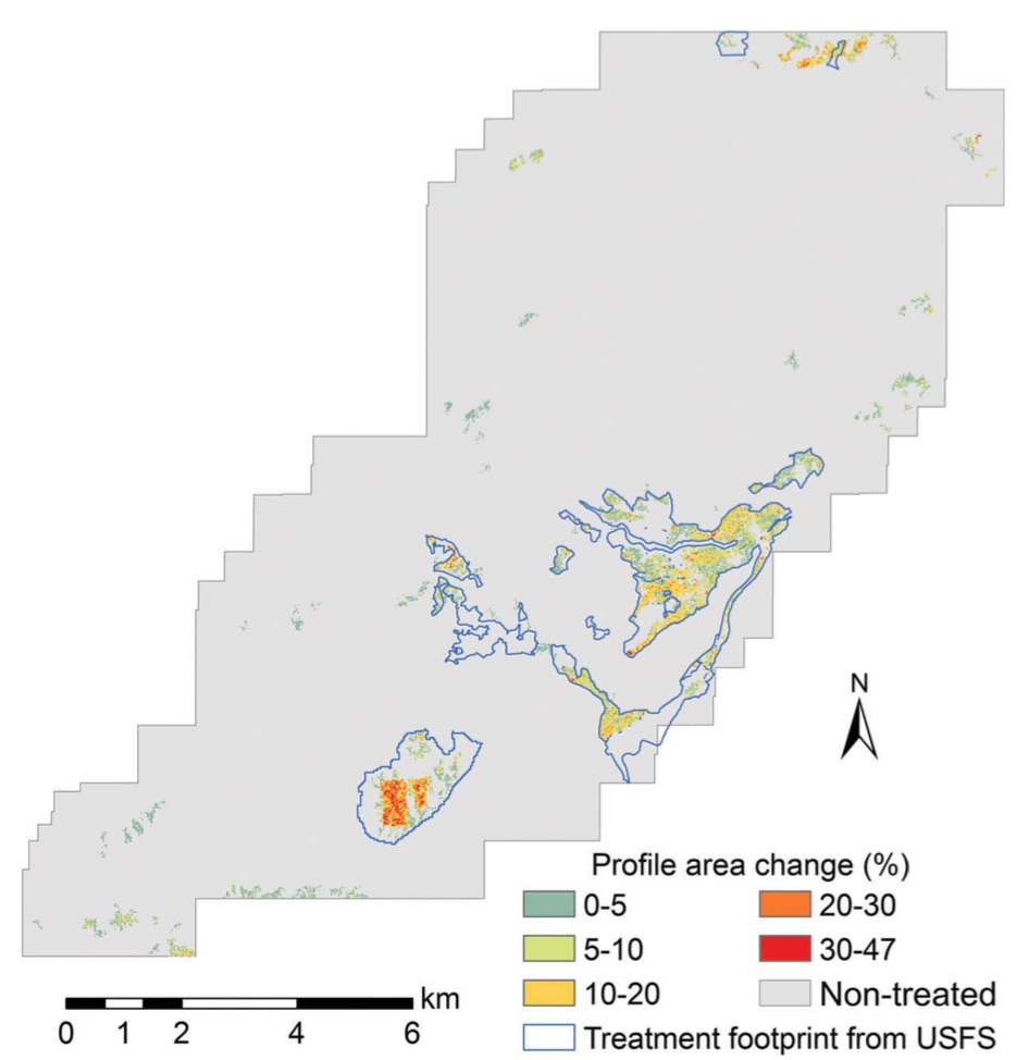
Forest change detection using lidarTreatments to reduce forest fuels are often performed in forests to enhance forest health, regulate stand density, and reduce the risk of wildfires. Although commonly employed, there are concerns that these forest fuel treatments (FTs) may have negative impacts on certain wildlife species. Often FTs are planned across large landscapes, but the actual treatment extents can differ from the planned extents due to operational constraints and protection of resources (e.g. perennial streams, cultural resources, wildlife habitats). Identifying the actual extent of the treated areas is of primary importance to understand the environmental influence of FTs. Light detection and ranging (lidar) is a powerful remote-sensing tool that can provide accurate measurements of forest structures and has great potential for monitoring forest changes. This study used the canopy height model (CHM) and canopy cover (CC) products derived from multi-temporal airborne laser scanning (ALS) data to monitor forest changes following the implementation of landscape-scale FT projects.

Click to read more ...

Monday
May042015

Mapping forests with Lidar: a review highlighting the California perspective

Kelly, M. and S. Di Tommaso. 2015. Mapping forests with Lidar provides flexible, accurate data with many uses. California Agriculture 69(1): 14-20

The use of remote sensing for forest inventory, fire management, and wildlife habitat conservation planning has a decades-long and productive history, especially in California. The history of forest remote sensing in California follows a transition from aerial photography to digital remote sensing, in which Landsat plays a significant role, and today shows an increasing reliance on Lidar analysis. In California where forests are complex and difficult to accurately map, numerous remote sensing scientists have pioneered development of methodologies for forest mapping with Lidar.

Click to read more ...

Friday
Apr102015

Lidar + MODIS to upscale predictions of forest biomass

Li, L., Q. Guo, S. Tao, M. Kelly, and G. Xu. 2015. Lidar with multi-temporal MODIS provide a means to upscale predictions of forest biomass. ISPRS Journal of Photogrammetry and Remote Sensing. 102: 198–208

Forests play a key role in the global carbon cycle, and forest above ground biomass (AGB) is an important indictor to the carbon storage capacity and the potential carbon pool size of a forest ecosystem. Accurate estimation of forest AGB has become increasingly important for a wide range of end-users. Although satellite remote sensing provides abundant observations to monitor forest coverage, validation of coarse-resolution AGB derived from satellite observations is difficult because of the scale mismatch between the footprints of satellite observations and field measurements. In this study, we use airborne Lidar to bridge the scale gaps between satellite-based and field-based studies, and evaluate satellite-derived indices to estimate regional forest AGB.

Click to read more ...

Monday
Aug042014

Lidar-derived volume metrics for aboveground biomass estimation in conifer stands

individual trees in the lidar cloudTao, S., Li, L., Q. Guo, L. Li, B. Xue, M. Kelly, W. Li, G. Xu, and Y. Su. 2014. Airborne Lidar-derived volume metrics for aboveground biomass estimation: A comparative assessment for conifer stands. Agriculture and Forest Management 198–199: 24–3

Estimating aboveground biomass (AGB) is essential to quantify the carbon balance of terrestrial ecosystems, and becomes increasingly important under changing global climate. Volume metrics of individual trees, for example stem volume, have been proven to be strongly correlated to AGB. In this paper, we compared a range of airborne Lidar-derived volume metrics (i.e. stem volume, crown volume under convex hull, and crown volume under Canopy Height Model (CHM)) to estimate AGB. In addition, we evaluated the effect of horizontal crown overlap (which is often neglected in Lidar literature) on the accuracy of AGB estimation by using a hybrid method that combined marker-controlled watershed segmentation and point cloud segmentation algorithms.

Click to read more ...

Monday
Jun232014

Quantifying ladder fuels with lidar

Kramer, H. A., B. Collins, M. Kelly, S. Stephens. Quantifying ladder fuels in forests: a new approach using LiDAR. Forests 5:1432-1453

We investigated the relationship between LiDAR and ladder fuels in the northern Sierra Nevada, California USA. LiDAR has only been used to address this question peripherally and in only a few instances. After establishing that landscape fuel treatments reduced canopy and ladder fuels at our site, we tested which LiDAR-derived metrics best differentiated treated from untreated areas. The percent cover between 2 and 4 m had the most explanatory power to distinguish treated from untreated pixels across a range of spatial scales.

Click to read more ...

Thursday
Aug222013

Delineating individual trees from lidar data

One SNAMP forest plot viewed with lidar dataJakubowski, MK, L Wenkai, Q Guo, and M Kelly. 2013. Delineating individual trees from lidar data: a comparison of vector- and raster-based segmentation approaches. Remote Sensing 5, 4163-4186; doi:10.3390/rs5094163

This work concentrates on delineating individual trees from discrete lidar data in topographically-complex, mixed conifer forest across the California’s Sierra Nevada. We delineated individual trees using vector data and a 3D lidar point cloud segmentation algorithm, and using raster data with an object-based image analysis (OBIA) of a canopy height model (CHM). The two approaches are compared to each other and to ground reference data. We used high density (9 pulses/m2), discreet lidar data and WorldView-2 imagery to delineate individual trees, and to classify them by species or species types.

Click to read more ...

Thursday
Jan172013

Capturing forest fuel characteristics with lidar

Jakubowski, M. K., Q. Guo, B. Collins, S. Stephens, and M. Kelly. 2013. Predicting surface fuel models and fuel metrics using lidar and CIR imagery in a dense, mountainous forest. Photogrammetric Engineering and Remote Sensing 79(1):37-49

We compared the ability of several classification and regression algorithms to predict forest stand structure metrics and standard surface fuel models. Our study area spans across a dense, topographically complex Sierra Nevada mixed-conifer forest. We used clustering, regression trees, and support vector machine algorithms to analyze high density (average 9 pulses/m2), discrete return, smallfootprint lidar data, along with multispectral imagery. Stand structure metric predictions generally decreased with increased canopy penetration. While the general fuel types were predicted accurately, specific surface fuel model predictions were poor using all algorithms. These fuel components are critical inputs for wildfire behavior modeling, which ultimately support forest management decisions.

Click to read more ...

Thursday
Dec132012

Low density lidar provides valuable plot-level forest data

Jakubowski, M., Q. Guo, and M. Kelly. 2013. Tradeoffs between lidar pulse density and forest measurement accuracy. Remote Sensing of Environment. 130: 245–253.

lidar density examples: 9 - 0.01 pl/m2

Discrete lidar is increasingly used to analyze forest structure. Technological improvements in lidar sensors have led to the acquisition of increasingly high pulse densities, possibly reflecting the assumption that higher densities will yield better results. In this study, we systematically investigated the relationship between pulse density and the ability to predict several commonly used forest measures and metrics at the plot scale. The accuracy of predicted metrics was largely invariant to changes in pulse density at moderate to high densities. In particular, correlations between metrics such as tree height, diameter at breast height, shrub height and total basal area were relatively unaffected until pulse densities dropped below 1 pulse/m2. Metrics pertaining to coverage, such as canopy cover, tree density and shrub cover were more sensitive to changes in pulse density, although in some cases high prediction accuracy was still possible at lower densities.

Click to read more ...

Sunday
Aug122012

Allometric equation choice impacts lidar-based forest biomass estimates

lidar point cloud from the snamp projectZhao, F., Q. Guo and M. Kelly. 2012. Allometric equation choice impacts lidar-based forest biomass estimates: A case study from the Sierra National Forest, CA. Agricultural and Forest Meteorology 165: 64–72

Plot-level estimates of biomass were derived from field data and two different allometric equations. Estimates differed between allometric equations, especially in plots with high biomass. Selection of allometric equations can influence the capacity of lidar data to estimate biomass. The best fit between field data and lidar data were found using a regional allometric equation and a combination of lidar metrics and individual tree data.

Keywords: Lidar . Allometric equation . Biomass .  Sierra Nevada .  Forest

Journal link. Pdf download.

Saturday
Jul072012

Mapping fisher denning trees with lidar

Zhao, F., R.A. Sweitzer, Q. Guo, and M. Kelly. 2012. Characterizing habitats associated with fisher den structures in the Southern Sierra Nevada, California using discrete return lidar. Forest Ecology and Management 280: 112–119

This study explored the ability of lidar-derived metrics to capture topography and forest structure surrounding denning trees used by the Pacific fisher (Martes pennanti) as a case study to illustrate the utility of lidar remote sensing in studying mammal-habitat associations. We used Classification and Regression Trees (CART) to statistically compare the slope and lidar-derived forest height and structure metrics in the circular area (with radius of 10–50 m) surrounding denning trees and randomly selected non-denning trees. We accessed our model accuracy using resubstitution and cross-validation methods. Our results show that there is a strong association between fisher denning activity and its surrounding forested environment across scales, with high classification accuracy (overall accuracies above 80% and cross-validation accuracies above 70%) at 20, 30 and 50 m ranges. The best classification accuracies were found at 20 m (optimal resubstitution accuracy 86.2% and cross-validation accuracy 78%). Tree height and slope were important variables in classifying the area immediately surrounding denning trees; at scales larger than 20 m, forest structure and complexity became more important. Pdf download. Journal link.