publications by year

Selected Publications

My CV can be found here, my Google Scholar page is here and my Research Gate page is here. Links to directly downloadable papers are provided when possible - these are for individual use only; links to journals are also provided, but might not be available to users without campus library access. All papers are available upon request.

Entries in sod (19)

Thursday
Apr282011

Oakmapper: citizen science, webGIS, and volunteered information

Connors, J., S. Lei and M. Kelly. 2012. Citizen science in the age of neogeography: utilizing volunteered geographic information for environmental monitoring. Annals of the Association of American Geographers 102(6): 1267-1289

The interface between neogeography and citizen science has great potential for environmental monitoring, but this nexus has been explored less often than each subject individually. In this article we review the emerging role of volunteered geographic information in citizen science, and present a case study of an integrated toolset that engages multiple types of users (from targeted citizen-based observation networks, expert-driven focused monitoring, and opportunistic crowdsourcing efforts) in monitoring a forest disease in the western U.S.

Click to read more ...

Monday
May102010

Survival of oaks and tanoaks after 8 years of SOD monitoring

McPherson, B. M., D. L. Wood, S. Mori, M. Kelly, A. J. Storer, P. Svihra, and R. B. Standiford. 2010. Survival of oaks and tanoaks after eight years of sudden oak death monitoring in coastal California. Forest Ecology and Management 259: 2248-2255

We report on the survival of trees (coast live oaks, black oaks, and tanoaks) in long-term SOD monitoring plots in Marin County.

Click to read more ...

Thursday
Dec312009

Individual object change detection for hardwood forest disease monitoring

De Chant, T. and M. Kelly. 2009. Individual object change detection for monitoring the impact of a forest pathogen on a hardwood forest. Photogrammetric Engineering and Remote Sensing 75(8): 1005-1014

Using 4-band, 1 m spatial resolution aerial photography, we classified four annual images (2000 to 2003) with object-based image analysis and employed a GIS for our change detection technique to follow the fate of forest gaps caused by sudden oak death.

Click to read more ...

Wednesday
Dec312008

Spatial pattern dynamics of oak mortality & disease symptoms

Kelly et al. 2008. Journal of Forest Research. We used two-dimensional spatial analysis tools with data gathered in point-centered-quarter format in 2001 and 2004 to quantify 1) population density of the disease through time; 2) spatial pattern of tree mortality across scales through time; and 3) spatial co-occurrence of disease symptoms with crown mortality through time.

Click to read more ...

Wednesday
Jul302008

Oak health and leaf spectral response

Pu et al. 2008. GeoCarto International. The spectroscopic determination of two health levels of the coast live oak leaves was conducted with three sets of spectra. Based on our experimental results and previous work, existing remote sensing techniques, including airborne or satellite remote sensing and multispectral or hyperspectral remote sensing, may be insufficient for monitoring and mapping disease-induced moisture stress in trees that have recently been infected.

Click to read more ...

Saturday
May312008

Mapping SOD related stress with CASI

Pu, R., M. Kelly, G. L. Anderson, and P. Gong. 2008. Using CASI hyperspectral imagery to detect mortality and vegetation stress associated with a new hardwood forest disease. Photogrammetric Engineering & Remote Sensing 74(1): 65‐75

A CASI dataset was used for detecting mortality and vegetation stress associated with a new forest disease. Pdf download.

Wednesday
Oct312007

Spatial‐temporal tree mortality patterns associated with SOD

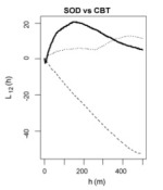
Liu, et al. 2007. Forest Ecology and Management. Inhomogeneous cross-K-functions of SOD and California bay trees: the peak in the dark line indicates co-clusteringWe analyzed the spatial–temporal patterns of overstory oak tree mortality in China Camp State Park, CA over 4 years using the point patterns mapped from high spatial resolution remotely sensed imagery. Both univariate and multivariate spatial point pattern analyses were performed (inhomogeneous K-functions and Neyman–Scott point processes) to characterize the spatial dependence among dead oak trees in each year, and between dead oaks and CA bay trees.

Click to read more ...

Sunday
Sep302007

Modeling SOD risk in the United States

Kelly, et al. 2007. Computers, Environment and Urban Systems. Risk for SOD in the southeast based on model agreementUsing the locations of P. ramorum in CA we derived a risk map for SOD spread in the conterminous US using 5 environmental niche models: Expert-driven Rule-based, Logistic Regression, Classification and Regression Trees, Genetic Algorithms, and Support Vector Machines.

Click to read more ...

Monday
Apr302007

Obia for mapping dead trees

Guo, Q. C., M. Kelly, P. Gong and D. Liu. 2007. GIScience and Remote Sensing. An object, defined by spectral similarity of neighboring pixelsWe developed an object-based approach, including an image segmentation process and a knowledge-based classifier, to detect individual tree mortality in imagery of 1 m spatial resolution.

Click to read more ...

Wednesday
May312006

Spatial‐temporal monitoring of forest disease dynamics

Liu et al. 2006. Remote Sensing of Environment. Traditional mapping approaches using per-pixel, single-date image classifications have not generated consistently satisfactory results. Incorporation of spatial–temporal contextual information can improve these results. In this paper, we propose a spatial–temporally explicit algorithm to classify individual images using the spectral and spatial–temporal information derived from multiple co-registered images.

Click to read more ...