publications by year

Selected Publications

My CV can be found here, my Google Scholar page is here and my Research Gate page is here. Links to directly downloadable papers are provided when possible - these are for individual use only; links to journals are also provided, but might not be available to users without campus library access. All papers are available upon request.

Entries in wetlands (19)

Wednesday
Dec022015

Mapping relative differences in belowground biomass in wetlands

O’Connell, JL, KB Byrd, and M Kelly. 2015. A Hybrid Model for Mapping Relative Differences in Belowground Biomass and Root:Shoot Ratios Using Spectral Reflectance, Foliar N and Plant Biophysical Data within Coastal Marsh. Remote Sensing 7, 16480-16503

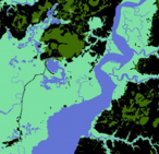
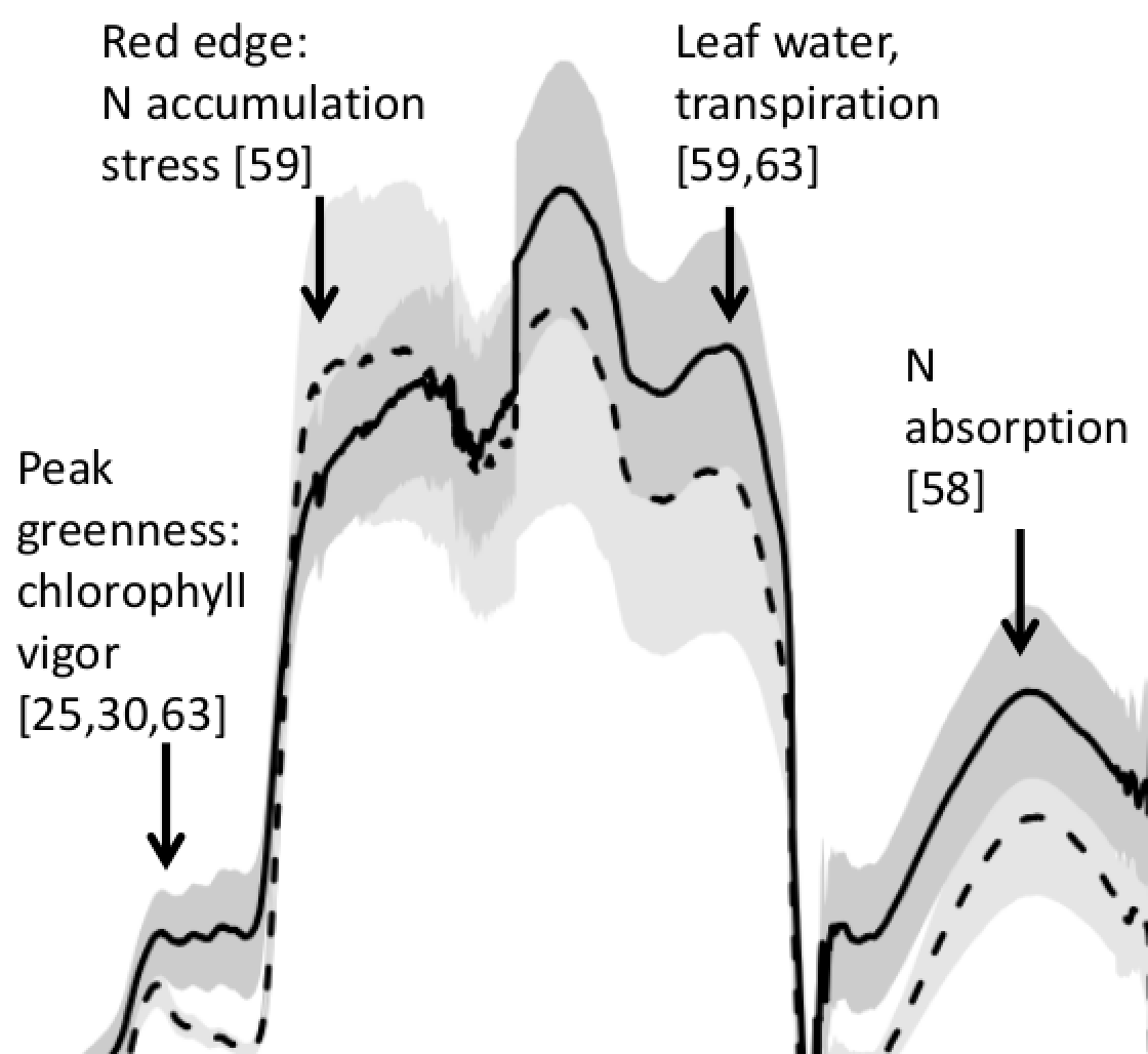
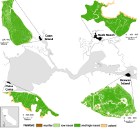
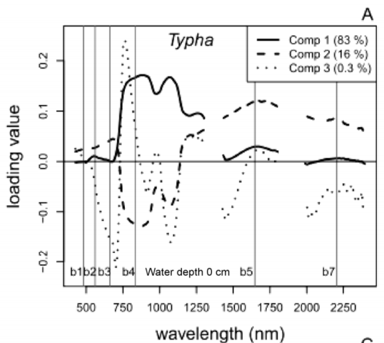
Loadings values of % foliar N from PLS regression of hyperspectral data for Typha spp. Broad-scale estimates of belowground biomass are needed to understand wetland resiliency and C and N cycling, but these estimates are difficult to obtain because root:shoot ratios vary considerably both within and between species. We used remotely-sensed estimates of two aboveground plant characteristics, aboveground biomass and % foliar N to explore biomass allocation in low diversity freshwater impounded peatlands (Sacramento-San Joaquin River Delta, CA, USA). We developed a hybrid modeling approach to relate remotely-sensed estimates of % foliar N (a surrogate for environmental N and plant available nutrients) and aboveground biomass to field-measured belowground biomass for species specific and mixed species models.

Click to read more ...

Monday
Oct052015

The HyspIRI sensor for wetland observation

Turpie, K R, V V Klemas, K Byrd, M Kelly and Y Lo. 2015. Prospective HyspIRI global observations of tidal wetlands Remote Sensing of Environment, 16: 206-217

Tidal wetlands are highly productive and act as critical habitat for a wide variety of plants, fish, shellfish, and other wildlife. These ecotones between aquatic and terrestrial environments also provide protection from storm damage, run-off filtering, and recharge of aquifers. For wetland protection and sensible coastal development, there is a need to monitor these ecosystems at global and regional scales. This paper describes how the HyspIRI hyperspectral and thermal infrared sensors can be used to study and map key ecological properties, such as species composition, biomass, hydrology, and evapotranspiration of tidal salt and brackish marshes and mangroves, and perhaps other major wetland types, including freshwater marshes and wooded/shrub wetlands.

Click to read more ...

Monday
May052014

Mapping wetland biomass with three remote sensors

Byrd, K.B., J.L. O'Connell, S. Di Tommaso, and M. Kelly. 2014. Evaluation of sensor types and environmental controls on mapping biomass of coastal marsh emergent vegetation. Remote Sensing of Environment 149: 166-180

One of our biomass maps, this one from Mayberry slough

We modeled biomass of emergent vegetation with field spectrometer and satellite data from Landsat, Hyperion and WorldView-2 sensors. Use of narrowbands did not significantly improve biomass predictions over broadbands. Water inundation interacting with plant structure controlled biomass model accuracy. Shortwave infrared bands and multi-temporal datasets improved biomass prediction. These types of maps will track Blue Carbon, sea level rise and land use effects in coastal marshes.

Pdf download. Journal link.

Key words: emergent vegetation, hyperspectral sensor, field spectroscopy, multispectral sensor, water inundation, Blue Carbon, wetland management, error reporting.

Monday
Mar102014

Using remote sensing to model biomass accumulation in a wetland plant

Some of the reflectance spectra for S. acutusO’Connell, J.L., K.B. Byrd, M. Kelly. 2014. Remotely-sensed indicators of N-related biomass allocation in Schoenoplectus acutus. PLOS One. 9(3):e90870

Coastal marshes depend on belowground biomass of roots and rhizomes to contribute to peat and soil organic carbon, accrete soil and alleviate flooding as sea level rises. For nutrient-limited plants, eutrophication has either reduced or stimulated belowground biomass depending on plant biomass allocation response to fertilization. Within a freshwater wetland impoundment receiving minimal sediments, we used experimental plots to explore growth models for a common freshwater macrophyte, Schoenoplectus acutus. We used N-addition and control plots (4 each) to test whether remotely-sensed vegetation indices could predict leaf N concentration, root:shoot ratios and belowground biomass of S. acutus. N-addition did not alter whole plant, but reduced belowground biomass 36% and increased aboveground biomass 71%. We correlated leaf N concentration with known N-related spectral regions using all possible normalized difference (ND), simple band ratio (SR) and first order derivative ND (FDN) and SR (FDS) vegetation indices.

Click to read more ...

Friday
Feb142014

SLR and wetlands in the SF Bay

The resilience of four marshes examined in this paper.Schile, L.M., J.C. Callaway, J.T. Morris, D. Stralberg, V. T. Parker, and M. Kelly. 2014. Modeling tidal marsh distribution with sea-level rise: evaluating the role of vegetation and upland habitat in marsh resiliency. PLOS One 9(2): e88760

Tidal marshes maintain elevation relative to sea level through accumulation of mineral and organic matter, yet this dynamic accumulation feedback mechanism has not been modeled widely in the context of accelerated sea-level rise. Uncertainties exist about tidal marsh resiliency to accelerated sea-level rise, reduced sediment supply, reduced plant productivity under increased inundation, and limited upland habitat for marsh migration. We examined marsh resiliency under these uncertainties using the Marsh Equilibrium Model, a mechanistic, elevation-based soil cohort model, using a rich data set of plant productivity and physical properties from sites across the estuarine salinity gradient. Four tidal marshes were chosen along this gradient: two islands and two with adjacent uplands. Varying century sea-level rise (52, 100, 165, 180 cm) and suspended sediment concentrations (100%, 50%, and 25% of current concentrations), we simulated marsh accretion across vegetated elevations for 100 years, applying the results to high spatial resolution digital elevation models to quantify potential changes in marsh distributions.

Click to read more ...

Tuesday
Feb052013

Plant litter influences remote sensing signatures in wetlands

Correlation between fAPAR-hig and two-band vegetation indices usingsimulated Hyperion bands using spectroradiometer data collected at Twitchell IslandSchile, L. K. Byrd, L. Windham-Myers, and M. Kelly. 2013. Accounting for plant litter in remote sensing based estimates of carbon flux in wetlands.  Remote Sensing Letters 4(6):542-551

Monitoring productivity in coastal wetlands is important due to their high carbon sequestration rates and potential role in climate change mitigation. We tested agricultural- and forest-based methods for estimating the fraction of absorbed photosynthetically active radiation (ƒAPAR), a key parameter for modeling gross primary productivity (GPP), in a restored, managed wetland with a dense litter layer of non-photosynthetic vegetation, and we compared the difference in canopy light transmission between a tidally influenced wetland and the managed wetland.

Click to read more ...

Wednesday
Nov162011

Where will SF Bay wetlands be in 100 years?

Stralberg, D., M. Brennan, J. C. Callaway, J. K. Wood, L. M. Schile, D. Jongsomjit, M. Kelly, V. T. Parker, and S. Crooks. 2011. Evaluating tidal marsh sustainability in the face of sea-level rise: a hybrid modeling approach applied to San Francisco Bay. PLoS ONE 6(11): e27388.

Tidal marshes will be threatened by increasing rates of sea-level rise (SLR) over the next century. Managers seek guidance on whether existing and restored marshes will be resilient under a range of potential future conditions, and on prioritizing marsh restoration and conservation activities. Building upon established models, we developed a hybrid approach that involves a mechanistic treatment of marsh accretion dynamics and incorporates spatial variation at a scale relevant for conservation and restoration decision-making. We applied this model to San Francisco Bay, using best-available elevation data and estimates of sediment supply and organic matter accumulation developed for 15 Bay subregions.

Click to read more ...

Friday
May132011

Challenges of measuring methane over peatlands

Baldocchi, D., M. Detto, O. Sonnentag, J. Verfaillie, Y. A. Teh, W. Silver, and M. Kelly. 2012. The challenges of measuring methane fluxes and concentrations over a peatland pasture. Agricultural and Forest Meteorology 153(1): 177-187

We report on methane (CH4) concentrations and efflux densities that were measured over a drained and grazed, peatland pasture in the Sacramento-San Joaquin River Delta of California over a three year period. The site was ideal for micrometeorological flux measurements due to its very flat topography, its exposure to vigorous winds and its extended fetch along the predominant wind direction. Nevertheless, the interpretation of methane fluxes with eddy covariance proved to be extremely complicated by a number of geographical, biophysical, biogeochemical and site management factors.

Keywords: Eddy covariance . Peatland . Wetland . Cattle . Rice . Methane . Laser spectrometer . Biogeochemistry

Tuesday
Feb082011

Greenhouse gas emissions from a temperate peatland pasture

Teh, Y. A., W. L. Silver, O. Sonnentag, M. Detto, M. Kelly, and D. D. Baldocchi. 2011. Large Greenhouse Gas Emissions from a Temperate Peatland Pasture. Ecosystems 14: 311–325

We report greenhouse gas fluxes (CH4, CO2, N2O) from a drained peatland in the Sacramento-San Joaquin River Delta, California, USA currently managed as a rangeland.

Click to read more ...

Monday
Dec272010

Mapping changes in tidal wetland vegetation composition

Tuxen, K, L Schile, D Stralberg, S Siegel, T Parker, M Vasey, J Callaway, and M Kelly. 2011. Mapping changes in tidal wetland vegetation composition and pattern across a salinity gradient using high spatial resolution imagery. Wetland Ecology and Management 19:141-157

Coon Island vegetation over two years. We mapped vegetation at six tidal marshes (two natural, four restored) in the San Francisco Estuary, CA, USA, between 2003 and 2004 using detailed vegetation field surveys and high spatial-resolution color-infrared aerial photography. Vegetation classes were determined by performing hierarchical agglomerative clustering on the field data collected from each tidal marsh.

Click to read more ...