publications by year

Selected Publications

My CV can be found here, my Google Scholar page is here and my Research Gate page is here. Links to directly downloadable papers are provided when possible - these are for individual use only; links to journals are also provided, but might not be available to users without campus library access. All papers are available upon request.

Entries in historic (6)

Sunday
Dec202015

New paper: Challenges and opportunities in synthesizing historical geospatial data 

Eitzel, M V, Kelly, M, Dronova, I, Valachovic, Y, Quinn-Davidson, L, Solera, J, and de Valpine, P. 2016. Challenges and opportunities in synthesizing historical geospatial data using statistical models, Ecological Informatics 31: 100–111
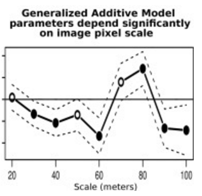
We classified land cover types from 1940s historical aerial imagery using Object Based Image Analysis (OBIA) and compared these maps with data on recent cover. Few studies have used these kinds of maps to model drivers of cover change, partly due to two statistical challenges: 1) appropriately accounting for spatial autocorrelation and 2) appropriately modeling percent cover which is bounded between 0 and 100 and not normally distributed. We studied the change in woody cover at four sites in California’s North Coast using historical (1948) and recent (2009) high spatial resolution imagery.

Click to read more ...

Tuesday
Nov032015

Book chapter: OBIA history and futures

Blaschke, Thomas, Maggi Kelly, and Helena Merschdorf. Object-Based Image Analysis: Evolution, History, State of the Art, and Future Vision. Chapter 14 in Prasad Thenkabail (Editor) Remotely Sensed Data Characterization, Classification, and Accuracies. Taylor & Francis. 678 pp.

More fun with Thomas Blaschke delving into the history of obia and discussing possible new developments. An except of my bit on the Colwell-era antecedants of OBIA: 

The conceptual foundations of OBIA are rooted in the 1960s with predigital aerial photography. e spatial information found in digital imagery that is harnessed in the object-based approach, for example, image texture, contextual information, pixel proximity, and geometric attributes of features, were discussed in the 1960s as possible components to yet possible automation of photo interpretation. In his seminal work on aerial photography and early remote sensing applications, Colwell (1965) describes the photo interpretation process as the act of examining photographic images for the purpose of identifying objects and judging their significance. He said that photo interpretation involves the observation of the size, shape, shadow, tone, texture, pattern, and location of the features, as well as the significance of the features, based largely on their interrelationships or association (Colwell 1965). His assessment of the potential for automation of an object recognition process depended on the capacities of a digital scanner and the ability of an algorithm to assess the differences, in photographic tone, between a "blob" and its surroundings (Colwell 1964, 1965). Colwell was an important advisor on the Landsat 1 mission, and his ideas on extraction of meaningful features transferred to his ambitions for the satellite missions (Colwell 1973). 

Book website.  

Tuesday
Jan202015

20th-century shifts in forest structure in California - evidence from the VTM dataset

McIntyre, P. J., J. H. Thorne, C. R. Dolanc, A. L. Flint, L. E. Flint, M. Kelly and D. D. Ackerly. 2015. Twentieth-century shifts in forest structure in California: Denser forests, smaller trees, and increased dominance of oaks. Proceedings of the National Academy of Sciences 112(5): 1458-1463

change in climate water deficit (left) and change in large trees (right)We document changes in forest structure between historical (1930s) and contemporary (2000s) surveys of California vegetation through comparisons of tree abundance and size across the state and within several ecoregions. Across California, tree density in forested regions increased by 30% between the two time periods, whereas forest biomass in the same regions declined, as indicated by a 19% reduction in basal area. These changes reflect a demographic shift in forest structure: larger trees (>60 cm diameter at breast height) have declined, whereas smaller trees (<30 cm) have increased. Large tree declines were more severe in areas experiencing greater increases in climatic water deficit since the 1930s, based on a hydrologicmodel of water balance for historical climates through the 20th century.

Click to read more ...

Friday
Oct312008

Historic map analysis: spatial error in the CA VTM dataset

Kelly, M., K. Ueda and B. Allen-Diaz. 2008. Considerations for ecological reconstruction of historic vegetation: Analysis of the spatial uncertainties in the California Vegetation Type Map dataset. Plant Ecology 194 (1): 37-49

Uncertainty surrounding plot centersWe examine the spatial uncertainties associated with 18,000 vegetation plots in the VTM dataset that has been digitized for use in modern ecological analysis. We examine the relationship between plot location error and basemap year, basemap scale, plot elevation, plot slope, and general plot habitat type. Pdf download. Journal link.

Keywords: CART . Historical vegetation data . Spatial error . VTM

Friday
Sep302005

Digitization of the Wieslander California vegetation type mapping project

Kelly, M., B. Allen-Diaz, and N. Kobzina. 2005. Digitization of a historic dataset: the Wieslander California vegetation type mapping project. Madroño 52(3):191-201

Scanned VTM plot map

We digitized and made available via the web the plot data and plot locations for the California VTM database. This is a valuable dataset for historical ecological reconstruction. Pdf download.

Key Words: VTM dataset . webGIS . digital database . California plant communities

Wednesday
Jun292005

Decadal changes in a Pacific estuary

Byrd et al. 2005. GIScience and Remote Sensing. We used historic aerial photographs with manual and automated image classification techniques to discern decadal-scale changes to salt marshes in Elkhorn Slough, California caused by off-farm sedimentation from 1971 to 2001. Change detection identified a process of plant succession that led to arroyo willow encroachment into pickleweed marsh.

Click to read more ...