publications by year

Selected Publications

My CV can be found here, my Google Scholar page is here and my Research Gate page is here. Links to directly downloadable papers are provided when possible - these are for individual use only; links to journals are also provided, but might not be available to users without campus library access. All papers are available upon request.

Entries in pattern (8)

Tuesday
Dec092014

Spatial pattern of BMI among adults in Northern California 

Laraia, B. A., S. D. Blanchard, A. J. Karter, J. C. Jones-Smith, M. Warton, E. Kersten, M. Jerrett, H. H. Moffet, N. Adler, D. Schillinger, and M. Kelly. 2014. Spatial pattern of Body Mass Index among adults in the Diabetes Study of Northern California (DISTANCE). International Journal of Health Geographics 13:48 doi:10.1186/1476-072X-13-48
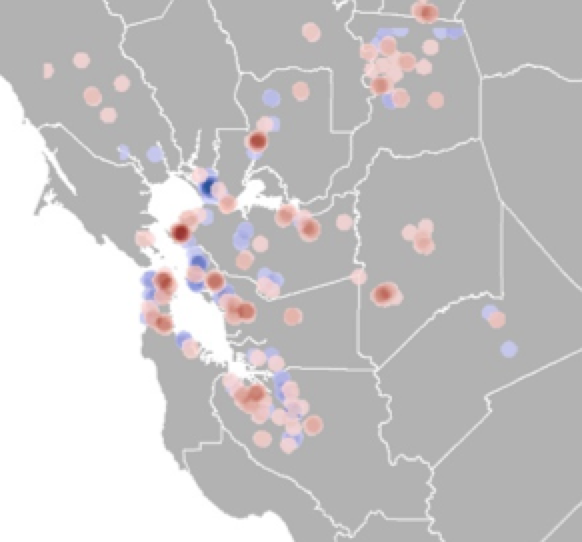
clustering of high and low BMIThe role that environmental factors, such as neighborhood socioeconomics, food, and physical environment, play in the risk of obesity and chronic diseases is not well quantified. Understanding how spatial distribution of disease risk factors overlap with that of environmental (contextual) characteristics may inform health interventions and policies aimed at reducing the environment risk factors.

Click to read more ...

Monday
Dec272010

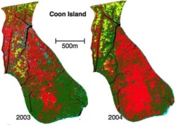
Mapping changes in tidal wetland vegetation composition

Tuxen, K, L Schile, D Stralberg, S Siegel, T Parker, M Vasey, J Callaway, and M Kelly. 2011. Mapping changes in tidal wetland vegetation composition and pattern across a salinity gradient using high spatial resolution imagery. Wetland Ecology and Management 19:141-157

Coon Island vegetation over two years. We mapped vegetation at six tidal marshes (two natural, four restored) in the San Francisco Estuary, CA, USA, between 2003 and 2004 using detailed vegetation field surveys and high spatial-resolution color-infrared aerial photography. Vegetation classes were determined by performing hierarchical agglomerative clustering on the field data collected from each tidal marsh.

Click to read more ...

Friday
Nov122010

Pattern metrics for wetland restoration management

Kelly, M., K. Tuxen and D. Stralberg. 2011. Mapping changes to vegetation pattern in a restoring wetland: Finding pattern metrics that are consistent across spatial scale and time. Ecological Indicators 11: 263-273. We sought to identify pattern metrics that are consistent across spatial scale and time – and thus robust measures of vegetation and habitat configuration – for a restored tidal marsh in the San Francisco Bay, CA, USA.

Click to read more ...

Wednesday
May122010

Predicting bird abundance in tidal marshes

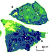
Predicted mean abundance for common yellowthroat at Browns Is. and Sherman Lake

Stralberg, D., M. Herzog, N. Nur, K. Tuxen, S. Siegel and M. Kelly. 2010. Predicting avian abundance within and across tidal marshes using fine-scale vegetation and geomorphic metrics. Wetlands 30: 475-487

We used a blend of fine-scale remote sensing products and field-based survey data via spatial predictive models to aid in monitoring restoring tidal marshes for bird habitat. We developed a suite of 1-m pixel-level spatial metrics describing patterns in marsh vegetation and geomorphology for six sites across a large salinity gradient, and used these to predict avian abundance.

Click to read more ...

Tuesday
Dec312002

Landscape dynamics of the spread of Sudden Oak Death

Kelly and Meentemeyer. 2002. Photogrammetric Engineering and Remote Sensing. We present a landscape-scale We present a landscape-scale study of the spatio-temporal dynamics of oak mortality using second-order spatial point-pattern analysis techniques and classification trees.

Click to read more ...

Saturday
Nov302002

Seagrass landscape pattern and hydrodynamic setting

Fonseca, et al. 2002. Ecological Applications. We examined the coherence of predictions of seagrass cover and ecological attributes of temperate, mixed-species seagrass derived from two common sampling techniques, (video) line transect (commonly used by biologists) and grid-sampled surveys (often used in remote sensing).

Click to read more ...

Monday
Dec312001

Mapping seagrass bed pattern

Kelly, N. M., M. Fonseca, and P. Whitfield. 2001. Aquatic Conservation: Marine and Freshwater Ecosystems. An empirically derived logistic multiple regression model and a Boolean logic suitability model were used to produce several predictive map products, including: susceptibility of seagrasses to storms, probability of seagrass cover, and suitability of areas for restoration of seagrassesin Core Sound, North Carolina, USA.

Click to read more ...

Wednesday
Oct312001

Changes to the landscape pattern of coastal NC wetlands under the Clean Water Act

Kelly, 2001. Landscape Ecology. A collection of Section 404 permits from 1984 through 1992 was analyzed in conjunction with classified Landsat Thematic Mapper data from 1984 and 1992 in order to quantify changes to wetland habitat in the study area in coastal North Carolina.

Click to read more ...