publications by year

Selected Publications

My CV can be found here, my Google Scholar page is here and my Research Gate page is here. Links to directly downloadable papers are provided when possible - these are for individual use only; links to journals are also provided, but might not be available to users without campus library access. All papers are available upon request.

Entries in modeling (14)

Saturday
Mar192016

New paper: Bridging the information gap: A webGIS tool for rural electrification in data-scarce regions

Müller, M F, S E Thompson, and M Kelly. 2016. Bridging the information gap: A webGIS tool for rural electrification in data-scarce regions. Applied Energy 171(1): 277-286

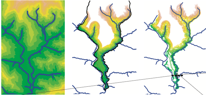
Rural electrification in developing countries is often hampered by major information gaps between local communities and urban centers, where technical expertise and fund- ing are concentrated. The tool presented in this paper addresses these gaps to support the implementation of off-grid micro hydropower infrastructure. Specifically, we present a method to site, size and evaluate the potential for micro hydropower based on re- mote sensing data. The method improves on previous approaches by (i) incorporating the effect of hillslope topography on the optimal layout of the infrastructure, and (ii) accounting for the constraints imposed by streamflow variability and local electricity demand on the optimal size of the plants. An assessment of the method’s performance against 148 existing schemes indicates that it correctly identifies the most promising locations for hydropower in Nepal, but does not generally reproduce the specific design features of constructed plants, which are affected by site-specific constraints. We develop a proof-of-concept computer tool to explore the potential of webGIS technology to account for these constraints by collecting site-specitic information from local users. Journal link

Keywords: Micro hydropower, WebGIS, Nepal, DEM 

Tuesday
Jan202015

20th-century shifts in forest structure in California - evidence from the VTM dataset

McIntyre, P. J., J. H. Thorne, C. R. Dolanc, A. L. Flint, L. E. Flint, M. Kelly and D. D. Ackerly. 2015. Twentieth-century shifts in forest structure in California: Denser forests, smaller trees, and increased dominance of oaks. Proceedings of the National Academy of Sciences 112(5): 1458-1463

change in climate water deficit (left) and change in large trees (right)We document changes in forest structure between historical (1930s) and contemporary (2000s) surveys of California vegetation through comparisons of tree abundance and size across the state and within several ecoregions. Across California, tree density in forested regions increased by 30% between the two time periods, whereas forest biomass in the same regions declined, as indicated by a 19% reduction in basal area. These changes reflect a demographic shift in forest structure: larger trees (>60 cm diameter at breast height) have declined, whereas smaller trees (<30 cm) have increased. Large tree declines were more severe in areas experiencing greater increases in climatic water deficit since the 1930s, based on a hydrologicmodel of water balance for historical climates through the 20th century.

Click to read more ...

Wednesday
Dec312014

Agave production as a bioenergy feedstock: a fuzzy GIS model

Fuzzy GIS model for A. tequilaLewis, S., S. Gross, A. Visel, M. Kelly, and W. Morrow. 2015. Fuzzy GIS-based multi-criteria evaluation for U.S. Agave production as a bioenergy feedstock. Global Change Biology - Bioenergy 7:84–99. doi: 10.1111/gcbb.12116

In the United States, renewable energy mandates calling for increased production of cellulosic biofuels will require a diversity of bioenergy feedstocks to meet growing demands. Within the suite of potential energy crops, plants within the genus Agave promise to be a productive feedstock in hot and arid regions. The potential distributions of Agave tequilana and Agave deserti in the United States were evaluated based on plant growth parameters identified in an extensive literature review. A geospatial suitability model rooted in fuzzy logic was developed that utilized a suite of biophysical criteria to optimize ideal geographic locations for this new crop, and several suitability scenarios were tested for each species. The results of this spatially explicit suitability model suggest that there is potential for Agave to be grown as an energy feedstock in the southwestern region of the United States – particularly in Arizona, California, and Texas – and a significant portion of these areas are proximate to existing transportation infrastructure.

Click to read more ...

Monday
May052014

Mapping wetland biomass with three remote sensors

Byrd, K.B., J.L. O'Connell, S. Di Tommaso, and M. Kelly. 2014. Evaluation of sensor types and environmental controls on mapping biomass of coastal marsh emergent vegetation. Remote Sensing of Environment 149: 166-180

One of our biomass maps, this one from Mayberry slough

We modeled biomass of emergent vegetation with field spectrometer and satellite data from Landsat, Hyperion and WorldView-2 sensors. Use of narrowbands did not significantly improve biomass predictions over broadbands. Water inundation interacting with plant structure controlled biomass model accuracy. Shortwave infrared bands and multi-temporal datasets improved biomass prediction. These types of maps will track Blue Carbon, sea level rise and land use effects in coastal marshes.

Pdf download. Journal link.

Key words: emergent vegetation, hyperspectral sensor, field spectroscopy, multispectral sensor, water inundation, Blue Carbon, wetland management, error reporting.

Monday
Mar312014

What is "marginal land"? a review of the ways GIS is used to model (and define) "marginal land" for biofuel production

Lewis, S. and M. Kelly. 2014. Mapping the potential for biofuel production on marginal lands: differences in definitions, data and models across scale. International Journal of Geo-Information 3(2), 430-459; doi:10.3390/ijgi3020430

As energy policies mandate increases in bioenergy production, new research supports growing bioenergy feedstocks on marginal lands. Subsequently there has been an increase in published work that uses Geographic Information Systems (GIS) to map the availability of marginal land as a proxy for bioenergy crop potential. However, despite the similarity in stated intent among these works a number of inconsistencies remain across studies that make comparisons and standardization difficult. We reviewed a collection of recent literature that mapped bioenergy potential on marginal lands at varying scales, and found that there is no common working definition of marginal land across all of these works. Specifically we found considerable differences in mapped results that are driven by dissimilarities in definitions, model framework, data inputs, scale and treatment of uncertainty.

Click to read more ...

Thursday
Mar062014

Mapping potential for switchgrass as a biofuel in the US

One model outcome from the analysis.Lewis, S.M., G. Fitts, M. Kelly, L. Dale. 2014. A fuzzy logic-based spatial suitability model for drought-tolerant switchgrass in the United States. Computers and Electronics in Agriculture 103:39-47

Switchgrass (Panicum virgatum) has been targeted by the U.S. Department of Agriculture as an exemplary bioenergy crop, however it requires a significant amount of water and experiences reduced yields in water-stressed conditions. To avoid competition for prime agricultural areas, lands that receive adequate rainfall but are marginal due to highly variable timing of rain are potentially ideal locations to grow drought-tolerant biofuels. As scientists develop a modified variety of switchgrass that can withstand periods of drought while not substantially affecting overall yield, it is important to identify the potential geographical niche for this xerophytic crop to maximize its environmental and economic sustainability. This project uses a spatial suitability modeling approach that incorporates fuzzy logic and utilizes both physical and economic variables.

Click to read more ...

Friday
Feb142014

SLR and wetlands in the SF Bay

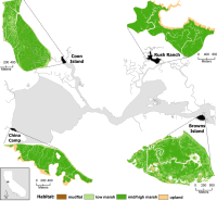
The resilience of four marshes examined in this paper.Schile, L.M., J.C. Callaway, J.T. Morris, D. Stralberg, V. T. Parker, and M. Kelly. 2014. Modeling tidal marsh distribution with sea-level rise: evaluating the role of vegetation and upland habitat in marsh resiliency. PLOS One 9(2): e88760

Tidal marshes maintain elevation relative to sea level through accumulation of mineral and organic matter, yet this dynamic accumulation feedback mechanism has not been modeled widely in the context of accelerated sea-level rise. Uncertainties exist about tidal marsh resiliency to accelerated sea-level rise, reduced sediment supply, reduced plant productivity under increased inundation, and limited upland habitat for marsh migration. We examined marsh resiliency under these uncertainties using the Marsh Equilibrium Model, a mechanistic, elevation-based soil cohort model, using a rich data set of plant productivity and physical properties from sites across the estuarine salinity gradient. Four tidal marshes were chosen along this gradient: two islands and two with adjacent uplands. Varying century sea-level rise (52, 100, 165, 180 cm) and suspended sediment concentrations (100%, 50%, and 25% of current concentrations), we simulated marsh accretion across vegetated elevations for 100 years, applying the results to high spatial resolution digital elevation models to quantify potential changes in marsh distributions.

Click to read more ...

Wednesday
Nov162011

Where will SF Bay wetlands be in 100 years?

Stralberg, D., M. Brennan, J. C. Callaway, J. K. Wood, L. M. Schile, D. Jongsomjit, M. Kelly, V. T. Parker, and S. Crooks. 2011. Evaluating tidal marsh sustainability in the face of sea-level rise: a hybrid modeling approach applied to San Francisco Bay. PLoS ONE 6(11): e27388.

Tidal marshes will be threatened by increasing rates of sea-level rise (SLR) over the next century. Managers seek guidance on whether existing and restored marshes will be resilient under a range of potential future conditions, and on prioritizing marsh restoration and conservation activities. Building upon established models, we developed a hybrid approach that involves a mechanistic treatment of marsh accretion dynamics and incorporates spatial variation at a scale relevant for conservation and restoration decision-making. We applied this model to San Francisco Bay, using best-available elevation data and estimates of sediment supply and organic matter accumulation developed for 15 Bay subregions.

Click to read more ...

Wednesday
Jun012011

Cal-adapt is PE&RS cover story

June 2011 cover story on cal-adaptKoy,
 K.,
 S.
 V.
 Wart,
 B. Galey, 
M. 
O’Connor, 
and 
M. 
Kelly. 2011. 
Cal‐Adapt:
 Bringing
 global 
climate 
change 
data 
to 
local
 application. Photogrammetric Engineering and Remote Sensing 77(6): 546-550

June's PE&RS cover story features the Cal-Adapt web application developed by the GIF.  Cal-adapt has been developed to showcase the wealth of innovative climate change research being produced by the scientific community in California, as documented in the 2009 California Climate Adaptation Strategy. Through a combination of locally relevant information, visualization tools, and access to primary data, Cal-Adapt allows users to investigate how the climate is projected to change in their area of interest, and gives them tools to plan for these changes.

Our article can be found here.

Sunday
Sep302007

Modeling SOD risk in the United States

Kelly, et al. 2007. Computers, Environment and Urban Systems. Risk for SOD in the southeast based on model agreementUsing the locations of P. ramorum in CA we derived a risk map for SOD spread in the conterminous US using 5 environmental niche models: Expert-driven Rule-based, Logistic Regression, Classification and Regression Trees, Genetic Algorithms, and Support Vector Machines.

Click to read more ...

Errors occurred while processing template[pageRendered/journal.st]:
StringTemplate Error: Can't parse chunk: {settingHomePageKBArticle}" target="_blank">Learn how.</a></li>
<li>If you have already selected a front page, make sure it is enabled. Click on the Cubes icon (top right) and then click the "enable page" button.</li>
</ol>
</div>

: expecting '"', found '<EOF>'
StringTemplate Error: problem parsing template 'pageRendered/noDefaultModule': null