publications by year

Selected Publications

My CV can be found here, my Google Scholar page is here and my Research Gate page is here. Links to directly downloadable papers are provided when possible - these are for individual use only; links to journals are also provided, but might not be available to users without campus library access. All papers are available upon request.

Entries in oaks (21)

Sunday
Dec202015

New paper: Challenges and opportunities in synthesizing historical geospatial data 

Eitzel, M V, Kelly, M, Dronova, I, Valachovic, Y, Quinn-Davidson, L, Solera, J, and de Valpine, P. 2016. Challenges and opportunities in synthesizing historical geospatial data using statistical models, Ecological Informatics 31: 100–111
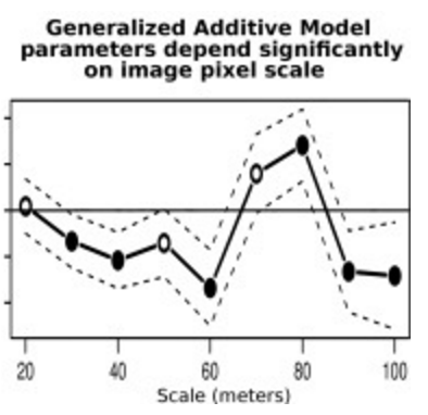
We classified land cover types from 1940s historical aerial imagery using Object Based Image Analysis (OBIA) and compared these maps with data on recent cover. Few studies have used these kinds of maps to model drivers of cover change, partly due to two statistical challenges: 1) appropriately accounting for spatial autocorrelation and 2) appropriately modeling percent cover which is bounded between 0 and 100 and not normally distributed. We studied the change in woody cover at four sites in California’s North Coast using historical (1948) and recent (2009) high spatial resolution imagery.

Click to read more ...

Tuesday
Jan202015

20th-century shifts in forest structure in California - evidence from the VTM dataset

McIntyre, P. J., J. H. Thorne, C. R. Dolanc, A. L. Flint, L. E. Flint, M. Kelly and D. D. Ackerly. 2015. Twentieth-century shifts in forest structure in California: Denser forests, smaller trees, and increased dominance of oaks. Proceedings of the National Academy of Sciences 112(5): 1458-1463

change in climate water deficit (left) and change in large trees (right)We document changes in forest structure between historical (1930s) and contemporary (2000s) surveys of California vegetation through comparisons of tree abundance and size across the state and within several ecoregions. Across California, tree density in forested regions increased by 30% between the two time periods, whereas forest biomass in the same regions declined, as indicated by a 19% reduction in basal area. These changes reflect a demographic shift in forest structure: larger trees (>60 cm diameter at breast height) have declined, whereas smaller trees (<30 cm) have increased. Large tree declines were more severe in areas experiencing greater increases in climatic water deficit since the 1930s, based on a hydrologicmodel of water balance for historical climates through the 20th century.

Click to read more ...

Saturday
Jan212012

How do forest and rangeland owners in California get information about environmental sustainability?

Ferranto, S., L. Huntsinger, C. Getz, W. Stewart, G. Nakamura, and M. Kelly. 2012. Consider the source: The impact of media and authority in outreach to California’s forest and rangeland owners. Journal of Environmental Management 97(1): 131-140.

Over half of the United States is privately owned. Improving environmental sustainability requires that the scientific and management communities provide effective outreach to the many landowners making decisions about land use and management practices on these lands. We surveyed California forest and rangeland owners in ten counties throughout the state to assess the impact of existing outreach and identify gaps in information distribution and content. Although a number of organizations provide land management advice highly-ranked by landowners, no individual organization currently reaches more than 30% of forest and rangeland owners, and these groups together reach less than 60% of landowners.

Click to read more ...

Thursday
Apr282011

Oakmapper: citizen science, webGIS, and volunteered information

Connors, J., S. Lei and M. Kelly. 2012. Citizen science in the age of neogeography: utilizing volunteered geographic information for environmental monitoring. Annals of the Association of American Geographers 102(6): 1267-1289

The interface between neogeography and citizen science has great potential for environmental monitoring, but this nexus has been explored less often than each subject individually. In this article we review the emerging role of volunteered geographic information in citizen science, and present a case study of an integrated toolset that engages multiple types of users (from targeted citizen-based observation networks, expert-driven focused monitoring, and opportunistic crowdsourcing efforts) in monitoring a forest disease in the western U.S.

Click to read more ...

Monday
May102010

Survival of oaks and tanoaks after 8 years of SOD monitoring

McPherson, B. M., D. L. Wood, S. Mori, M. Kelly, A. J. Storer, P. Svihra, and R. B. Standiford. 2010. Survival of oaks and tanoaks after eight years of sudden oak death monitoring in coastal California. Forest Ecology and Management 259: 2248-2255

We report on the survival of trees (coast live oaks, black oaks, and tanoaks) in long-term SOD monitoring plots in Marin County.

Click to read more ...

Sunday
May092010

Urban influence on changes in linear forest edge structure

De Chant, T., A. H. Gallego, J. V. Saornil and M. Kelly. 2010. Urban influence on changes in linear forest edge structure. Landscape and Urban Planning 96: 12-18

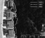
An example of changing edge sinuosity We studied how forest edges at two California coastal oak woodlands (Pacheco Valle and China Camp) in the San Francisco Bay Area in California changed in the decades following urbanization using remote sensing and object based image analysis.

Click to read more ...

Thursday
Dec312009

Individual object change detection for hardwood forest disease monitoring

De Chant, T. and M. Kelly. 2009. Individual object change detection for monitoring the impact of a forest pathogen on a hardwood forest. Photogrammetric Engineering and Remote Sensing 75(8): 1005-1014

Using 4-band, 1 m spatial resolution aerial photography, we classified four annual images (2000 to 2003) with object-based image analysis and employed a GIS for our change detection technique to follow the fate of forest gaps caused by sudden oak death.

Click to read more ...

Wednesday
Dec312008

Spatial pattern dynamics of oak mortality & disease symptoms

Kelly et al. 2008. Journal of Forest Research. We used two-dimensional spatial analysis tools with data gathered in point-centered-quarter format in 2001 and 2004 to quantify 1) population density of the disease through time; 2) spatial pattern of tree mortality across scales through time; and 3) spatial co-occurrence of disease symptoms with crown mortality through time.

Click to read more ...

Wednesday
Jul302008

Oak health and leaf spectral response

Pu et al. 2008. GeoCarto International. The spectroscopic determination of two health levels of the coast live oak leaves was conducted with three sets of spectra. Based on our experimental results and previous work, existing remote sensing techniques, including airborne or satellite remote sensing and multispectral or hyperspectral remote sensing, may be insufficient for monitoring and mapping disease-induced moisture stress in trees that have recently been infected.

Click to read more ...

Saturday
May312008

Mapping SOD related stress with CASI

Pu, R., M. Kelly, G. L. Anderson, and P. Gong. 2008. Using CASI hyperspectral imagery to detect mortality and vegetation stress associated with a new hardwood forest disease. Photogrammetric Engineering & Remote Sensing 74(1): 65‐75

A CASI dataset was used for detecting mortality and vegetation stress associated with a new forest disease. Pdf download.