publications by year

Selected Publications

My CV can be found here, my Google Scholar page is here and my Research Gate page is here. Links to directly downloadable papers are provided when possible - these are for individual use only; links to journals are also provided, but might not be available to users without campus library access. All papers are available upon request.

Tuesday
Aug162011

Understanding how California's forest and rangeland owners value land

Ferranto, S., L. Huntsinger, C. Getz, G. Nakamura, W. Stewart, S. Drill, Y. Valachovic, M. DeLasaux and M. Kelly. 2012. Forest and rangeland owners value land for natural amenities, and as financial investment. California Agriculture 65(4): 184-191

Forty-two percent of California’s forests and rangelands are privately owned. These lands provide important ecosystem services such as carbon sequestration, wildlife habitat, and pollination services, but little is known about the people who own and manage them. We surveyed forest and rangeland owners in California, and found that these long-time landowners value their properties for their natural amenities and as a financial investment.

Click to read more ...

Wednesday
Jun012011

Cal-adapt is PE&RS cover story

June 2011 cover story on cal-adaptKoy,
 K.,
 S.
 V.
 Wart,
 B. Galey, 
M. 
O’Connor, 
and 
M. 
Kelly. 2011. 
Cal‐Adapt:
 Bringing
 global 
climate 
change 
data 
to 
local
 application. Photogrammetric Engineering and Remote Sensing 77(6): 546-550

June's PE&RS cover story features the Cal-Adapt web application developed by the GIF.  Cal-adapt has been developed to showcase the wealth of innovative climate change research being produced by the scientific community in California, as documented in the 2009 California Climate Adaptation Strategy. Through a combination of locally relevant information, visualization tools, and access to primary data, Cal-Adapt allows users to investigate how the climate is projected to change in their area of interest, and gives them tools to plan for these changes.

Our article can be found here.

Wednesday
Jun012011

Influence of neighborhood food stores on girls’ BMI

Leung, CH, BA Laraia, M Kelly, D Nickleach, NE Adler, LH Kushi, and IH Yen. 2011. Effects of Neighborhood Food Store Availability on Young Girls' Body Mass Index. American Journal of Preventative Medicine 41(1): 43–51

This exploratory study examined the relationship between the presence of neighborhood food stores within a girl’s neighborhood and 3-year risk of overweight/obesity and change in BMI, in girls aged 6 or 7 years at baseline. Availability of convenience stores within a 0.25-mile network  buffer of a girl’s residence was associated with greater risk of overweight/obesity and an increase in BMI z-score. Availability of produce vendors/farmer’s markets within a 1.0-mile network buffer of a girl’s residence was inversely associated with overweight/obesity.

Click to read more ...

Friday
May132011

Challenges of measuring methane over peatlands

Baldocchi, D., M. Detto, O. Sonnentag, J. Verfaillie, Y. A. Teh, W. Silver, and M. Kelly. 2012. The challenges of measuring methane fluxes and concentrations over a peatland pasture. Agricultural and Forest Meteorology 153(1): 177-187

We report on methane (CH4) concentrations and efflux densities that were measured over a drained and grazed, peatland pasture in the Sacramento-San Joaquin River Delta of California over a three year period. The site was ideal for micrometeorological flux measurements due to its very flat topography, its exposure to vigorous winds and its extended fetch along the predominant wind direction. Nevertheless, the interpretation of methane fluxes with eddy covariance proved to be extremely complicated by a number of geographical, biophysical, biogeochemical and site management factors.

Keywords: Eddy covariance . Peatland . Wetland . Cattle . Rice . Methane . Laser spectrometer . Biogeochemistry

Thursday
Apr282011

Oakmapper: citizen science, webGIS, and volunteered information

Connors, J., S. Lei and M. Kelly. 2012. Citizen science in the age of neogeography: utilizing volunteered geographic information for environmental monitoring. Annals of the Association of American Geographers 102(6): 1267-1289

The interface between neogeography and citizen science has great potential for environmental monitoring, but this nexus has been explored less often than each subject individually. In this article we review the emerging role of volunteered geographic information in citizen science, and present a case study of an integrated toolset that engages multiple types of users (from targeted citizen-based observation networks, expert-driven focused monitoring, and opportunistic crowdsourcing efforts) in monitoring a forest disease in the western U.S.

Click to read more ...

Friday
Apr082011

Tracking the structural and functional development of a perennial pepperweed 

Sonnentag O, Vargas R, Detto M, Runkle BRK, Kelly M, and Baldocchi DD. 2011. Tracking the structural and functional development of a perennial pepperweed (Lepidium latifolium L.) infestation using a multi-year archive of webcam imagery and eddy covariance measurements. Agricultural Forest Meteorology: 151:916-926

We explore the ability of red (R)–green (G)–blue (B) color space information to track the structural and functional development of a perennial pepperweed (Lepidium latifolium L.) infestation in California.

Click to read more ...

Tuesday
Feb082011

Greenhouse gas emissions from a temperate peatland pasture

Teh, Y. A., W. L. Silver, O. Sonnentag, M. Detto, M. Kelly, and D. D. Baldocchi. 2011. Large Greenhouse Gas Emissions from a Temperate Peatland Pasture. Ecosystems 14: 311–325

We report greenhouse gas fluxes (CH4, CO2, N2O) from a drained peatland in the Sacramento-San Joaquin River Delta, California, USA currently managed as a rangeland.

Click to read more ...

Monday
Dec272010

Mapping changes in tidal wetland vegetation composition

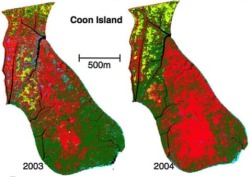
Tuxen, K, L Schile, D Stralberg, S Siegel, T Parker, M Vasey, J Callaway, and M Kelly. 2011. Mapping changes in tidal wetland vegetation composition and pattern across a salinity gradient using high spatial resolution imagery. Wetland Ecology and Management 19:141-157

Coon Island vegetation over two years. We mapped vegetation at six tidal marshes (two natural, four restored) in the San Francisco Estuary, CA, USA, between 2003 and 2004 using detailed vegetation field surveys and high spatial-resolution color-infrared aerial photography. Vegetation classes were determined by performing hierarchical agglomerative clustering on the field data collected from each tidal marsh.

Click to read more ...

Friday
Dec172010

Carbon dioxide exchange of a pepperweed infestation

Sonnentag, O., M. Detto, B. Runkle, Y. Teh, W. Silver, M. Kelly, and D. D. Baldocchi. 2011. Carbon dioxide exchange of a pepperweed (Lepidium latifolium L.) infestation: how do flowering and mowing affect canopy photosynthesis and autotrophic respiration? J. Geophys. Res., 116, G01021, doi:10.1029/2010JG001522

We analyzed CO2 flux measurements made with eddy covariance over a pepperweed infestation in California, covering three growing seasons. We found that unmowed pepperweed caused the site to be almost CO2 neutral or a net source, and mowing during early flowering caused the site to act as a net CO2 sink.

Click to read more ...

Friday
Nov122010

Pattern metrics for wetland restoration management

Kelly, M., K. Tuxen and D. Stralberg. 2011. Mapping changes to vegetation pattern in a restoring wetland: Finding pattern metrics that are consistent across spatial scale and time. Ecological Indicators 11: 263-273. We sought to identify pattern metrics that are consistent across spatial scale and time – and thus robust measures of vegetation and habitat configuration – for a restored tidal marsh in the San Francisco Bay, CA, USA.

Click to read more ...

Page 1 ... 4 5 6 7 8 ... 11 Next 10 Entries »