publications by year

Selected Publications

My CV can be found here, my Google Scholar page is here and my Research Gate page is here. Links to directly downloadable papers are provided when possible - these are for individual use only; links to journals are also provided, but might not be available to users without campus library access. All papers are available upon request.

Sunday
Apr292007

Watershed land use and wetland disturbance

Byrd, et al. 2007. Environmental Management. 
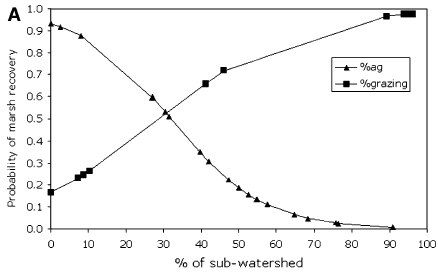
We show that salt marsh recovery after disturbance depends on relative cover of different land use classes in the watershed, with greater chances of recovery associated with less intensive agriculture.

Click to read more ...

Friday
Mar302007

Upland land use influence on wetlands

Byrd and Kelly 2006. Wetlands. This study investigated how changes in salt marsh soil properties and topography on sediment fans related to shifts in salt marsh plant community composition in the Elkhorn Slough Watershed, California, USA.

Click to read more ...

Sunday
Dec312006

Automatic registration of airborne images

Liu, et al. 2006. Photogrammetric Engineering and Remote Sensing. Deformation vector plots overlaid on areas with high and low texture.Accurate registration of airborne images is challenging because complex local geometric distortions are often involved in image acquisition. We propose a solution to this registration problem in two parts: 1) an area-based method to extract sufficient numbers of well-located control points, 2) we use the extracted control points with local transformation models to register multi-temporal airborne images.

Click to read more ...

Tuesday
Oct312006

Isolating individual trees in a savanna woodland using lidar

Chen et al. 2006. Photogrammetric Engineering and Remote Sensing. Individual trees delineated.This study presents a new method of detecting individual treetops from lidar data and applies marker-controlled watershed segmentation into isolating individual trees in savanna woodland. The treetops were detected by searching local maxima in a canopy maxima model (CMM) with variable window sizes.

Click to read more ...

Thursday
Aug312006

Spatial analysis of air toxics in West Oakland, CA

Fisher, et al. 2006. Health and Place. This paper examines the spatial point pattern of industrial toxic substances and the associated environmental justice implications in the San Francisco Bay Area, California, USA. Using a spatial analysis method called Ripley’s K we assess environmental justice across multiple spatial scales, and we verify and quantify the West Oakland neighborhood as an environmental justice site as designated by the US Environmental Protection Agency.

Click to read more ...

Monday
Jul312006

Obia for detailed vegetation mapping

Yu et al. 2006. Photogrammetric Engineering and Remote Sensing. In this paper, we evaluate the capability of the high spatial resolution airborne Digital Airborne Imaging System (DAIS) imagery for detailed vegetation classification at the alliance level with the aid of ancillary topographic data. Image objects as minimum classification units were generated through the Fractal Net Evolution Approach (FNEA) segmentation using eCognition software. For each object, 52 features were calculated including spectral features, textures, topographic features, and geometric features. After statistically ranking the importance of these features with the classification and regression tree algorithm (CART), the most effective features for classification were used to classify the vegetation.

Click to read more ...

Wednesday
May312006

Spatial‐temporal monitoring of forest disease dynamics

Liu et al. 2006. Remote Sensing of Environment. Traditional mapping approaches using per-pixel, single-date image classifications have not generated consistently satisfactory results. Incorporation of spatial–temporal contextual information can improve these results. In this paper, we propose a spatial–temporally explicit algorithm to classify individual images using the spectral and spatial–temporal information derived from multiple co-registered images.

Click to read more ...

Saturday
Dec312005

Watershed-scale land use and salmon habitat

Opperman, et al. 2005. Canadian Journal of Fisheries and Aquatic Science. Relationships between land use or land cover and embeddedness, a measure of fine sediment in spawning gravels, were examined at multiple scales across 54 streams in the Russian River Basin, California. The results suggest that coarse-scale measures of watershed land use can explain a large proportion of the variability in embeddedness and that the explanatory power of this relationship increases with watershed size.

Click to read more ...

Friday
Sep302005

Digitization of the Wieslander California vegetation type mapping project

Kelly, M., B. Allen-Diaz, and N. Kobzina. 2005. Digitization of a historic dataset: the Wieslander California vegetation type mapping project. Madroño 52(3):191-201

Scanned VTM plot map

We digitized and made available via the web the plot data and plot locations for the California VTM database. This is a valuable dataset for historical ecological reconstruction. Pdf download.

Key Words: VTM dataset . webGIS . digital database . California plant communities

Wednesday
Aug312005

Sudden oak death disease progression in oaks and tanoaks

McPherson, B. A. S. Mori, D. L. Wood, A. J. Storer, P. Švihra, N. M. Kelly and R. B. Standiford. 2005. Sudden oak death in California: Disease progression in oaks and tanoaks. Journal of Forest Ecology and Management 213(1-3): 71-89