publications by year

Selected Publications

My CV can be found here, my Google Scholar page is here and my Research Gate page is here. Links to directly downloadable papers are provided when possible - these are for individual use only; links to journals are also provided, but might not be available to users without campus library access. All papers are available upon request.

Wednesday
Jun242015

Mapping discussions about forests and forest management

Lei, S. and M. Kelly. 2015. Evaluating adaptive collaborative management in Sierra Nevada forests by exploring public meeting dialogues using Self-Organizing Maps. Society and Natural Resources (28)8: 873-890

Heat map of discussion in SNAMP meetings: red conveys most consistently discussed topics; blue conveys least consistently discussedCollaborative adaptive management (CAM) is an appropriate management regime for social-ecological systems because it aims to reduce management uncertainties and fosters collaboration among diverse stakeholders. We evaluate the effectiveness of CAM in fostering collaboration among contentious multiparty environmental stakeholders based the Sierra Nevada Adaptive Management Project (SNAMP). Our evaluation focuses on facilitated public multiparty discussions (2005-2012). Self-organizing maps (SOM), an unsupervised machine-learning method, were used to process, organize, and visualize the public meeting notes.

Click to read more ...

Monday
May042015

Mapping forests with Lidar: a review highlighting the California perspective

Kelly, M. and S. Di Tommaso. 2015. Mapping forests with Lidar provides flexible, accurate data with many uses. California Agriculture 69(1): 14-20

The use of remote sensing for forest inventory, fire management, and wildlife habitat conservation planning has a decades-long and productive history, especially in California. The history of forest remote sensing in California follows a transition from aerial photography to digital remote sensing, in which Landsat plays a significant role, and today shows an increasing reliance on Lidar analysis. In California where forests are complex and difficult to accurately map, numerous remote sensing scientists have pioneered development of methodologies for forest mapping with Lidar.

Click to read more ...

Sunday
Apr192015

Tracking information production and use in adaptive management

Lei, S., A. Iles, and M. Kelly. 2015. Characterizing the networks of digital information that support collaborative adaptive forest management in Sierra Nevada forests. Environmental Management 56(1): 94-109

Tracking where some of our lidar papers are being citedSome of the factors that can contribute to the success of collaborative adaptive management – such as social learning, open communication, and trust - are built upon a foundation of the open exchange of information about science and management between participants and the public.  Despite the importance of information transparency, the use and flow of information in collaborative adaptive management has not been characterized in detail in the literature, and currently there exist opportunities to develop strategies for increasing the exchange of information, as well as to track information flow in such contexts. We use powerful new information monitoring tools to characterize information products generated in the SNAMP program through their production, transport, use, and monitoring.

Click to read more ...

Saturday
Apr112015

Food vendors, neighborhood deprivation, and BMI

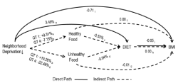
Zhang, YT, BA Laraia, MS Mujahid, A Tamayo, SD Blanchard, EM Warton, NM Kelly, HH Moffet, D Schillinger, N Adler, and AJ Karter. 2015. Does food vendor density mediate the association between neighborhood deprivation and BMI?: A G-computation mediation analysis. Epidemiology 26(3):344-52

In previous research, neighborhood deprivation was positively associated with body mass index (BMI) among adults with diabetes. We assessed whether the association between neighborhood deprivation and BMI is attributable, in part, to geographic variation in the availability of healthful and unhealthful food vendors. Subjects were 16,634 participants of the Diabetes Study of Northern California. Neighborhood deprivation and healthful (supermarket and produce) and unhealthful (fast food outlets and convenience stores) food vendor kernel density were calculated at each participant's residential block centroid. Availability of food vendors, both healthful and unhealthful, did not appear to explain the association between neighborhood deprivation and BMI in this population of adults with diabetes.

Click to read more ...

Friday
Apr102015

Lidar + MODIS to upscale predictions of forest biomass

Li, L., Q. Guo, S. Tao, M. Kelly, and G. Xu. 2015. Lidar with multi-temporal MODIS provide a means to upscale predictions of forest biomass. ISPRS Journal of Photogrammetry and Remote Sensing. 102: 198–208

Forests play a key role in the global carbon cycle, and forest above ground biomass (AGB) is an important indictor to the carbon storage capacity and the potential carbon pool size of a forest ecosystem. Accurate estimation of forest AGB has become increasingly important for a wide range of end-users. Although satellite remote sensing provides abundant observations to monitor forest coverage, validation of coarse-resolution AGB derived from satellite observations is difficult because of the scale mismatch between the footprints of satellite observations and field measurements. In this study, we use airborne Lidar to bridge the scale gaps between satellite-based and field-based studies, and evaluate satellite-derived indices to estimate regional forest AGB.

Click to read more ...

Wednesday
Feb252015

Teleconnections between land use and wildfire

Butsic, V., M. Kelly and M. A. Moritz. Land Use and Wildfire: A Review of Local Interactions and Teleconnections. Land 2015, 4(1), 140-156; doi:10.3390/land4010140

Fire is a naturally occurring process of most terrestrial ecosystems as well as a tool for changing land use. Since the beginning of history humans have used fire as a mechanism for creating areas suitable for agriculture and settlement. As fires threaten human dominated landscapes, fire risk itself has become a driver of landscape change, impacting landscapes through land use regulations and fire management. Land use changes also influence fire ignition frequency and fuel loads and hence alters fire regimes. The impact of these changes is often exacerbated as new land users demand alternative fire management strategies, which can impact land cover and management far from where land use change has actually occurred. This creates nuanced land use teleconnections between source areas for fires and economic cores, which demand and fund fire protection.

Click to read more ...

Tuesday
Jan202015

20th-century shifts in forest structure in California - evidence from the VTM dataset

McIntyre, P. J., J. H. Thorne, C. R. Dolanc, A. L. Flint, L. E. Flint, M. Kelly and D. D. Ackerly. 2015. Twentieth-century shifts in forest structure in California: Denser forests, smaller trees, and increased dominance of oaks. Proceedings of the National Academy of Sciences 112(5): 1458-1463

change in climate water deficit (left) and change in large trees (right)We document changes in forest structure between historical (1930s) and contemporary (2000s) surveys of California vegetation through comparisons of tree abundance and size across the state and within several ecoregions. Across California, tree density in forested regions increased by 30% between the two time periods, whereas forest biomass in the same regions declined, as indicated by a 19% reduction in basal area. These changes reflect a demographic shift in forest structure: larger trees (>60 cm diameter at breast height) have declined, whereas smaller trees (<30 cm) have increased. Large tree declines were more severe in areas experiencing greater increases in climatic water deficit since the 1930s, based on a hydrologicmodel of water balance for historical climates through the 20th century.

Click to read more ...

Saturday
Jan172015

Monitoring residual dry matter on rangelands with remote sensing

Tsalyuk, M., M. Kelly, K. Koy, W. M. Getz, and H. S. Butterfield. 2015. Monitoring the Impact of Grazing on Rangeland Conservation Easements Using MODIS Vegetation Indices. Rangeland Ecology and Management  68(2): 173–185

Residual dry matter (RDM), the dry grass biomass left on the ground in the fall, is a widely used proxy for rangeland conditions. We developed a method to efficiently monitor RDM using time series of three Moderate Resolution Imaging Spectroradiometer (MODIS) satellite-based vegetation indices (VIs). We found a significant correlation between RDM and the VIs, especially the Leaf Area Index (LAI), which predicts compliance with RDM conservation easement terms.  Our rangeland management model uses time series of MODIS VIs to predict forage quantities, manage stocking rates, and monitor rangeland easement compliance, efficiently, rapidly, and reliably. Journal Link

Wednesday
Dec312014

Agave production as a bioenergy feedstock: a fuzzy GIS model

Fuzzy GIS model for A. tequilaLewis, S., S. Gross, A. Visel, M. Kelly, and W. Morrow. 2015. Fuzzy GIS-based multi-criteria evaluation for U.S. Agave production as a bioenergy feedstock. Global Change Biology - Bioenergy 7:84–99. doi: 10.1111/gcbb.12116

In the United States, renewable energy mandates calling for increased production of cellulosic biofuels will require a diversity of bioenergy feedstocks to meet growing demands. Within the suite of potential energy crops, plants within the genus Agave promise to be a productive feedstock in hot and arid regions. The potential distributions of Agave tequilana and Agave deserti in the United States were evaluated based on plant growth parameters identified in an extensive literature review. A geospatial suitability model rooted in fuzzy logic was developed that utilized a suite of biophysical criteria to optimize ideal geographic locations for this new crop, and several suitability scenarios were tested for each species. The results of this spatially explicit suitability model suggest that there is potential for Agave to be grown as an energy feedstock in the southwestern region of the United States – particularly in Arizona, California, and Texas – and a significant portion of these areas are proximate to existing transportation infrastructure.

Click to read more ...

Thursday
Dec182014

The need to validate remote sensing of crime

Kelly, A. and M. Kelly. 2014. Validating the remotely sensed geography of crime: a review of emerging issues. Remote Sensing 6(12): 12723-12751

This paper explores the existing literature on the active detection of crimes using remote sensing technologies.  The paper reviews sixty-one studies that use remote sensing to actively detect crime.  Considering the serious consequences of misidentifying crimes or sites of crimes (e.g. opening that place and its residents up to potentially needless intrusion, intimidation, surveillance, or violence), the authors were surprised to find a lack of rigorous validation of the remote sensing methods utilized in these studies.

Click to read more ...