publications by year

Selected Publications

My CV can be found here, my Google Scholar page is here and my Research Gate page is here. Links to directly downloadable papers are provided when possible - these are for individual use only; links to journals are also provided, but might not be available to users without campus library access. All papers are available upon request.

Tuesday
Aug262008

Land use change: complexities and comparisons

Rindfuss et al. 2008. Journal of Land Use Science. Land use science is now at a crucial juncture in its maturation process. Much has been learned, but the array of factors influencing land use change, the diversity of sites chosen for case studies, and the variety of modeling approaches used by the various case study teams have all combined to make two of the hallmarks of science, generalization and validation, difficult within land use science.

Click to read more ...

Wednesday
Jul302008

Oak health and leaf spectral response

Pu et al. 2008. GeoCarto International. The spectroscopic determination of two health levels of the coast live oak leaves was conducted with three sets of spectra. Based on our experimental results and previous work, existing remote sensing techniques, including airborne or satellite remote sensing and multispectral or hyperspectral remote sensing, may be insufficient for monitoring and mapping disease-induced moisture stress in trees that have recently been infected.

Click to read more ...

Wednesday
Jul302008

Mapping vegetation colonization in a restoring tidal marsh

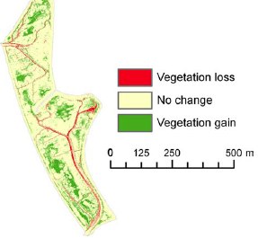
Tuxen, et al. 2008. Restoration Ecology. Vegetation colonization in a restored marshWe used NDVI to document vegetation colonization in a restoring salt marsh. This method was effective at detecting change in vegetation over time in a variable tidal marsh environment using imagery that had inconsistent specifications and quality across years.

Click to read more ...

Sunday
Jun292008

Fire occurrence probability in Spain

Lozano et al. 2008. Remote Sensing of Environment. This research explores the relationships between fire occurrence and several families of environmental factors at different spatial observation scales by means of classification and regression tree models. Predictors accounting for vegetation status (estimated by spectral indices derived from Landsat imagery), fire history, topography, accessibility and vegetation types were included in the models of fire occurrence probability.

Click to read more ...

Saturday
May312008

Mapping SOD related stress with CASI

Pu, R., M. Kelly, G. L. Anderson, and P. Gong. 2008. Using CASI hyperspectral imagery to detect mortality and vegetation stress associated with a new hardwood forest disease. Photogrammetric Engineering & Remote Sensing 74(1): 65‐75

A CASI dataset was used for detecting mortality and vegetation stress associated with a new forest disease. Pdf download.

Wednesday
Oct312007

Spatial‐temporal tree mortality patterns associated with SOD

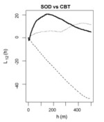
Liu, et al. 2007. Forest Ecology and Management. Inhomogeneous cross-K-functions of SOD and California bay trees: the peak in the dark line indicates co-clusteringWe analyzed the spatial–temporal patterns of overstory oak tree mortality in China Camp State Park, CA over 4 years using the point patterns mapped from high spatial resolution remotely sensed imagery. Both univariate and multivariate spatial point pattern analyses were performed (inhomogeneous K-functions and Neyman–Scott point processes) to characterize the spatial dependence among dead oak trees in each year, and between dead oaks and CA bay trees.

Click to read more ...

Sunday
Sep302007

Modeling SOD risk in the United States

Kelly, et al. 2007. Computers, Environment and Urban Systems. Risk for SOD in the southeast based on model agreementUsing the locations of P. ramorum in CA we derived a risk map for SOD spread in the conterminous US using 5 environmental niche models: Expert-driven Rule-based, Logistic Regression, Classification and Regression Trees, Genetic Algorithms, and Support Vector Machines.

Click to read more ...

Friday
Aug312007

Web‐based participatory research informatics

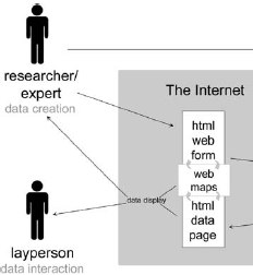
Pederson et al. 2007. Ecological Informatics. Scientific datasets are often generated and used by “communities”, or groups of users and creators. Here we describe a system for promoting collaboration in the creation, maintenance, and use of dynamic data over the web.

Click to read more ...

Monday
Apr302007

Obia for mapping dead trees

Guo, Q. C., M. Kelly, P. Gong and D. Liu. 2007. GIScience and Remote Sensing. An object, defined by spectral similarity of neighboring pixelsWe developed an object-based approach, including an image segmentation process and a knowledge-based classifier, to detect individual tree mortality in imagery of 1 m spatial resolution.

Click to read more ...

Monday
Apr302007

Spatial pattern of fires in the Sierra Nevada

Collins, B. M., M. Kelly, J. W. V. Wagendonk and S. L. Stephens. 2007. Landscape Ecology. Mapped fire severityWe use gridded estimates of fire severity, derived from Landsat ETM+ imagery, to identify the biotic and abiotic factors contributing to the observed spatial patterns of fire severity in two large natural fires. Regression tree analysis indicates the importance of weather, topography, and vegetation variables in explaining fire severity patterns between the two fires.

Click to read more ...

Page 1 ... 6 7 8 9 10 ... 11 Next 10 Entries »