publications by year

Selected Publications

My CV can be found here, my Google Scholar page is here and my Research Gate page is here. Links to directly downloadable papers are provided when possible - these are for individual use only; links to journals are also provided, but might not be available to users without campus library access. All papers are available upon request.

Entries in remote sensing (51)

Thursday
Dec132012

Low density lidar provides valuable plot-level forest data

Jakubowski, M., Q. Guo, and M. Kelly. 2013. Tradeoffs between lidar pulse density and forest measurement accuracy. Remote Sensing of Environment. 130: 245–253.

lidar density examples: 9 - 0.01 pl/m2

Discrete lidar is increasingly used to analyze forest structure. Technological improvements in lidar sensors have led to the acquisition of increasingly high pulse densities, possibly reflecting the assumption that higher densities will yield better results. In this study, we systematically investigated the relationship between pulse density and the ability to predict several commonly used forest measures and metrics at the plot scale. The accuracy of predicted metrics was largely invariant to changes in pulse density at moderate to high densities. In particular, correlations between metrics such as tree height, diameter at breast height, shrub height and total basal area were relatively unaffected until pulse densities dropped below 1 pulse/m2. Metrics pertaining to coverage, such as canopy cover, tree density and shrub cover were more sensitive to changes in pulse density, although in some cases high prediction accuracy was still possible at lower densities.

Click to read more ...

Friday
Jan202012

Finding trees in the lidar point cloud

individual trees extracted from the lidar point cloudLi, W., Q. Guo, M. Jakubowski and M. Kelly. 2012. A new method for segmenting individual trees from the lidar point cloud. Photogrammetric Engineering and Remote Sensing 78(1): 75-84

In this study we develop a new algorithm to segment individual trees from the small footprint discrete return airborne lidar point cloud. The new algorithm adopts a top-to-bottom region growing approach that segments trees individually and sequentially from the tallest to the shortest. We experimentally applied the new algorithm to segment trees in a mixed coniferous forest in the Sierra Nevada Mountains in California, USA. Our results indicate that the proposed algorithm has good potential in segmenting individual trees in mixed conifer stands of similar structure using small footprint, discrete return lidar data.

Click to read more ...

Wednesday
Nov162011

Mapping downed logs with lidar + obia

downed logs in redBlanchard, S., M. Jakubowski, and M. Kelly. 2011. Object-based image analysis of downed logs in a disturbed forest landscape using lidar. Remote Sensing 3(11): 2420-2439.

Downed logs on the forest floor provide habitat for species, fuel for forest fires, and function as a key component of forest nutrient cycling and carbon storage. This study evaluates the utility of discrete, multiple return airborne lidar-derived data for image object segmentation and classification of downed logs in a disturbed forested landscape and the efficiency of rule-based object-based image analysis (OBIA) and classification algorithms.

Click to read more ...

Thursday
Oct202011

Use of obia in public health - a review, and call for more

Kelly M., S. Blanchard. E. Kersten and K. Koy. 2011. Object-based analysis of imagery in support of public health: new avenues of research. Remote Sensing 3:2321-2345

The benefits of terrestrial remote sensing in the environmental sciences are clear across a range of applications, and increasingly remote sensing analyses are being integrated into public health research. This integration has largely been in two areas: first, through the inclusion of continuous remote sensing products such as normalized difference vegetation index (NDVI) or moisture indices to answer large-area questions associated with the epidemiology of vector-borne diseases or other health exposures; and second, through image classification to map discrete landscape patches that provide habitat to disease-vectors or that promote poor health. In this second arena, new improvements in object-based image analysis (or “OBIA”) can provide advantages for public health research. This paper provides a brief review of what has been done in the public health literature with continuous and discrete mapping, and then highlights the key concepts in OBIA that could be more of use to public health researchers interested in integrating remote sensing into their work.

Click to read more ...

Friday
May132011

Challenges of measuring methane over peatlands

Baldocchi, D., M. Detto, O. Sonnentag, J. Verfaillie, Y. A. Teh, W. Silver, and M. Kelly. 2012. The challenges of measuring methane fluxes and concentrations over a peatland pasture. Agricultural and Forest Meteorology 153(1): 177-187

We report on methane (CH4) concentrations and efflux densities that were measured over a drained and grazed, peatland pasture in the Sacramento-San Joaquin River Delta of California over a three year period. The site was ideal for micrometeorological flux measurements due to its very flat topography, its exposure to vigorous winds and its extended fetch along the predominant wind direction. Nevertheless, the interpretation of methane fluxes with eddy covariance proved to be extremely complicated by a number of geographical, biophysical, biogeochemical and site management factors.

Keywords: Eddy covariance . Peatland . Wetland . Cattle . Rice . Methane . Laser spectrometer . Biogeochemistry

Friday
Apr082011

Tracking the structural and functional development of a perennial pepperweed 

Sonnentag O, Vargas R, Detto M, Runkle BRK, Kelly M, and Baldocchi DD. 2011. Tracking the structural and functional development of a perennial pepperweed (Lepidium latifolium L.) infestation using a multi-year archive of webcam imagery and eddy covariance measurements. Agricultural Forest Meteorology: 151:916-926

We explore the ability of red (R)–green (G)–blue (B) color space information to track the structural and functional development of a perennial pepperweed (Lepidium latifolium L.) infestation in California.

Click to read more ...

Monday
Dec272010

Mapping changes in tidal wetland vegetation composition

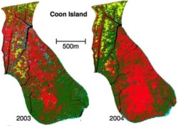
Tuxen, K, L Schile, D Stralberg, S Siegel, T Parker, M Vasey, J Callaway, and M Kelly. 2011. Mapping changes in tidal wetland vegetation composition and pattern across a salinity gradient using high spatial resolution imagery. Wetland Ecology and Management 19:141-157

Coon Island vegetation over two years. We mapped vegetation at six tidal marshes (two natural, four restored) in the San Francisco Estuary, CA, USA, between 2003 and 2004 using detailed vegetation field surveys and high spatial-resolution color-infrared aerial photography. Vegetation classes were determined by performing hierarchical agglomerative clustering on the field data collected from each tidal marsh.

Click to read more ...

Friday
Dec172010

Carbon dioxide exchange of a pepperweed infestation

Sonnentag, O., M. Detto, B. Runkle, Y. Teh, W. Silver, M. Kelly, and D. D. Baldocchi. 2011. Carbon dioxide exchange of a pepperweed (Lepidium latifolium L.) infestation: how do flowering and mowing affect canopy photosynthesis and autotrophic respiration? J. Geophys. Res., 116, G01021, doi:10.1029/2010JG001522

We analyzed CO2 flux measurements made with eddy covariance over a pepperweed infestation in California, covering three growing seasons. We found that unmowed pepperweed caused the site to be almost CO2 neutral or a net source, and mowing during early flowering caused the site to act as a net CO2 sink.

Click to read more ...

Friday
Nov122010

Pattern metrics for wetland restoration management

Kelly, M., K. Tuxen and D. Stralberg. 2011. Mapping changes to vegetation pattern in a restoring wetland: Finding pattern metrics that are consistent across spatial scale and time. Ecological Indicators 11: 263-273. We sought to identify pattern metrics that are consistent across spatial scale and time – and thus robust measures of vegetation and habitat configuration – for a restored tidal marsh in the San Francisco Bay, CA, USA.

Click to read more ...

Wednesday
May122010

Predicting bird abundance in tidal marshes

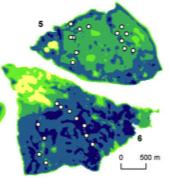
Predicted mean abundance for common yellowthroat at Browns Is. and Sherman Lake

Stralberg, D., M. Herzog, N. Nur, K. Tuxen, S. Siegel and M. Kelly. 2010. Predicting avian abundance within and across tidal marshes using fine-scale vegetation and geomorphic metrics. Wetlands 30: 475-487

We used a blend of fine-scale remote sensing products and field-based survey data via spatial predictive models to aid in monitoring restoring tidal marshes for bird habitat. We developed a suite of 1-m pixel-level spatial metrics describing patterns in marsh vegetation and geomorphology for six sites across a large salinity gradient, and used these to predict avian abundance.

Click to read more ...