publications by year

Selected Publications

My CV can be found here, my Google Scholar page is here and my Research Gate page is here. Links to directly downloadable papers are provided when possible - these are for individual use only; links to journals are also provided, but might not be available to users without campus library access. All papers are available upon request.

Entries in remote sensing (51)

Monday
Nov302009

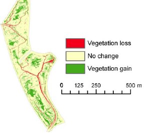
Large-scale deforestation in Jinotega, Nicaragua: 1978-1999 

Zeledon, E. and M. Kelly. 2009. Understanding large-scale deforestation in southern Jinotega, Nicaragua from 1978 to 1999 through the examination of changes in land use and land cover. Journal of Environmental Management 90: 2866-2872

Keywords: Agricultural frontier . Applied remote sensing . Central America . Forest cover . Postclassification

Friday
Oct312008

OBIA for classifying urban environments for fire management

Cleve, C., M. Kelly F. Kearns and M. Moritz. 2008. Classification of urban environments for fire management support: A comparison of pixel- and object-based classifications using high-resolution aerial photography. Computers, Environment and Urban Systems 32: 317–326

We explore the accuracy of pixel-based and object-based classification methods used for mapping in the wildland–urban interface (WUI) with free, readily available, high spatial resolution urban imagery, which is available in many places to municipal and local fire management agencies. Results indicate that an object-based classification approach provides a higher accuracy than a pixel-based classification approach when distinguishing between the selected land-use and land-cover categories. Pdf download. Journal link.

Keywords: Wildland–urban interface . Classification . Image analysis . Object-based methods . Remote sensing

Sunday
Aug312008

Including the spatial relations of objects in classification

Liu, et al. 2008. ISPRS Journal of Photogrammetry and Remote Sensing. We establish a context where objects are areal (not points or lines) and non-overlapping (we call this “single-valued” space), and propose a framework of binary spatial relations between segmented objects to aid in object classification.

Click to read more ...

Wednesday
Jul302008

Oak health and leaf spectral response

Pu et al. 2008. GeoCarto International. The spectroscopic determination of two health levels of the coast live oak leaves was conducted with three sets of spectra. Based on our experimental results and previous work, existing remote sensing techniques, including airborne or satellite remote sensing and multispectral or hyperspectral remote sensing, may be insufficient for monitoring and mapping disease-induced moisture stress in trees that have recently been infected.

Click to read more ...

Wednesday
Jul302008

Mapping vegetation colonization in a restoring tidal marsh

Tuxen, et al. 2008. Restoration Ecology. Vegetation colonization in a restored marshWe used NDVI to document vegetation colonization in a restoring salt marsh. This method was effective at detecting change in vegetation over time in a variable tidal marsh environment using imagery that had inconsistent specifications and quality across years.

Click to read more ...

Sunday
Jun292008

Fire occurrence probability in Spain

Lozano et al. 2008. Remote Sensing of Environment. This research explores the relationships between fire occurrence and several families of environmental factors at different spatial observation scales by means of classification and regression tree models. Predictors accounting for vegetation status (estimated by spectral indices derived from Landsat imagery), fire history, topography, accessibility and vegetation types were included in the models of fire occurrence probability.

Click to read more ...

Saturday
May312008

Mapping SOD related stress with CASI

Pu, R., M. Kelly, G. L. Anderson, and P. Gong. 2008. Using CASI hyperspectral imagery to detect mortality and vegetation stress associated with a new hardwood forest disease. Photogrammetric Engineering & Remote Sensing 74(1): 65‐75

A CASI dataset was used for detecting mortality and vegetation stress associated with a new forest disease. Pdf download.

Wednesday
Oct312007

Spatial‐temporal tree mortality patterns associated with SOD

Liu, et al. 2007. Forest Ecology and Management. Inhomogeneous cross-K-functions of SOD and California bay trees: the peak in the dark line indicates co-clusteringWe analyzed the spatial–temporal patterns of overstory oak tree mortality in China Camp State Park, CA over 4 years using the point patterns mapped from high spatial resolution remotely sensed imagery. Both univariate and multivariate spatial point pattern analyses were performed (inhomogeneous K-functions and Neyman–Scott point processes) to characterize the spatial dependence among dead oak trees in each year, and between dead oaks and CA bay trees.

Click to read more ...

Monday
Apr302007

Obia for mapping dead trees

Guo, Q. C., M. Kelly, P. Gong and D. Liu. 2007. GIScience and Remote Sensing. An object, defined by spectral similarity of neighboring pixelsWe developed an object-based approach, including an image segmentation process and a knowledge-based classifier, to detect individual tree mortality in imagery of 1 m spatial resolution.

Click to read more ...

Sunday
Apr292007

Watershed land use and wetland disturbance

Byrd, et al. 2007. Environmental Management. We show that salt marsh recovery after disturbance depends on relative cover of different land use classes in the watershed, with greater chances of recovery associated with less intensive agriculture.

Click to read more ...